
Department of Transportation
Division of Planning and Policy
PROPOSED
PUBLIC NOTICE
2309 Standards and Regulations for Subdivision Streets and State Highway Access
Statutory Authority
Background
The Delaware Department of Transportation through its Planning Division has developed proposed revisions to its regulations for access to State-maintained roads and for planning, design, construction, and acceptance for maintenance of subdivision streets. This proposed revision to the Standards and Regulations for Subdivision Streets and State Highway Access is the first revision to the regulations that were enacted in December of 2007.
These regulations define the requirements which apply to:
Attached to this announcement is a summary of the proposed changes to the regulations. In addition, proposed deletions are shown as stricken through text and proposed new language is shown as underlined text.
A public workshop will be held regarding these proposals on November 19, 2009 at the DelDOT Administration Building in the Farmington/Felton Room from 4:00 pm until 7:00 pm.
The Department will take written comments on the proposed changes to the Regulations from November 1, 2009 through December 17, 2009.
Any requests for copies of the Regulations, or any questions or comments regarding amendments to these Regulations should be directed to:
Theodore Bishop, Assistant Director of Planning
Delaware Department of Transportation
PO Box 778
Dover, DE 19903
(302) 760-2122 (telephone)
(302) 739-2251 (fax)
theodore.bishop@state.de.us
2309 Standards and Regulations for Subdivision Streets and State Highway Access
The purpose of DelDOT’s Standards and Regulations for Subdivision Streets and State Highway Access is to set forth the requirements of the State of Delaware, Department of Transportation for access to State-maintained roadways and for the planning, design, construction, and acceptance for maintenance of subdivision streets.
Land development and subdivisions have a direct impact on the transportation system. These impacts have to be assessed to ensure that the system is safe and efficient.
The efficiency and safety of a roadway depends to a large extent upon the amount and character of interruption in the movement of traffic. Vehicles entering, leaving, or crossing the roadway, or standing nearby, cause most interruptions in traffic.
Property owners fronting State-maintained roadways have certain rights of access consistent with the zoning and use of their property (except along controlled or limited access highways). In addition, the traveling public who use those State-maintained roadways have certain rights to freedom of movement and safety.
The standards and regulations presented herein are intended to regulate and control the location, design, and operation of access points and transportation facilities maintained by DelDOT. All commercial entrances, residential entrances and subdivision streets are to be designed and constructed in accordance with these requirements. These requirements apply to the following:
1.1 Legal Authority
The authority for DelDOT’s Standards and Regulations for Subdivision Streets and State Highway Access is set forth in the Delaware Code. Applicable sections include:
Pursuant to Title 17 of the Delaware Code, the State of Delaware Department of Transportation (DelDOT) is charged with the responsibility of controlling all access points to State-maintained roadways. Relevant portions of this section are as follows:
Title 17 – Highways, Chapter 1, Section 131 – General Jurisdiction
(b) All roads and streets situate in unincorporated suburban communities throughout the State which were built or created between July 1, 1935, and July 1, 1951, whether paved or unpaved, shall henceforth be under the absolute care, management and control of the Department and shall be maintained, repaired and reconstructed by the said Department.
(e) All roads and streets not dedicated to the public use and intended to be private, as indicated on the filing plan, situated in an unincorporated suburban community within the State, shall be constructed in accordance with rules and regulations adopted by the county in which such road or street is located. Such rules and regulations for construction of private subdivision streets and roads shall, in addition to specifying standards for the design and construction of such private streets and roads, establish a mechanism to provide for the perpetual maintenance of such private streets and roads, but in no event shall the State or county be responsible for such maintenance. In addition, the following provisions shall apply to all such streets and roads:
(1) In the event that the county has not adopted rules and regulations for construction of private subdivisions, streets and roads or such rules and regulations have been established and there is no mechanism contained therein to provide for the perpetual maintenance of private subdivision streets or roads, all such roads or streets shall be constructed in accordance with standards set forth by the Department of Transportation, Division of Highways, for streets and roads dedicated to public use.
(2) Private roads or streets shall not be accepted for maintenance by the State until the right-of-way for the streets or roads has been dedicated to the public use, accepted by the State and the streets and roads constructed or reconstructed at the expense of the property owners in accordance with the standards established by the Department of Transportation, Division of Highways, for streets and roads dedicated to public use in accordance with Chapter 5 of Title 9.
(3) In the event any real property with road frontage or a private road or street, constructed or reconstructed pursuant to this section, which road or street is not to be maintained by the State, is conveyed subsequent to such construction or reconstruction, the deed conveying such real property shall contain a statement that such private street or road is not maintained by the State.
(4) Any private road, street or thoroughfare in the State shall be constructed either in accordance with state standards and pursuant to department rules and regulations or pursuant to rules and regulations established by the county. In either event, a mechanism for perpetual maintenance must be established. The State and county shall have concurrent jurisdiction to enforce the requirements of this section by legal or equitable means. The county shall withhold the issuance of building or occupancy permits for any structure abutting such road, street or thoroughfare to insure compliance with the requirements of this section.
(f) The Department of Transportation, Division of Highways, is hereby authorized to inspect all suburban community street construction and to establish and collect fees for the inspection of said street construction in amounts deemed necessary to defray costs of administering this section. All fees collected shall be placed to the credit of the Department of Transportation, Division of Highways.
(g) All roads and streets situated in unincorporated suburban communities throughout the State which were built between July 1, 1951, and July 1, 1975, whether paved or unpaved, shall, upon dedication of a right-of-way to public use, henceforth be under the absolute care, management and control of the Department of Transportation, Division of Highways, and shall be maintained, repaired and reconstructed by the said Department of Transportation, Division of Highways. Said right-of-way shall be determined by the Department of Transportation, Division of Highways, in accordance with physical conditions, but in no case shall be less than 30 feet in width. Dedication of the right-of-way must occur prior to June 30, 1978, to qualify for the aforementioned responsibilities under the auspices of this section.
(i) In connection with the Department's review of subdivision proposals affecting the transportation system, it is authorized to collect fees for the costs of administering the subdivision approval process.
Title 17 – Highways, Chapter 1, Section 141 – Regulation of Traffic; Exceptions
(a) The Department shall have jurisdiction and control of all state highways of this State outside of the limits of incorporated cities and towns for the purpose of regulating traffic and for the use and operation of all vehicles thereover, and may adopt any and all rules and regulations respecting the use of such highways and the operation of all vehicles upon the same.
(b) Each rule and regulation adopted pursuant to this section shall be in the form of a resolution signed by the Secretary or the Secretary's designee. A permanent record of these shall be kept by the Department and at the time of adoption a copy of each shall be forwarded to the Department of Safety and Homeland Security and to the New Castle County police, if within their jurisdiction.
(c) Pursuant to this section, the Department is authorized to perform all engineering studies and traffic investigations necessary to implement this section and Chapter 41 of Title 21, and to install, maintain, operate and remove all traffic control devices necessary to implement Chapter 41 of Title 21 and regulations adopted thereunder.
(d) The Department, on the basis of engineering studies and traffic investigations, may prohibit the operation of trucks or other commercial vehicles or impose limitations as to the weight thereof on designated highways which prohibitions and limitations shall be posted as set forth in § 4505 of Title 21.
(e) Nothing in this section shall be construed as granting the Department the power to make any rules and regulations respecting the use of highways contrary to Delaware law.
Title 17 – Highways, Chapter 1, Section 146 – Access to state-maintained highways
(a) The Department is authorized to adopt standards and regulations for the location, design, construction, reconstruction, maintenance, use and control of vehicular and pedestrian access to and from any state-maintained highway in order to protect public safety, to maintain smooth traffic flow, to maintain highway right-of-way drainage, to regulate drainage from property leading into or carried by the highway drainage system and any other public purpose, as determined by the Department.
(b) No person, firm, corporation or the like shall construct, open, reconstruct, maintain, modify or use any crossing or entrance onto a state-maintained highway, street or road, including any drainage modifications leading into or carried by the highway drainage system, without first having complied with standards and regulations adopted by the Department and having obtained a permit issued by the Department.
(c) Any person, firm, corporation or the like who constructs, opens, reconstructs, maintains, uses or modifies an entrance onto or an exit from a state-maintained highway, street or road without first having complied with standards and regulations adopted by the Department and having obtained a permit from the Department for such entrance or exit shall be punished by a fine of not less than $100 nor more than $1,000 for each offense, and a further sum in an amount equal to the amount fined for the initial offense for each and every day such violation exists.
(d) For purposes of this section, whenever the use to which a property is being put is changed such that there will be a significant alteration in the character, flow or volume of traffic, as determined within the sole discretion of the Department, a new permit shall be required.
(e) The Justice of the Peace Courts shall have jurisdiction over violations of this section.
(f) In addition to whatever legal or equitable remedies are available, the Department may install barricades across or remove any entrance or exit constructed, opened, reconstructed, maintained, modified or used in violation of this section and the standards or regulations adopted pursuant thereto, at the expense of the property owner.
Title 17 – Highways, Chapter 5, Section 508 – Dedication of new roads for state maintenance; approval required; security.
(a)
(1) No person, firm or corporation shall construct, or cause to be constructed any new road or street outside the corporate limits of any city or town and intended to be dedicated by the owner thereof to the public use, including the initial installation of traffic and street name signs, unless such road or street is in conformity with plans and specifications approved by the Department and with this section. At a minimum, the initial installation of street name signs must include the placement of such signs at each intersection of the new street with any other street, capable of being read from each direction on any street at each intersection. The new road or street shall be a continuation of an existing or proposed public road designed to be part of the general highway system of the State. Such construction shall be performed pursuant to a written agreement, signed by the developer as hereinafter defined incorporating but not limited to the plans and specifications approved by the Department, the posted security for completion, the location of any decorative subdivision entrance signs installed by the developer, and whatever other terms the Department, in its sole discretion, determines may be necessary. The owner or person actually engaged in any development or construction of residential or commercial property as determined by the Department which will affect or require access onto state-maintained highways, streets and roads shall be known as the "developer" for purposes of this section.
(2) Pursuant to the terms of this section and such rules, regulations, standards and/or regulations as may be adopted by virtue thereof, the Department shall accept such roads or streets constructed in compliance herewith into the state maintenance system; provided, however, that with regard to any road or street constructed to serve any dwelling, building or facility, etc., other than single family residences, the Department shall have the sole discretion as to whether such road or street shall be accepted into the state maintenance system.
(b) Before commencement of any construction undertaken pursuant to this section, including the installation of utilities within the dedicated right-of-way, the developer shall first post with the Department a good and sufficient bond, certified check, Letter of Credit or other form of security in a manner and form approved by the Department and in such amount as may be fixed, but not to exceed 10% of the estimated cost of such construction as approved by the Department, which bond, certified check, Letter of Credit or the like, shall be conditioned on the faithful performance and satisfactory completion of the obligations imposed by subsection (a) of this section. In the event the developer, regardless of corporate name, has been adjudged by the Department to be in violation of this section and/or has not maintained a satisfactory record of compliance on repair and construction completion as determined by the Department, then the Department may require a bond, certified check, Letter of Credit or other form of security, consistent herewith in an amount not to exceed 100 percent of the cost of such construction.
(c)
(1) The Department shall inspect any new road or street being constructed in accordance with this section as well as any construction including utilities within the road or street right-of-way to insure that the construction is in conformity with standards, plans and specifications approved by the Department. Upon dedication of the right-of-way to the public use and satisfactory completion of the street or road construction including its connection to an existing state maintained road within the sole judgment, discretion and approval thereof by the Department, the Department shall so notify the developer that the new road or street has been accepted into the state maintenance system and that the dedicated right-of-way has been accepted according to the terms of such acceptance.
(2) A signature from a Department inspector shall be obtained before the Department can accept a road from a developer into the state maintenance system.
(3) The Department shall inform by letter an officer of the maintenance association, if any, in the development in which the road will be dedicated, that the Department has accepted the road from the developer. The Department shall send copies of such letter to the state Senator and state Representative. Such letter shall indicate the acceptance date of the roadway(s) and an explanation of the State's 3-year good faith warranty.
(4) The Department, upon acceptance, shall thereafter assume the sole and absolute care, management and control of the new road or street as a public road or street. Until such time as the Department accepts the new road or street, the developer or the developer's legal successor in interest shall be solely responsible for maintenance thereof.
(5) The Department's standards for newly constructed residential subdivision streets include a decorative sign that includes the name of the subdivision and a logo of the State's famous patriot, Caesar Rodney. These new signs shall be installed at each newly approved subdivision and shall be paid for by the developer or developers of such subdivision. Existing subdivisions may also request the Department to install these new signs in place of other signs previously used by the Department. Such requested replacement signs shall be paid for by the subdivision or from Community Transportation Funds allocated by a legislator requesting such signs. The Department shall replace existing standard signs damaged by vandalism, accident, or the ravages of time with standard signs under its regular maintenance program, unless the decorative alternative has been requested under the provisions of this subsection.
(d) In order to carry out the purpose of this section, the Department shall make and publish rules, regulations, standards and/or specifications for planning, designing, constructing and maintaining any new road or street.
(e) The bond, certified check, Letter of Credit or other acceptable forms of security, posted with the Department shall be immediately due and owing upon failure of the developer to meet the obligations set forth in the agreement executed pursuant to this section. Upon failure of the developer to comply with the standards, plans and specifications and/or with the terms of the said construction agreement, the Department may:
(1) Withdraw any approval to construct such road or street which it has given pursuant to this section and may thereafter notify the appropriate governmental agency to cease issuance of occupancy permits for dwellings in the construction area;
(2) Proceed to forfeiture of the bond, certified check, Letter of Credit or other form of security;
(3) Move to fine violators pursuant to this section;
(4) Seek specific performance of the developer's agreement;
(5) Within its sole discretion, conditionally accept and satisfactorily complete the road or street and recover damages in the amount of completion costs and incidental expenses from the developer; and/or
(6) Institute whatever other legal or equitable actions necessary to cause the streets to be completed.
1.2 Access application and Approval Process
This section outlines the procedures to be followed by developers and/or property owners in order to obtain approval of a commercial access or a State-maintained subdivision street. Access applications, construction permits and procedures for residential units are outlined in Chapter 7. The estimated review time by DelDOT is based on a complete submission. Incomplete submissions will be returned to the developer for resubmission. This process is illustrated in Figure 1-2.
DelDOT reviews the site plan in accordance with these Standards and Regulations for Subdivision Streets and State Highway Access. When the plan meets the requirements of DelDOT, a “No Objection to Recordation” letter shall be issued to the governing land use agency. The initial stage fee as outlined herein shall be paid prior to issuance of the “No Objection” letter.
DelDOT will also review construction plans for subdivision streets and/or entrances in accordance with Standards and Regulations for Subdivision Streets and State Highway Access. Construction plans must be signed and sealed by a land surveyor or professional engineer registered in Delaware as outlined in Chapter 4.
The construction stage fee must be paid prior to review of the semi-final construction plan. If the requirements outlined in these Standards and Regulations for Subdivision Streets and State Highway Access are not met by the second semi-final plan submission, then a new application and construction stage fee shall be required prior to further reviews. Upon review and final approval of the final construction plan, DelDOT will issue an approval letter.
Any site being considered by DelDOT for access on to a State-maintained roadway shall be evaluated to determine if it will also impact any other DelDOT programs. These programs include, but are not limited to, the Corridor Capacity Preservation Program (CCPP), the Capital Transportation Program (CTP), the Transportation Enhancement (TE) Program, the Highway Safety Improvement Program (HSIP), and the Pavement Rehabilitation Program. If a plan would have an affect on any of these programs, DelDOT may require additional reviews and additional requirements to be met.
1.3 Application
The application with supporting documents and the appropriate number of plans as outlined in Chapter 6 shall be submitted to the Public Works Subdivision Engineer of the District in which the construction shall take place for review and approval. The locations and addresses of the District offices are as follows: mailing address is Department of Transportation, P.O. Box 778, 800 Bay Road, Dover, DE 19903.
Figure 1-1 DelDOT Districts
|
New Castle County (DelDOT Canal District) 250 Bear-Christiana Road Bear, DE 19701 Kent County (DelDOT Central District) 930 Public Safety Boulevard Dover, DE 19901 Sussex County (DelDOT South District) P.O. Box 490 Georgetown, DE 19947 |
1.3.1 Approval of Application. The approval of the application shall be subject to the following conditions:
1.3.1.1 The application shall be properly and clearly completed as determined by DelDOT. Applications found to be unsatisfactory shall be returned for correction and resubmission.
1.3.1.2 The location, design, and construction of driveways and entrances shall meet the geometric requirements of DelDOT. Necessary provisions for drainage, pavement types and thicknesses, sight distance and other construction details shall conform to the current requirements of DelDOT.
1.3.1.3 When access provisions cannot be provided in accordance with DelDOT's requirements due to limitations particular to the site or where the applicant refuses to comply, the access application for the intended use may be denied.
1.3.2 Review of the Plan. The following documents shall be submitted to the Public Works Subdivision Engineer of the appropriate District to start the review process for a commercial entrance or proposed subdivision:
DelDOT’s site plan and site street plan requirements are outlined in Chapter 3. DelDOT must review and approve the site plan and issue the “No Objection” letter prior to granting entrance approval. Submission of a site plan and issuance of a “No Objection” letter is required independent of the local land use agency’s requirements.
The requirements for the entrance plan are outlined in Chapter 4. DelDOT will review and comment on the preliminary entrance plan prior to issuance of a “No Objection” letter to the local land use agency.
Once DelDOT has issued its “No Objection” letter for the site plan, the semi-final entrance plan can be submitted along with the construction stage fee. DelDOT will then distribute the semi-final plan to the support sections (e.g., Traffic Section, Pavement Management Section) for review and comment.
Upon addressing all comments provided by DelDOT in a comment / response letter, the final construction plan can be submitted. When DelDOT notifies the applicant that the final construction plan meets the requirements outlined in these Standards and Regulations for Subdivision Streets and State Highway Access, the applicant shall submit the appropriate number of signed and sealed sets of plans for final approval by DelDOT (see Chapter 4).
1.3.3 Approval of the Plan. Following DelDOT's approval of the construction plan, the applicant’s engineer shall receive one two copyies of the approved plan from the Subdivision Engineer. The approved construction plan shall be valid for three six months.
1.3.4 Construction. The applicant shall submit construction documents (application, security, plans) for the work as outlined in Chapter 6. After review and approval of the security and the required construction documents, the Public Works Engineer shall issue the Notice to Proceed (NTP). No work shall be undertaken until DelDOT issues a NTP. For commercial sites, a Commercial Entrance Construction Permit (see Appendix E) will be issued in addition to NTP.
Upon completion of the construction to the satisfaction of DelDOT, in accordance with the terms of the Permit, DelDOT shall release the security and issue an entrance permit or begin the acceptance procedure when appropriate.
1.4 Review Fees
1.4.1 Review fees (as applicable) will be assessed for all development proposals as follows stages:
1.4.2 The following applies to determining and collecting fees to cover the costs of administering the review of a typical land development proposal. All fees are non-refundable.
1.4.2.1 Traffic Impact Study Review: A Fee of $5000 is collected when an applicant requests confirmation of the Scope of Work for the study.
1.4.2.2 Initial Stage: Fees are collected at the time of submission of the approved record plan for DelDOT’s review. The fees associated with this stage reimburse DelDOT for all plan review activities before final plan approval by the local land use agency. An “Initial Stage Fee Calculation Form” must be submitted with the fee (See Appendix C), which is calculated as follows:
1.4.2.3 Construction Stage: Fees are collected at the time of submission of the construction plans for the Department’s review. The fees associated with this review reimburse the Department for the technical review of subdivision street plans and highway access plans. A “Construction Stage Fee Calculation Form” must be submitted with the fee (see Appendix C), which is calculated as follows:
1.4.2.4 Non-Conforming Submissions: Some plan submissions will not fit into the previously described categories. Developments such as subdivisions with private streets; mobile home parks; golf courses; and borrow pits fall into this category. Plans for such non-conforming developments shall be considered as one lot non-residential. Therefore, the Initial Stage Fee for these developments will be $520.
1.4.2.5 National Pollution Discharge Elimination System (NPDES) fees: The applicant is required to pay National Pollution Discharge Elimination System (NPDES) fees when DelDOT reviews a stormwater management facility as part of an offsite improvement project where DelDOT has the review and approval authority for the facility. The fee is $195 per plan.
1.4.3 All fees shall be submitted to the Subdivision Engineer or designee with the appropriate fee calculation form and plan submission. The Subdivision Engineer shall review for accuracy the fee calculation form with respect to the plan and fee submitted. Once reviewed and approved for accuracy, the reviewer will give the check/money order to the Division’s financial management unit. The financial management unit will record the payment, assign an internal control number, and initiate the process to deposit the fee with the DelDOT Office of Finance.
1.4.4 Fee Administration. The Department will not accept a record plan or construction plan submission without a respective fee calculation form and payment. Should any payment received be deemed insufficient, one of the following two options are available at the discretion of the Department:
Only checks or money orders will be accepted and shall be made payable to the Delaware Department of Transportation.
The Department’s Cash Receipt Policy must be followed in order to be in compliance with Title 29 of the Delaware Code, Section 6103 (all receipts in excess of $100 per day must be deposited daily). The date that applications/fees are received in the Division’s financial management unit in the Department’s administration building in Dover will be used and recorded for this purpose.
Separate spreadsheets have been developed to track and record fees received by the Division’s financial management unit for Initial Stage Fees and Construction Stage Fees. These spreadsheets are utilized to record the payment, verify fees received and perform monthly reconciliation of revenues.
1.5 Definitions
“AASHTO Standards” Policies and Standards published by American Association of State Highway and Transportation Officials.
“Acceleration Lane” A speed-change lane, including tapered areas, for the purpose of enabling a vehicle entering a roadway to increase its speed to a rate at which it can more safely merge with through traffic.
“Access” Any driveway or other point of access such as a street, road, or highway that connects to the general street system. Where two public roadways intersect, the secondary roadway shall be considered the access.
“Access Category” One of five categories described in Chapter 9 of the Standards and Regulations for Subdivision Streets and State Highway Access that determines the degree to which access to a state highway is controlled.
“Accessway” A connection other than a sidewalk or walkway that provides bicycle and pedestrian passage between streets, between a street and a destination, or connecting to an existing or proposed trail.
“Alley” A privately maintained street dedicated for public use which provides secondary access along the rear lot line of adjoining properties. Alleys are intended to accommodate access to parcels and service delivery such as trash collection and utility service.
“Applicant” An individual or firm seeking either approval from DelDOT for an access application or from a local government for rezoning, conditional use or subdivision application.
“Applicant’s Engineer” An engineer licensed in Delaware and retained by the applicant to perform engineering services associated with their expertise.
“Approved Study Area” The study area approved for analysis by DelDOT in the Traffic Impact Study or Traffic Operational Analysis Scope of Work Letter.
“Area-Wide Study” A study performed, generally in lieu of an individual TIS, for a designated area to determine the area-wide impacts of proposed developments within the specified study area that encompasses more than one possible development project.
“Average Daily Traffic (ADT)” The total volume of traffic during a given time period in whole days greater than one day and less than one year, divided by the number of days in that time period.
“Boulevard Street” A street which typically functions as a collector street which involves a landscaped median of varying width which divides opposing travel lanes by green space.
“Bypass Lane” A paved area to permit through traffic to bypass left-turning vehicles stopped on the travel lane.
“Commercial Access Street” A street typically within a planned business park that serves as a frontage street to abutting properties and which conducts traffic between commercial access streets and major collector and arterial roadways.
“Commercial Entrance” An entrance to serve a non-residential site.
“Committed Developments” Developments that are recorded or largely approved by the local jurisdiction but which have not yet been constructed.
“Community Constraints” Limitations on development created by community facilities, cultural or historic features, preserved open space or farmland preservation areas.
“Community Facilities” Public destinations of significance to a community including but not limited to schools, libraries, parks, senior and recreational centers, as well as other neighborhood facilities such as pools and tot lots.
“Connectivity” A measure of how efficiently a transportation network provides access between destinations. It is measured using a Connectivity Ratio.
“Connectivity Ratio” The ratio of links (street segments) to nodes (intersections and cul-de-sac heads). It is determined by dividing the number of street segments (street sections between intersections and/or cul-de-sac ends) by the number of intersections and cul-de-sac ends. For purposes of this calculation, proposed street intersections with existing roads and stub roads for future access to vacant developable lands shall count as 0.5 intersections.
“Connector Street” A continuous street or streets entirely in the suburban development subdivision street category beginning and ending on the state numbered road system, and having a high volume of through traffic.
“Construction Entrance” A temporary access for the ingress and egress of construction vehicles.
“Crossover” An opening in a median on a divided highway provided for crossing and turning traffic.
“Cul-de-Sac Street” A subdivision street with a single point of access which terminates at a circular paved turn-around. Also referred to as a “dead-end street”.
“Deceleration Lane” A speed change lane for vehicles leaving Category 1 functional classification roadways.
“Delaware MUTCD” Manual on Uniform Traffic Control Devices.
“Design Hour Volume (DHV)” A traffic vehicle volume determined for use in the geometric design of highways. It is the 30th highest hour vehicular volume experienced in a one-year period.
“Divided Highway” A highway with separated roadways for traffic in opposite directions, such separation being indicated by depressed dividing strips, raised curbing, traffic islands, or other physical separations.
“Division of Planning, Development Coordination Section (DelDOT)” The unit charged with the responsibility for reviewing subdivision and site plans, traffic impact studies, and development proposals within DelDOT, or such other unit or unit(s) that may be charged with the responsibility at some future date.
“Driveway” An access that is not a public street, road, or highway.
“Entering Lane” Traffic lane used exclusively for vehicles entering a roadside establishment.
“Exiting Lane” Traffic lane used exclusively for vehicles leaving a roadside establishment.
“Frontage” The length along the highway right-of-way of a single property tract or roadside development.
“Frontage Road” Means a public street or road auxiliary to and normally alongside of and parallel to a highway, constructed for the purposes of maintaining local road continuity and controlling direct access to the main highway.
“Full Movement Roadway” A roadway whose turning movements are not restricted when intersecting with a roadway of higher classification or designation.
“Functional Classification” A classification system that defines the purposes and hierarchy of all streets and highways within a network (classification system maps can be found on DelDOT’s website).
“FWOP (Future Without Project)” In a TIS, denotes the anticipated future traffic condition at a location without the addition of traffic generated by the proposed project.
“FWP (Future With Project)” In a TIS, denotes the anticipated future traffic condition at a location after the addition of traffic generated by the proposed project.
“Gradient or Grade” The rate or percent change in slope, either ascending or descending from or along the highway.
“Gross Floor Area” The sum of the total horizontal areas of every floor of every building on a lot. The measurement of gross floor area shall be computed by applying the following criteria:
“High Density Development” Development that will result in a minimum of 50 employees per acre, or 9 residences per acre.
“Higher Level Roads” Streets classified as one of the following: major collectors, minor and major arterials, freeways, and interstates.
“Higher Order Streets” All streets which are classified above the street being described.
“Industrial Street” A Street in an area for manufacturing or industrial use as defined by the local land use agency’s zoning code which is located in an unincorporated community and meets the following requirements:
“Interchange” A facility that grade separates intersecting roadways and provides directional ramps for access movements between the roadways. The structure and the ramps are considered part of the interchange.
“Interconnectivity” Physical connections of roadways and sidewalks between two or more independent developments or residential subdivisions.
“Intra-connectivity” Physical connections of streets and sidewalks within a single development or residential subdivision.
“Lane” The portion of a roadway for the movement of a single line of vehicles which does not include the gutter or shoulder of the roadway.
“Level of Service” A term used for indicating whether traffic is moving at ideal, average or poor conditions, measured on a scale from “A” to “F”.
“Limited Access Highway” Highways, streets or roadways to which owners or occupants of abutting lands and other persons have no legal right of access to or from the same, except at such points and in such manner as may be determined by the public authority having jurisdiction over such highway, street or roadway.
“Limited Movement Roadway” A roadway whose turning movements are restricted, typically to right turn only, when intersecting with a roadway of higher classification or designation.
“Linkages” Roadways, sidewalks, access-ways and walkways that connect between adjacent development parcels and subdivisions.
“Local Land Use Agency” The County or municipality that is responsible for reviewing and approving the applicant’s subdivision.
“Local Road” All roadways under DelDOT jurisdiction that are generally referred to by county maintenance route numbers. These roads are not subdivision streets and are not roadways classified under the federal highway system.
“Local Roadway Network” Those roadways comprising all roadway classifications designated as major collector or lower level (including minor collector, commercial collector, commercial access street, subdivision street, loop street, boulevard street, cul-de-sac, service road and alley).
“Approved Local Transportation Circulation Plan” A plan providing proposed locations for future roadways designated as minor collector or higher level, within a particular geographic area, that has been approved by DelDOT and the County or local jurisdiction to which it pertains. For the purposes of these Regulations, an Approved Local Transportation Circulation Plan shall include any roadway or segment that was identified on an approved Site Street Plan of a previously approved development.
“Loop Street” A subdivision street with one or two points of access on a collector street or other higher order street.
“Lot” A bounded area of land portrayed on a recorded or unrecorded plan, which usually also shows nearby streets and other physical features, as well as other lots and parcels. The lots delimited by plans are a basis of separate legally established parcels, usually for houses or other buildings. The resulting parcels may contain more than one lot, especially where lots are small. Occasionally lots are delimited to transfer land from one parcel to another. Since parcels and lots are related, the terms are often used interchangeably.
“Major Residential Subdivision” A subdivision of six or more residential lots.
“Median” The portion of a divided highway separating the traveled ways for traffic in opposing directions.
“Median Left-Turn Lane” A speed change lane within the median to accommodate left-turning vehicles.
“Minor Residential Subdivision” A subdivision of five or fewer residential lots.
“Mixed Use Development” Development that consists of two or more land uses within the same building lot or area.
“Multi-modal Access” Ability of pedestrians, bicyclists and transit vehicles to enter, exit or use a transportation facility.
“Natural Area or Feature” May include slopes in excess of DelDOT standards for maximum slopes, uplands natural areas, wetlands, or other bodies of water.
“Neighborhood Commercial District” Commercial districts that serve to provide goods and services to the surrounding neighborhoods, generally consisting of older buildings with unique architectural style.
“Net Dwelling Unit Density” The computation of dwelling unit density that excludes land area dedicated to the public use or for use as open space.
“Non-Subdivision Road” Any road under DelDOT jurisdiction that is not a Type I, Type II or Type III Subdivision Street.
“Opposite Parcel” A parcel located across a roadway or street from the frontage of another parcel.
“Parcel” A uniquely described piece of land whose boundaries are established by legal instrument such as recorded deed, court order or a recorded plot which is recognized as a separate legal entity for the purposes of transfer of title.
“PCPHGPL” Passenger cars per hour of green time per lane
“Pedestrian Refuge Areas” Areas protected by curb, landscaping or some other similar device so as to provide shelter for pedestrians traveling across vehicle travel lanes.
“Physical Constraint” Limitation on development or access created by topographical features on the development parcel, or adjacent parcels, e.g. spacing of existing adjoining streets, freeways, railroads or other physical structures.
“Potentially Developable or Redevelopable Land” Land that is not restricted from development by virtue of factors such as farm land preservation, wetlands or other environmental constraints, parkland, etc.
“Public Works Engineer” The DelDOT individual assigned to issue permits and supervise construction.
“Record plan (Approved)”
“Residential Access” An entrance serving a private single-family residential unit from an abutting State-maintained roadway.
“Residential Site” A private single-family residential lot.
“Right-Turn Lane” An auxiliary lane, or speed change lane for turning vehicles leaving a State-maintained roadway.
“Roadway” The portion of a highway, including the travel-ways and shoulders.
“Scope Confirmation Letter” A letter prepared by an applicant’s engineer, for confirmation by DelDOT, that outlines the requirements of a TIS based on the Scoping Meeting for the Application.
“Scoping Meeting” A meeting requested by an applicant to discuss the requirements and study area of a Traffic Impact Study.
“Section Area” A 1 mile radius area surrounding the proposed development.
“Service Road” A subdivision street which is adjacent and generally parallel to a limited access arterial roadway or highway which is intended to provide access to properties which adjoin or that are in close proximity to the limited access arterial roadway or highway.
“Sidewalks” Paved pedestrian pathways installed along arterial, collector, and local roadways, and subdivision street frontage.
“Shared-Use Path” For the purposes of this manual, a shared-use path is a generic term used to refer to a right of way provided for non-motorized traffic (typically bicycle and pedestrian traffic). A shared-use path can be constructed of concrete, bituminous concrete, pavers, compacted material, or a combination of such materials. Access-ways, walk-ways and multi-use trails are shared-use paths.
“Shoulder Area” The portion of roadway adjacent to the travel-way for accommodating stopped vehicles and providing lateral support to the base and wearing courses.
“Site Plan” The plan sheet(s) signed by a licensed engineer or surveyor that depict the existing and proposed condition of a development site to scale and showing all pertinent information required by DelDOT and the local land use authority to receive the necessary planning or zoning board approvals. The site plan is generally recorded as part of the land use approval process.
“Site Street Plan (SSP)” A plan document submitted to DelDOT as part of a complete application for development approval of subdivision streets or of access to development parcels that are 5 acres or larger, depicting proposed local street layout and proposed locations for connections to higher order roads.
“Sight Distance” The distance visible to the driver of a passenger vehicle measured along the normal travel path of a roadway from one point to another point at a specified height above the roadway.
“State-maintained Roadway” The entire width between the right-of-way of a publicly maintained roadway when any part thereof is open to the use of the public for purposes of multi-modal travel or the entire width of every roadway declared to be a public highway by any law of this state. It includes bridges, culverts, sluices, drains, ditches, waterways, embankments, walls, trees, shrubs, fences, etc.
“Stopping Sight Distance” The distance required by a driver of a vehicle, traveling at a given speed, to bring the vehicle to a stop after an object on the roadway becomes visible. It includes the distance traveled during driver perception and reaction times and the vehicle braking distance.
“Storage Length” Additional lane length added to an auxiliary lane to store the maximum number of vehicles anticipated to accumulate in the lane during a peak volume period. It prevents stored vehicles from interfering with the function of the deceleration lane or the through travel lanes.
“Stub Street” Temporary dead end street for future connectivity with the adjacent property.
“Strip Development” See Minor Residential Subdivision
“Subdivision Street” A street within a community or industrial park, categorized into three levels as follows:
“Type I” Subdivision streets with less than 500 ADT.
“Type II” Subdivision streets with between 501 to 3000 ADT.
“Type III” Subdivision streets with more than 3000 ADT.
“Suburban Community” Any unincorporated community within the state of Delaware:
“Subdivision”
“Traffic Divider” A median type formation used to separate entering and exiting traffic.
“Traffic Generator” An establishment or facility which produces and attracts traffic that did not previously exist and which causes that traffic to leave and enter the adjacent roadway. Traffic generation shall be expressed in terms of Average Daily Traffic (ADT). Each vehicle using the facility is to be counted twice (in and out).
“Traffic Impact Study (TIS)” A study conducted during the development approval process to determine the impacts that traffic generated by the proposed development will have on the surrounding street network and the improvements needed to the transportation system in order to mitigate those impacts.
“Traffic Island” A defined area between traffic lanes for control of vehicle movements or for pedestrian refuge.
“Traffic Operational Analysis” An evaluation or series of evaluations conducted during the TIS and site entrance reviews that is used to determine the ability of a proposed development project to operate safely and with adequate access. Analyses conducted under the heading of “Traffic Operational Analysis” may include Queuing Analysis, Highway Capacity Manual Analyses, and Accident Analyses.
“Transportation Improvement District (TID)” A geographic area defined for the purpose of securing required improvements to transportation facilities in that area.
“Travel Demand Management (TDM)” A strategy or a set of strategies proposed by an applicant to mitigate the traffic impacts of a project by reducing the number of single occupied vehicles traveling to the site during the peak hour. TDM strategies can include such things as car and van pools, flex and staggered employee hours, transit or shuttle service.
“Walkways” Pathways within commercial development sites that can range in size from a minimum 5 foot width to accommodate pedestrians, to a maximum 12 foot width to accommodate pedestrians and bicyclists.
Figure 1.1 Land Development Process
*Please note: Due to size considerations, Figure 1.2 DelDOT Access Approval Process is available as a PDF document at :
Figure 2
2.1 Purpose
In order to accommodate a proposed development access, traffic must operate safely and at satisfactory levels of service (LOS).
The purpose of this Chapter is to provide for a clear process for determining transportation impacts associated with new development so that the impacts can be mitigated and system capacity can be preserved.
To focus transportation improvement resources consistent with state objectives, this Chapter has identified two sets of level of service standards, one for developed, developing and planned development areas and one for all other areas, which typically are rural areas.
A Traffic Impact Study (TIS) may be initiated by DelDOT, the applicable land use agency, or by the Applicant in anticipation of submission of a subdivision proposal for review.
Depending on the size of and expected trip distribution for a project, a TIS scope may include, but is not limited to, the following types of operational analyses:
2.2 Authority and Responsibility
Whenever the DelDOT Division of Planning, Development Coordination Section (DelDOT) determines that a development proposal exceeds the analysis warrants as defined in Section 2.3, a TIS shall be completed for such proposed development if in the opinion of DelDOT a TIS is necessary. The scope of the TIS shall be based on the type and intensity of the proposed land use change or development.
Independent of the TIS report, the DelDOT Subdivision Section may require an Operational Analysis during its review of site access issues as outlined in Section 3.9.
2.2.1 Use of TIS Findings. If a TIS is required for a proposed development, DelDOT will direct its preparation for use in determination of impacts to the transportation network. Using the findings of the TIS, DelDOT may provide transportation network improvement and modification requirements to be built or funded by the Applicant, as appropriate. DelDOT may also use the TIS to make recommendations to the local land use agency having land use jurisdiction over the property, or for any other purpose that DelDOT deems appropriate.
2.2.2 Area-wide Study. At DelDOT’s option, the department may require the Applicant to provide resources to conduct an Area-Wide Study in lieu of a TIS, the results of which will be used to determine transportation impacts and necessary transportation network improvements associated with multiple development proposals or sites. The Applicant shall not be required to pay more than its fair share of the cost of such an Area –Wide study.
2.2.3 Study Costs. If the Applicant desires to proceed with a development for which a TIS is required, the Applicant shall assume full responsibility for all costs incurred in its preparation, or for a portion of the costs associated with the Area-Wide Study.
2.2.4 Qualifications to Perform a Traffic Impact Study. All TIS document submittals shall be signed and sealed by a professional engineer licensed in the State of Delaware.
2.2.5 Requirement of a new TIS. If a TIS is prepared for a proposed development and DelDOT finds that existing or projected future conditions in the study area have changed significantly after the completion of the TIS, DelDOT may require a new, revised, or updated TIS at its sole discretion before issuing a Letter of No Objection or, where a DelDOT Letter of No Objection is not required, before approving entrance plans. DelDOT will take reasonable measures in scoping the study to avoid the need for additional work once the study is complete. However, it is the Applicant's responsibility to obtain plan approvals while their TIS is still valid and to demonstrate that validity as necessary.
Once DelDOT has issued a Letter of No Objection or, where a DelDOT Letter of No Objection is not required, has approved entrance plans, DelDOT may require a new, revised, or updated TIS only if the development changes in a way that necessitates a new record plan. However, in the review of the entrance plans for that development, DelDOT may require an Operational Analysis, which may result in new or different requirements for improvement of the entrances and adjacent intersections.
2.3 Traffic Impact Study Warrants
2.3.1 When a TIS is required. A TIS may be required under any of the following conditions:
2.3.1.1 When a proposed land use change or development will generate 400 vehicles per day (vpd) or more in average weekday or weekend trips, or if it will generate 50 vehicles per hour (vph) or more during any one hour time period, as determined by DelDOT.
2.3.1.1.1 No deductions shall be allowed for internal or pass-by trips when determining warrant requirements for a TIS. The Applicant may, however, present information at the Scoping Meeting and DelDOT, in its sole discretion, may waive the TIS report based on internal trip data presented.
2.3.1.1.2 Peak-hour shall be the highest of the a.m., p.m., or weekend peak hour trip generation as determined in accordance with Section 2.89.6.
2.3.1.1.3 Daily traffic volumes shall be the higher of the weekday, Saturday or Sunday volumes as determined in accordance with Section 2.89.6 or
2.3.1.2 When a new access entrance for an existing land use is proposed for a state-maintained roadway, and the total trips generated by the site would be increased by 400 vpd or 50 vph in the peak hour; or
2.3.1.3 When in a local land use process, DelDOT finds that a development and/or change in zoning is proposed for an area where roadways or intersections operate at or below LOS D in a developed, developing or planned development area or, LOS C in a rural area. The criteria shall not be required in cases where the proposed rezoning would result in the same or fewer trips being generated from the site; or
2.3.1.4 When requested by a local land use agency that has more stringent TIS warrant requirements than those provided in this section, DelDOT may, at its option, or as required by agreement with the local land use agency, provide a review of the project using the more stringent TIS requirements; or
2.3.1.5 When in the opinion of the DelDOT, it is in the public interest to obtain further traffic information on a proposed development.
2.3.2 Area-wide study fee. Provisions of Sections 2.3.1.1 and 2.3.1.2 not withstanding, if a development will generate fewer than 2000 vpd, fewer than 200 vehicles in any hour of any day, and the Applicant has not been required to conduct a TIS under the provisions of Section 2.3.1.3, 2.3.1.4 or 2.3.1.5, the Applicant, at its discretion, will may be permitted, in lieu of conducting a TIS, to contribute funds equal to five ten dollars ($510.00) per daily trip to be generated by the development (Area-Wide Study Fee). The Area-Wide Study Fee shall be paid in conjunction with the Initial Stage Fees as discussed in Section 1.4.2. DelDOT shall apply the collected fee to complete an Area-Wide Study that includes the development or transportation improvements that benefit the development. Payment of an Area-wide Study Fee in lieu of a TIS will not preclude the Applicant’s responsibility for funding and/or construction of its share of off-site improvements. Those improvements may be determined to be needed by the Area-Wide Study or other studies, e.g. TIS for other nearby developments.
Volume Warrants for Traffic Impact Studies (TIS)
Section 2.3.2 provides that for development generating at least 400 vehicles per day (vpd) and 50 vehicles per hour (vph) but still fewer than 2,000 vpd and 200 vph, the developer generally has the option of contributing toward an area-wide study rather than conducting their own TIS.
Section 2.3.3 provides that TIS are generally not required for developments generating fewer than 400 vpd and 50 vph.
THE TABLE BELOW ADDRESSES ONLY VOLUME-BASED WARRANTS.
REFER TO SECTION 2.3. FOR OTHER WARRANTS THAT MAY APPLY
|
Land Use |
TIS Not Warranted (Fewer than 400 vpd and 50 vph) |
Eligible To Pay Area-Wide Study Fee (Fewer than 2,000 vpd and 200 vph) |
|
Single Family Detached Houses |
35 units |
194 units |
|
Apartments |
41 units |
304 units |
|
Townhouses or Condominiums |
57 units |
380 units |
|
Mobile Homes |
34 units |
341 units |
|
Age-Restricted Single Family Detached Houses |
70 units |
465 units |
|
Motel |
44 rooms |
236 rooms |
|
General Office Building |
20,000 square feet |
134,200 square feet |
|
Medical/Dental Office Building |
11,100 square feet |
45,000 square feet |
|
Specialty Retail Center (Excludes convenience stores, pharmacies, banks, restaurants and gas stations) |
9,000 square feet |
39,800 square feet |
|
Convenience Store (no fuel pumps) |
N/A |
2,700 square feet |
|
Pharmacy with Drive-Through Window |
N/A |
21,000 square feet |
|
Drive-in Bank |
N/A |
3,700 square feet |
|
Fast Food Restaurant with Drive-Through Window |
N/A |
3,300 square feet |
|
Gasoline/Service Station with Convenience Market |
N/A |
12 vehicle fueling positions |
2.3.3 Development Generating Fewer than 400 VPD and 50 VPH. Developments generating fewer than 50 vph in any hour and 400 vpd shall be subject to the provisions of this chapter only if a TIS is required under the provisions of Section 2.3.1.4 or 2.3.1.5.
2.3.4 Waivers of TIS Due to Location within a TID Transportation Improvement District. If a development does not meet the criteria of Section 2.3.2 or 2.3.3, DelDOT, at its sole discretion, may waive its requirement for a TIS if all of the following conditions apply:
2.3.4.1 All of the development entrances are located within the boundaries of a TID.
2.3.4.2 The TID has been created:
2.3.4.2.1 By virtue of
2.3.4.2.1.1 An act of the General Assembly; or
2.3.4.2.1.2 An action of the Council of a Metropolitan Planning Organization; or
2.3.4.2.1.3 A Memorandum of Agreement between DelDOT and the relevant local government(s); and
2.3.4.2.2 For purposes that include the implementation of transportation improvements that are based on forecast traffic volumes; and
2.3.4.2.3 In conformance with the circulation element of a comprehensive plan or a related master plan;
2.3.4.3 The traffic forecasts used in the creation of the TID are for a year no sooner than the expected completion date of the subject development, as determined under Section 2.9.10 and one of two conditions apply:
2.3.4.3.1 The subject development was explicitly accounted for in the traffic forecasts used in the creation of the TID; or
2.3.4.3.2 The traffic entering and exiting the subject development would not result in an increase of more than five percent in the forecast traffic volume at any of the development entrances.
2.3.4.4 A specific set of transportation system improvements has been identified as necessary within the TID based on forecast traffic and other relevant factors, such as safety or structural adequacy.
2.3.4.5 The Applicant has agreed in writing to contribute toward the cost of the identified transportation improvements and that contribution is based on the subject development’s percentage contribution to the increase in the peak hour traffic passing through the facility to be improved, with the said increase being measured from the base year to the forecast year.
The completion of a TIS and the subsequent agreement of a developer to comply with requirements resulting from the study process shall be considered to meet requirements 2.3.4.3 and 2.3.4.5 above if DelDOT finds that the TIS included all facilities that would have been included in the TIS for which a waiver is sought.
DelDOT reserves the right to require a bond or similar security as a means of guaranteeing that the pledged funds will be available when needed and/or that any required work will be completed on time and to the satisfaction of DelDOT.
2.4 Traffic Impact Study Process
2.4.1 Traffic Impact Study Prepared by Applicant’s Engineer (Option A) To conduct a TIS, the Applicant shall complete the following steps:
2.4.1.1 A request shall be made to DelDOT to schedule a mandatory Scoping Meeting in accordance with Section 2.5.1. The Applicant shall provide a copy of this letter to the applicable local land development agency concurrent with its submission to DelDOT.
2.4.1.2 A Scoping Meeting shall be held with DelDOT, and at DelDOT’s discretion, with representatives of the local land use agency to discuss the proposed development and the scope of work for the project TIS.
2.4.1.3 When the Applicant’s engineer supplies a proposed Scope of Work Letter in accordance with Section 2.5.2, DelDOT shall provide a confirmation of the Scope of Work Letter, incorporating necessary revisions and additions to the Applicant’s engineer for completion of the TIS. DelDOT shall provide a memorandum, which will serve as the meeting minutes and scope of work for the study.
2.4.1.4 If the Applicant wishes to proceed with this option, they shall provide a check in accordance with Section 2.5.3. The estimated time for DelDOT to review a draft Final TIS under Option A after the Applicant's engineer has submitted the Final TIS is 20 business days with the final TIS completion approximately 20 business days after that date.
2.4.4.1.5 Count and Trip Distribution Data. After the Applicant receives the confirmation of the Scope of Work Letter Memorandum, the Applicant’s engineer will complete traffic counts and the proposed trip distributions for the developments to be addressed in the TIS. The count data and proposed distribution shall be submitted to DelDOT prior to completion of any additional analysis. Once submitted, DelDOT will review the count and trip distribution information and will approve the data or, in the alternative will provide requirements for revisions to the data, which could include provision of future base volumes, the provision of growth factors to be used in calculating such volumes, or modifications to distribution percentages.
2.4.5.1.6 Preliminary Traffic Impact Study Report. After the Applicant receives the confirmation of the Scope of Work Letter acceptance of the traffic count data, the Applicant’s engineer will complete the elements of the report indicated in Sections 2.6 and 2.7 and shall submit one copy of the information to DelDOT as the “Preliminary Traffic Impact Study” (PTIS). This information allows DelDOT to review the base data prior to completion of the full analysis by the Applicant’s engineer, saving the Applicant’s engineer from potential resubmissions of more detailed analyses if a correction is required by DelDOT to the base data or assumptions. DelDOT shall respond by approving the PTIS either as submitted or with required amendments or additions. If significant problems are found, e.g., changes are needed to volumes in several report figures, further submissions at this stage will be required.
2.4.6.1.7 Traffic Impact Study Report. After acceptance of the PTIS by DelDOT, the Applicant’s Engineer shall complete the TIS in accordance with the analysis provisions of Section 2.8 and submit three copies of the full report (including the Preliminary TIS sections) to DelDOT for review. The final TIS report may be rejected by DelDOT if the report deviates from the approved PTIS, either through failure to make revisions or the inclusion of new, un-reviewed volumes.
2.4.7.1.8 Department Recommendations and Requirements for Access. When DelDOT finds that the TIS is satisfactory and agrees with its conclusions, DelDOT shall establish conditions for approval of construction of subdivision roads streets and for approval of access to state-maintained roadways, and shall provide a letter detailing the conditions to the Applicant. Either prior to or at the same time that the Applicant is provided with the conditions letter, DelDOT may also provide copies of its requirements, recommendations and conditions to other relevant agencies, including the local land use agency. The Applicant shall still be subject to the plan review and entrance plan requirements of the Development Coordination Section.
2.4.2 Traffic Impact Study Prepared by DelDOT's Traffic Engineer (Option B)
2.4.2.1 A request shall be made to DelDOT to schedule a mandatory Scoping Meeting in accordance with Section 2.5.1. The Applicant shall provide a copy of this letter to the applicable local land development agency concurrent with its submission to DelDOT.
2.4.2.2 A Scoping Meeting shall be held with DelDOT and, at DelDOT's discretion, with representatives of the local land use agency to discuss the proposed development and the scope of work for the project TIS.
2.4.2.3 DelDOT shall provide a memorandum, which will serve as the meeting minutes and scope of work for the study. DelDOT shall also provide an estimate from their traffic engineer to prepare the TIS in its entirety.
2.4.2.4 If the Applicant wishes to proceed with this option, they shall provide a check made payable to DelDOT, in the full amount of the cost estimate. On receipt of that check, DelDOT will issue a notice to proceed to their traffic engineer.
2.4.2.5 DelDOT's engineer will complete the draft final TIS in approximately 40 business days. Upon completion of the draft final TIS, DelDOT will schedule a meeting to discuss the results with the Applicant.
2.4.2.6 Department Recommendations and Requirements for Access. When DelDOT finds that the TIS is satisfactory and agrees with its conclusions, DelDOT shall establish conditions for approval of construction of subdivision streets and for approval of access to state-maintained roadways, and shall provide a letter detailing the conditions to the Applicant. Either prior to or at the same time that the Applicant is provided with the conditions letter, DelDOT may also provide copies of its requirements, recommendations and conditions to other relevant agencies, including the local land use agency. The Applicant shall still be subject to the plan review and entrance plan requirements of Development Coordination Section.
2.4.2.7 DelDOT will provide a copy of the completed TIS to the Applicant.
2.5 Scope of Work Determination and Confirmation
2.5.1 Letter to Request Scoping Meeting. An Applicant considering submission of a subdivision or site plan development application shall request in writing, through Applicant’s engineer using the Scoping Meeting Request Form found in Appendix O, a Scoping Meeting with DelDOT to discuss elements of the project and project analysis assumptions.
The Applicant shall supply to DelDOT three copies of the request for the Scoping Meeting letter which, at a minimum, shall include the following information for the proposed development, using the Scoping Meeting Information Form found in Appendix O:
2.5.1.1 Name and address of Applicant Project name;
2.5.1.2 For a partnership, limited liability company, corporation or other entity owning the project, a list of all partners, members, or shareholders having an interest of 10% or greater, along with the percentage of ownership interest of such partner, member or shareholder in the entity Name and address of the applicant;
2.5.1.3 Lot location noting route, directional orientation, milepoint, municipality and/or county Contact information for scheduling meeting;
2.5.1.4 Size, type and zoning of each different existing and proposed land use on the site Location of project;
2.5.1.5 Sketch plan of site, showing both sides of the roadways adjacent to the site, with existing and proposed access, and proposed highway improvements under consideration Copy of tax map showing block number, lot number, parcel number and lot lines;
2.5.1.6 Proposed study area for the TIS Total acreage of the project site;
2.5.1.7 Proposed times and days to be analyzed Current and proposed zoning of the project site;
2.5.1.8 Projected trip generation, distribution and assignment to the road network for each land use and time period proposed to be analyzed Proposed land use;
2.5.1.9 Proposed build-out year, or if project is to be phased, phase-in dates Proposed number and location of site access points;
2.5.1.10 A request to DelDOT for a list of committed developments within a two-mile radius of the exterior boundaries of the project and for available safety/accident data to be analyzed during the TIS Proposed build-out year, or if project is to be phased, phase-in dates;
2.5.1.11 A list of anticipated required approvals for the proposed development Indication as to whether a land use application has been submitted to the local government land use department for review;
2.5.1.12 Any other analysis assumptions the Applicant proposes using for the study Indication as to whether a subdivision or land development plan has been submitted to DelDOT’s Subdivision Section for review, and, if one has been submitted, a copy of the plan;
2.5.1.13 Any other information that would have a material bearing on the effect of the proposed development, including known transportation improvement projects within the area and available safety/accident data Indication as to whether a site p lan for the project has been prepared, and, if one has been prepared, a copy of the plan;
2.5.1.14 Copy of tax map showing block number, lot number, parcel number and lot lines Any other analysis assumptions the Applicant proposes using for the study;
2.5.1.15 Traffic Analysis Zone number(s) for zone(s) in which the site is located Evidence that the Applicant and the current property owner were notified of the request for the meeting, and;
2.5.1.16 Names and titles of people anticipated to attend the Scoping Meeting;
2.5.1.17 Evidence that the Applicant and the current property owner were notified of the request for the meeting; and
2.5.1.18 Suggested agenda for the Scoping Meeting. One copy of the request for Scoping Meeting letter shall be sent to the applicable local land use agency concurrent with the submission of the letter to DelDOT. The Applicant may be requested to demonstrate to DelDOT that it has provided a copy of the letter to the land use agency. Failure to provide a concurrent copy of the request for Scoping Meeting letter to the local agency may result in the delay or postponement of the Scoping Meeting.
2.5.2 Scoping Meeting. DelDOT will schedule the Scoping Meeting. Attendance at the Scoping Meeting by the Applicant’s engineer is mandatory. At the Scoping Meeting, the Applicant’s engineer shall, at a minimum, be prepared to discuss the following TIS topics:
2.5.2.1 Intersections and roadway segments to be studied. Note: In considering the study area limits, DelDOT shall consider the area of influence of the proposed development on the surrounding roadway network in determining the extent of impact and required improvements resulting from the development. DelDOT will also consider local requirements for area of influence when determining the study area limits;
2.5.2.2 The impact of any committed developments within a two-mile radius of the exterior boundaries of the project on the project study area;
2.5.2.3 The availability of accident data within the proposed study area and the requirements for analysis based on that data;
2.5.2.4 Method to be used to project traffic growth;
2.5.2.5 Traffic count locations and proposed schedule for manual and Automatic Traffic Recorder (ATR) counts;
2.5.2.6 Times and days of analysis;
2.5.2.7 Any anticipated seasonal variations of use;
2.5.2.8 Methods to be used to generate, distribute and assign trips;
2.5.2.9 When appropriate for use in the TIS analysis, pass-by and internal trip capture assumptions, which shall be supported with documentation confirming the appropriateness, including illustrations showing this credit;
2.5.2.10 Other information and assumptions to be used in the analysis for the report. Within 20 business days DelDOT will supply a Memorandum of the Scoping Meeting Minutes and an estimate for Option B. The cost estimate for the Option B proposal will expire after 40 business days.
2.5.3 Confirmation of Scope of Work for the TIS
2.5.3.1 If after the receipt of the Scoping Meeting Memorandum the Applicant decides to proceed with the project, the Applicant’s engineer shall submit a draft Scope of Work Letter which documents the TIS study area and the assumptions for the analysis based on and including the topics and discussions of the Scoping Meeting. The submission of this shall be accompanied by a fee in the amount of $5000.00. The Applicant may submit the letter to DelDOT at the conclusion of the Scoping Meeting (provided that the letter detailing the proposed scope is consistent with the outcomes of the Scoping Meeting) or subsequent thereto the Applicant shall provide DelDOT with confirmation that they agree with the Scoping Meeting Memorandum or with any changes they find necessary. At this time they shall also identify if they want to proceed with Option A or Option B.
2.5.3.1 The scope of study letter shall include, but not be limited to:
2.5.3.2 Within 30 calendar days of the submission of the proposed scope of study and fee, DelDOT shall issue a confirmation of the Scope of Work Letter that confirms the scope of study for the TIS, as modified and detailed by any changes that DelDOT determines may be needed. DelDOT shall make the final determination regarding study area and items to be included within the scope of work.
2.5.3.2 If after the Applicant chooses Option A, their confirmation of the Scoping Meeting Memorandum shall be accompanied by a fee in the amount of $5000, in the form of a check made payable to the Department of Transportation. An estimated time for a draft Final TIS under Option A after the Applicant's engineer has submitted the Final TIS is 20 business days with Final TIS completion approximately 20 business days after that date.
2.5.3.3 If the Applicant chooses Option B, their confirmation of the Scoping Meeting Memorandum shall be accompanied by a check made payable to the Department of Transportation in the full amount of the estimate for Option B. After receipt of payment, DelDOT will issue its Traffic Engineer a Notice to Proceed (NTP) with the Final TIS preparation. An estimated time for a draft Final TIS under Option B is approximately 40 business days with final TIS completion approximately 20 business days after that date.
2.5.3.34 DelDOT may require a revised revise a scope of work if the TIS is not submitted within a 12-month period from the date of the Scope Confirmation Letter, or within a time period earlier than 12 months should conditions in the study area change. A revised scope of work letter may require a restart of the TIS process, including a requirement for a new processing fee.
2.6 Traffic Impact Study Report Format. All TIS submittals shall be signed and sealed on the first page by a licensed Delaware Professional Engineer. The pages of the TIS shall be numbered and the topics shall be addressed in the same sequence as they appear in this subsection. The following outline details the Topic Sections to be contained in a TIS*:
2.6.1 Table of Contents;
2.6.2 List of Figures;
2.6.3 List of Tables;
2.6.4 Executive Summary;
2.6.5 Project Description;
2.6.6 Study Area;
2.6.7 Existing Traffic and Transportation Conditions;
2.6.8 Trip Generation;
2.6.9 Pass-by and Internal Capture Trips (if appropriate)
2.6.10 Trip Distribution;
2.6.11 Trip Assignment;
2.6.12 Future Traffic
2.6.12.1 Traffic Analysis
2.6.12.2 Analysis Years
2.6.12.3 Peak Hour Factors;
2.6.13 Safety Evaluation and Adequacy of Sight Distance;
2.6.14 Geometric Design, Operational and Circulation Improvements;
2.6.15 Impacts on Bicycles, Pedestrians, and Transit;
2.6.16 Capacity Analyses;
2.6.17 Mitigation Identification;
2.6.18 Recommendations;
2.6.19 Conclusions; and
2.6.20 Appendices
2.6.20.1 Traffic Count Summary Sheets
2.6.20.2 Collision Diagrams
2.6.20.3 List of Committed Developments
2.6.20.4 Trip Generation, Distribution and Assignment Calculations for the subject development and all committed developments
2.6.20.5 Capacity Analysis Worksheets
2.6.20.6 Critical Movement Summation Forms and Signal Timing Sheets
2.6.20.7 DelDOT and Applicant Correspondence
2.6.20.8 Support for Recommendations
*While Items 2.6.5 through 2.6.12. and 2.6.20.4 constitute the contents of the Preliminary TIS as discussed in Section 2.7, they should also be submitted as part of the final TIS document.
2.7 Content of Traffic Count and Trip Distribution Submission (Option A Only)
2.7.1 To avoid repetition of work in preparation of the Preliminary TIS and expedite the review process, traffic count data and proposed trip distributions for the subject development and all committed developments shall be submitted for review as follows:
2.7.1.1 Prior to beginning preparation of the Preliminary Traffic Impact Study, described in Section 2.8, the Applicant shall submit to DelDOT a single copy of the data from the tasks completed in accordance with the work outlined in Sections 2.9.5.1, 2.9.5.3 and 2.9.7, and the proposed trip distributions for all committed developments.
2.7.2 DelDOT shall review the items listed in paragraph 1 above and respond by approving them for use in the Preliminary TIS either as submitted or with required amendments or additions. If significant problems are found, e.g. unacceptable traffic counts, a resubmission at this stage will be required. At this time, DelDOT will also provide any additional data needed for the Applicant’s engineer to project future traffic in accordance with Section 2.9.10.
2.8 Preliminary Traffic Impact Study Report Content Submission (Option A Only). To avoid repetition of analyses and expedite the review process, a Preliminary TIS report shall be completed as follows:
2.8.1 Prior to beginning the analysis work outlined in Section 2.9.11, the Applicant shall submit to DelDOT a single copy of the data from the tasks completed in accordance with the work outlined in Sections 2.9.2. through 2.9.10 and corresponding to report topics 3.e through l and t.1. and t.4. in Section 2.6. Furthermore, diagrams of future peak hour traffic both with and without site traffic added shall be included in the report.
2.8.2 DelDOT shall review the Preliminary TIS and respond by approving the Preliminary TIS either as submitted or with required amendments or additions. If significant problems are found, e.g., unacceptable traffic counts, a resubmission at this stage will be required.
2.9 Traffic Impact Study Content. The TIS shall evaluate the intersection and roadway sections detailed in the Scope of Work Letter confirmation for the proposed development. The following information shall be included:
2.9.1 Executive Summary. An Executive Summary shall be included at the beginning of the TIS report. The Executive Summary shall discuss the analysis and conclusions and identify recommended transportation improvements.
2.9.2 Site Information. The following information shall be included in site information:
2.9.2.1 Name(s) and address(es) of the site owner and Applicant;
2.9.2.2 Lot location noting tax parcel numbers, municipality (if incorporated), county;
2.9.2.3 Routes of access, with their direction and milepoint;
2.9.2.4 Size and type and zoning of all existing and proposed land use on the site;
2.9.2.5 A topographic site map (if available) and aerial photos; and
2.9.2.6 Sketch plan of site (24” x 36”) that includes the right-of-way (throughout), curb lines, entrances and lane striping of both sides of roadways adjacent to the site.
2.9.3 Project Description. The TIS shall provide a comprehensive project description including, but not limited to, the following:
2.9.3.1 Site plan showing block number, lot number, lot lines, proposed site access (including existing to remain), and proposed transportation improvements;
2.9.3.2 Project phasing and schedule: development staging identifying the year of development activities per phase and proposed access plans;
2.9.3.3 Narrative on the intended use of the site, including the range of uses allowed without additional land-use approvals and the ITE land use code(s) used to generate trips:
2.9.3.3.1 Residential developments should be described in terms of number and type of dwelling units, e.g., 32 single-family homes;
2.9.3.3.2 Non-residential uses should be described in terms of use and gross leasable floor area or another relevant descriptor, e.g., industrial type of warehousing, or general or medical office;
2.9.3.4 Frequency of use:
2.9.3.4.1 Anticipated peak days and hours of operation should be described;
2.9.3.4.2 Any anticipated seasonal variations of use should be discussed;
2.9.3.5 Intensity of use:
2.9.3.5.1 At a minimum, the proposed use and buildable area (in square feet) of the site must be specified;
2.9.3.5.2 For residential uses the buildable area (i.e., density) shall be described as the number of dwelling units per acre;
2.9.3.5.3 For non-residential uses the buildable area shall be described in terms of floor area ratio and gross square footage by use which should be specific (e.g. medical office vs. office);
2.9.3.6 Digital photographs of the site shall be provided showing sufficient detail of relevant features impacting traffic, including but not limited to, existing and proposed access entrances, adjacent entrances on both sides of the street, and features and intersections within the influence area.
2.9.4 TIS Study Area Description. The TIS shall provide a complete evaluation of existing conditions and include maps and tables displaying the following information for the study area identified in the confirmed Scope of Work Letter Scoping Meeting Memorandum:
2.9.4.1 Study Area/Vicinity Map. A map showing the street system including street names, functional classifications and entrance locations as specified in Chapter 3;
2.9.4.2 A description of and rationale for the study area limits including intersections, roadway weaving sections and ramps to be studied;
2.9.4.3 Schematic diagram(s) of existing and future roadways and intersections including traffic control, geometric features (pavement, lane and shoulder widths, channelization, etc.) sidewalks, bikeways and roadway striping;
2.9.4.4 Any functional, operational or programmatic activities, including public and private operators or carriers, which affect trip making activity such as ridesharing participation, park and rides, transit services, or other travel demand management methods;
2.9.4.5 Intersection lane configurations in the study area;
2.9.4.6 Traffic signal information including traffic signal locations, type and capabilities of existing signal hardware, and the signal timing chart, time of day chart, split charts and signal progressions from the Traffic Management Center;
2.9.4.7 Existence of any privately owned shared access agreements or cross access easements;
2.9.4.8 Description, location and schedule of proposed transportation improvements and/or public or private mitigation, within the study area; and
2.9.4.9 Digital photographs of each approach of each intersection included within the study area, as well as other locations as may be requested by DelDOT in the confirmed Scope of Work Letter, sufficient to determine relevant features including, but not limited to, traffic controls, striping and signing locations.
2.9.5 Existing Traffic And Transportation Conditions. The report shall provide an inventory of the following traffic and transportation existing conditions for the Study Area identified in the confirmed Scope of Work Letter Scoping Meeting Memorandum:
2.9.5.1 Narrative and flow diagrams of seasonally adjusted peak hour traffic through the study area and identification of peak hours. N.B.: Flow diagrams must be continuous. Separate diagrams of each intersection are not acceptable;
2.9.5.2 Narrative describing existing pedestrian, bicycle and transit conditions within the study area. Transit information should include routes, stop and shelter locations, route numbers, headways, frequency, passenger boardings, pull outs, and times of service;
2.9.5.3 Existing Condition Traffic Data.
2.9.5.3.1 Unless explicitly eliminated from the Scope of Work by DelDOT, the Applicant shall provide traffic count data generally taken on a Tuesday, Wednesday, or Thursday, within 12 months of the application date.
2.9.5.3.2 Classified peak hour manual turning-movement counts1 for one day shall be supported by one week of machine counts.
2.9.5.3.3 To be acceptable, manual count volumes must be within 10 percent of the machine count volumes for the same time periods on each approach that day.
2.9.5.3.4 For weekday a.m. and p.m. peak hours, manual counts shall be factored to agree with the highest of the weekday machine counts for the highest a.m. and p.m. peak hours respectively.
2.9.5.3.5 For Saturday peak hours, manual counts do not need to be factored if they are within 10 percent of machine counts. To be acceptable the manual count must include the peak hour identified from the machine counts.
2.9.5.3.6 Two-way (i.e., showing separate counts for each travel direction), all lane, ATRs shall be placed in the locations required in the confirmed Scope of Work Letter. If an ATR malfunctions, the counter should be restarted on the nearest whole day to make up the week (e.g. if a count starts on a Monday morning and the ATR breaks down on Wednesday afternoon, the Monday and Tuesday data will be useable but the count will need to be started again on a Wednesday morning to complete the week).
2.9.5.3.7 All counts shall be included in the traffic impact study as an appendix. The Applicant’s Engineer shall provide evidence of proper calibration of automatic traffic recorder (ATR) equipment.
2.9.5.3.8 Traffic counts shall be shown by 15-minute intervals over a period long enough to establish relevant peak hour(s). The manual peak hour count period is generally two hours.
2.9.5.3.9 Traffic counts shall not be taken on, or the day before or after, holidays or other special events when traffic may not be representative of average daily traffic.
2.9.5.3.10 Days and times of manual turning movement peak hour counts shall be approved subject to review and approval by DelDOT and should normally be conducted on a Tuesday, Wednesday, or Thursday from 7 a.m. to 9 a.m. and from 4 p.m. to 6 p.m. However, these days and times may differ depending on the type of development proposed.
2.9.5.3.11 Counts also shall be provided for weekends if weekends are the peak traffic period for either the existing street or the proposed development.
2.9.5.3.12 Counts to be made on streets near a school shall be done when the school is in session.
2.9.5.3.13 If another TIS has been done in the area (provided that counts used in the TIS were taken within the past year) and DelDOT believes that it is relevant to the proposed project, DelDOT may, in its sole discretion, provide copies and the traffic counts from such a TIS may be used. Other traffic counts may be available from the Traffic Section, but must be deemed acceptable by DelDOT prior to their use in a TIS analysis for the project. If DelDOT allows the use of previous count data, it may also require actual sample counts at locations of its choosing to use as a verification of prior counts, and may require adjustments to the prior counts based on sample count verifications.
2.9.5.3.14 Vehicle classification must be sufficient to address the needs of the TIS, in most cases simply determining a percentage of heavy vehicles. However, where large percentages (i.e., 5 percent or higher) of multi-axle vehicles are present it may be necessary to more finely stratify the classification in order to conform to the machine count. Also, if a turning movement volume is less than 100 vph, 5 percent heavy vehicles shall be assumed and vehicle classification is unnecessary.
2.9.5.3.15 Seasonal variations in traffic volumes shall be considered. A seasonal adjustment factor may be provided by DelDOT to be applied to the volumes, and/or DelDOT may require traffic counts during summer periods in eastern Sussex County or along routes containing a high percentage of resort-oriented traffic.
2.9.5.3.16 During the counting period, the counter shall record the basic weather conditions, and any features or events particular to the count location such as detours, construction, or accidents. These conditions and events shall be included within the traffic count information provided to DelDOT by the Applicant’s Engineer when submitting the counts. An event occurring during the manual count will not necessarily disqualify the count from use in the analysis if the event has not materially impacted traffic flow conditions. However, events such as steady rain, snow-covered surfaces, accidents or detours which block or substantially lower the rate of traffic flow through an intersection shall automatically require that the intersection volumes be recounted during a period of normal traffic flow conditions. DelDOT in its sole discretion shall determine the validity and usability of count data supplied by the Applicant’s Engineer.
2.9.5.3.17 Any new traffic counts should be submitted to DelDOT both electronically as PETRA or Excel files and as draft report figures showing peak hour volumes posted on continuous flow diagrams of the road network. Individual location diagrams are not acceptable. Peak hour time period, day and date of count shall be shown on the forms.
2.9.5.3.18 At or after the Scope of Work meeting, DelDOT may approve alternative proposals for counting programs as long as they conform to the intent of the program as outlined above.
2.9.6 Crash Data
2.9.6.1 If an intersection in the study area or a location along the site frontage has been addressed in current or past Highway Safety Improvement Programs (HSIPs) the Applicant’s Engineer should report on the status or results of its inclusion in the program.
2.9.6.2 For all other intersections in the study area and locations along the site frontage, the Applicant’s Engineer should provide collision diagrams showing crash data for the most recent three-year period for which data is available.
2.9.7 Trip Generation
2.9.7.1 The trip generation section of the TIS shall include a narrative describing the methodology used to generate site trips.
2.9.7.2 Estimates of the proposed development’s trip generation shall be made for peak period traffic. Selection of the peak period used in the analysis shall be justified and shall consider, at a minimum, the peak period for the proposed development, and the peak period for surrounding streets. DelDOT may, in its confirmed Scope of Work Letter, require other time periods based on known or anticipated marginal or substandard traffic capacity or traffic safety. Except as directed and approved by DelDOT, trip generation estimates shall be based on ITE’s Trip Generation (latest published edition) using the procedures of the Trip Generation Handbook. DelDOT may approve different trip generation rates when trip generation rates are not available in ITE’s Trip Generation or if different rates are justified.
2.9.7.3 The seventh edition of ITE’s Trip Generation does not specifically address duplex dwellings, defined as single structures, each containing exactly two distinct dwellings. For the purposes of this chapter, until ITE provides specific guidance to the contrary, treatment of duplex dwellings shall be consistent with their architectural characteristics, (i.e., structures in which two dwellings resembling single-family detached houses share a common wall shall be treated as two single-family detached houses; structures in which two dwellings resembling townhouses share a common wall shall be treated as two townhouses; and structures, in which the dwellings are stacked, one above the other, shall be treated as apartments or condominiums, depending on their form of ownership. DelDOT shall provide the final determination on how a building is to be classified based on its characteristics.
2.9.7.4 Previous traffic counts taken by the Applicant’s Engineer or others at similar sites for the same use may be used with the approval of DelDOT. If new counts are to be done to determine a trip generation rate, the sites to be counted shall be subject to DelDOT review and approval and DelDOT shall be given sufficient notice of the counts that they may be observed to ensure accuracy. Secondary measures of traffic, such as receipt counts or parking lot traffic may be accepted in some cases. In all cases, the method of trip generation must meet with the approval of DelDOT.
2.9.7.5 A tabular summary indicating the entering, exiting and total trips for a.m., p.m., and weekend peak hours and the weekday and weekend daily trips shall be provided.
2.9.8 Trip Distribution. The Applicant’s engineer TIS shall provide:
2.9.8.1 Trip distribution documentation in the form of a narrative of rationale and procedures, possibly including a gravity model or site specific survey. Traffic generated by the proposed development shall be distributed within the study area using engineering judgment based on knowledge of surrounding traffic characteristics;
2.9.8.2 Proposed trip distributions for the developments to be addressed in the TIS should be submitted for review with the traffic counts;
2.9.8.3 Road network diagram(s) of percentage distributions to and from the site shall be included in the TIS report;
2.9.8.4 Trip distribution shall be done by assigning percentages of the traffic entering and leaving the site to the principal directions of travel. This shall be done separately for different types of land use within the site. Generally, inbound and outbound percentage distributions in the a.m. peak hour should be the reverse of the p.m. peak hour. Where a different distribution is used, it must be justified; and
2.9.8.5 The source of the distribution assumptions shall be noted in this section if it is not original to the report.
2.9.9 Traffic Assignment
2.9.9.1 Road network diagrams of traffic assignment shall be included in the report.
2.9.9.2 The traffic assignment shall follow logically from the trip distribution. Any special conditions must be explained.
2.9.9.3 Peak-hour traffic volumes covering the analysis area shall be depicted graphically. They must identify site generated, background, pass-by, and total traffic.
2.9.9.4 Entering and exiting traffic shall be routed on public roadways and the Applicant's site unless Applicant can demonstrate that there is or will be a cross-access easement. Routing on any other site shall be permitted only with the expressed approval of DelDOT.
2.9.9.5 The source of the assignment shall be noted in this section if it is not original to this report.
2.9.10 Pass-By And Internal Capture Trips
2.9.10.1 The source for determining pass-by and internal capture trips should be the ITE Trip Generation Handbook. DelDOT, at its sole discretion may provide guidance to apply pass-by percentages where no information is provided in the ITE Trip Generation Handbook.
2.9.10.2 Justification shall be provided for any credits or reductions for pass-by trips or mixed-use developments. Included shall be an explanation of how these trips are being captured and a demonstration that the existing traffic volume is high enough to support the pass-by rates used. Assumed internalization must be supported by a sketch plan showing a balanced and interconnected site circulation system.
2.9.10.3 Because of the highly subjective nature of pass-by trips and internal capture trips, it is important to discuss them at the Scoping Meeting. An agreement on the rates or an agreement on the approach must be reached at the meeting and included in the confirmed Scope of Work Letter.
2.9.11 Future Traffic. Road network diagrams of future peak hour traffic, both with and without site traffic added, shall be included in the report.
2.9.11.1 There are three acceptable ways of projecting future peak hour traffic:
2.9.11.1.1 Through growth factors by which existing volumes should be multiplied;
2.9.11.1.2 Through assumptions made, in conjunction with, and subject to the approval of, DelDOT and the local zoning/land development agency, as to types and levels of development for the undeveloped land in the study area which are then used to generate and distribute trips for these developments; or
2.9.11.1.3 Through use of forecast volumes from a DelDOT travel demand model.
2.9.11.2 DelDOT shall determine which method, or combination of methods, is appropriate and will consider local requirements in making its determination. DelDOT shall provide applicable growth factors and/or, if the land development agency requests, a list of committed development to address.
2.9.11.3 Future peak hour traffic should be calculated for conditions in the project's year of completion (build out year) and, if specified by DelDOT, at other significant conditions such as before or after highway projects are completed:
2.9.11.3.1 For residential developments, calculation of the project's year of completion shall assume a total of two years from the Scoping Meeting date for design and plan approvals and a minimum of one year per 50 dwelling units, provided that for a development containing two or more dwelling types (detached houses, townhouses, and apartments) the calculation may be based on the dwelling type that predominates;
2.9.11.3.2 For non-residential developments, calculation of the project's year of completion shall assume a total of two years from the scoping meeting date for design and plan approvals and a minimum of one year of construction. An exception to the assumption of two years from the scoping meeting date for design and plan approvals may be permitted at DelDOT’s sole discretion if the applicant provides a letter from the local land use agency advising that plan approvals can be expected sooner. Peak hour factors for use in the analysis of future conditions should be determined when the future volumes are calculated. Future peak hour factors shall be subject to DelDOT review and approval. Calculation of peak hour factors is further addressed in Section 2.9.11.6.6.
2.9.12 Analysis
2.9.12.1 General Criteria
2.9.12.1.1 The impact analysis section shall include a narrative of the standards and methodology used for each element of the analysis.
2.9.12.1.2 The TIS shall evaluate access, safety, operation, capacity, circulation, level of service, and performance of the transportation system within the proposed development’s Study Area as outlined in this section.
2.9.12.1.3 The Applicant TIS shall include analysis results in tabular format wherever possible. Tables shall show evaluation criteria, including level of service and delay, for all intersections and roadway segments identified in the confirmed Scope of Work Letter for analysis for each of the following applicable conditions:
2.9.12.1.3.1 Existing;
2.9.12.1.3.2 Future without Project;
2.9.12.1.3.3 Future with Project and proper entrance; and
2.9.12.1.3.4 Future with Project, proper entrance, and off-site improvements
2.9.12.2 Safety Evaluation
2.9.12.2.1 Existing and potential safety problems resulting from conflicting turning movements between and among entrances, intersections, and internal traffic shall be corrected or improved as required.
2.9.12.2.2 Entrances on both sides of the streets fronting the site, in both directions, shall be shown on the site plan at lengths as indicated in Figure 3.1 in Chapter 3. The safety evaluation shall include a discussion and, where necessary, calculations demonstrating that movements to and from the entrance will not conflict with the turning movements from adjacent entrances.
2.9.12.2.3 On-site entrance stacking and queuing impacts, the on-site roadway network for the project, and the potential for shared access with adjacent development also shall be assessed.
2.9.12.3 Geometric Design, Operational and Circulation Improvements
2.9.12.3.1 Geometric design, operational and circulation improvements including, but not limited to, acceleration lanes, deceleration lanes, turning lanes, traffic signals, roundabouts, creation of one-way streets, and channelization shall be considered, evaluated, and required when determined necessary.
2.9.12.3.2 No operational analysis completed under the TIS process shall be construed to relieve the Applicant of any operational analysis required during the access review for the development.
2.9.12.4 Adequacy of Sight Distance
2.9.12.4.1 Entrance and intersection sight distance requirements shall meet DelDOT standards.
2.9.12.4.2 Adequacy of sight distance shall be demonstrated at:
2.9.12.4.2.1 Identified locations within the scope of work area; and
2.9.12.4.2.2 The proposed road access point(s) for both the existing road configuration and for the ultimate road configuration based on improvements planned for the development and improvements identified in the applicable local Comprehensive Plan Transportation Element.
2.9.12.5 Impacts and Opportunities for Bicycles, Pedestrians and Transit
2.9.12.5.1 The analysis shall identify and evaluate related impacts on bicycle, pedestrian, and transit access, circulation, and facilities.
2.9.12.5.2 Opportunities to provide for improved bicycle, pedestrian and transit access and circulation shall be noted in the analysis.
2.9.12.6 LOS Analysis
2.9.12.6.1 A Level of Service analysis will be used to determine the impacts and required improvements, if any, that a proposed site will have on the roadway network within the study area.
2.9.12.6.2 Capacity analyses shall be completed for all intersections, roundabouts, roadway sections, weaving sections and ramps itemized and included within the study area outlined in the confirmed Scope of Work Letter.
2.9.12.6.3 The Applicant TIS shall complete include a LOS analysis for each of the following conditions:
2.9.12.6.3.1 Existing;
2.9.12.6.3.2 Future without project (FWOP);
2.9.12.6.3.3 Future with project and proper entrance (FWP); and
2.9.12.6.3.4 Future with project, proper entrance and off-site improvements (if needed) (FWP and improvements)
2.9.12.6.4 Results of the LOS analysis for each condition shall be provided in a Tabular format that includes the LOS and delay for each approach analyzed at each analysis location.
2.9.12.7 Analysis Criteria and Assumptions – Unless expressly authorized by DelDOT, all analyses shall be done in accordance with the 2000 Highway Capacity Manual (HCM), or superseding edition, procedures.
2.9.12.8 Analysis Software – The analysis should be completed using the most recent version of the Highway Capacity Software (HCS) that implements the HCM, and include completed input worksheets from the HCM software analysis, as well as any printed output from the software. If a detailed output format is submitted, then input worksheets are unnecessary.
2.9.12.9 Peak Hour Calculations – The Applicant’s engineer shall calculate the peak hour factors for existing conditions. Where no increases in volumes are projected, the Applicant’s engineer shall use those observed peak hour factors for future conditions as well. The Applicant’s engineer must calculate all peak hour factors by lane group. The Applicant's engineer shall calculate the peak hour factors for existing conditions. Except where directed otherwise by DelDOT to account for an unusual condition, the Applicant's engineer shall use the total entering volume to determine the peak 15-minute interval and the peak hour and then compute an overall intersection peak hour factor (PHF). Where thre traffic counts are agreed to be a poor indicator of future PHF's e.g. where the counts are very low and significant growth is expected, a PHF of 0.92 should be assumed, except that for intersections where the total intersection volume is between 501 and 1,000 vph, a PHF of 0.88 should be used and where the total intersection volume is 500 vph or less, a PHF of 0.80 should be used.
2.9.12.10 Lane Utilization Factors – Except as directed by DelDOT, all signalized intersection analyses shall use the HCM default lane utilization factors.
2.9.12.11 Any modification of default values in the HCS software shall be listed in the report within the appropriate section(s) along with the reasoning for the modification. Percentage of Heavy Vehicles - The percentage of heavy vehicles should be determined from traffic counts and should be calculated separately for each turning movement. Where the traffic counts are agreed to be a poor indicator of future heavy vehicle percentages, e.g. where the counts are very low and significant growth is expected, 7% and 9% should be assumed for two-lane highways and multi-lane highways, respectively, in rural areas; 6% and 8% should be assumed for two-lane highways and multi-lane highways, respectively, in all other areas; and 3% should be assumed for intersections. To account for traffic from specific uses that generate unusually heavy vehicle volumes, e.g. industrial facilities, DelDOT may specify higher percentages.
2.9.12.12 For specific facilities or circumstances where DelDOT determines that use of software other than HCS is more appropriate, it may authorize the use of that software at its sole discretion. Base Saturation Flow Rates - North of the Chesapeake and Delaware (C&D) Canal, base saturation flow rates for signalized intersections should be maintained at the HCS default value of 1,900 pcphgpl. South of the C&D Canal, base saturation flow rates for signalized intersections should be reduced to 1,70 pcphgpl unless data is available or provided to indicate that a higher value is appropriate. A procedure for collecting such data is provided in Chapter 16, Appendix H of the 2000 HCM. The Applicant's engineer is encouraged to collect data where little or none is available.
2.9.13 LOS Standards
2.9.13.1 General. LOS standards shall be applied based on the location of the proposed development.
2.9.13.1.1 Development in Developed, Developing or Planned Development Areas
2.9.13.1.1.1 If a proposed development is located within a developed, developing or planned development area, all intersections, roundabouts, roadway sections, weaving sections and ramps analyzed will be subject to the LOS standards for those areas even if the intersection, roundabout, roadway section, weaving section or ramp is in a rural area.
2.9.13.1.2 Development in Rural Areas
2.9.13.1.2.1 If a proposed development is located in a rural area, all intersections, roundabouts, roadway sections, weaving sections and ramps shall be subject to the LOS standards for such areas even if the intersection, roundabout, roadway section, weaving section or ramp is inside a developed, developing or planned development area. Levels of service shall, in most cases, correspond directly to those in the HCM unless specified to the contrary.
2.9.13.1.3 Local Government Standards DelDOT recognizes that the standards in this manual will not be appropriate to all areas. A local government, as part of its adopted comprehensive plan, may determine that acceptance of a lower LOS (D, E or F) for some portion of the day is necessary and appropriate for the pattern of development they seek to create. If a proposed development is located in, or affects, such an area, DelDOT will consider the local government’s standards to the extent that adherence to them does not result in substandard LOS or unacceptable operational condition outside that area.
2.9.13.1.4 Development in Areas Designated for Re-Development. If a proposed development is located in an area, or on a land parcel or parcels, designated as a “re-development” site by either state or local government, with local government concurrence DelDOT may consider accepting the existing Level of Service provided that the proposed development makes sufficient improvements to retain the existing measured Level-of-Service.
2.9.13.2 Uninterrupted-flow Standards
2.9.13.2.1 LOS for uninterrupted flow locations will be measured by density and volume to capacity ratio (V/C) and conform to the values shown in Exhibits 20-2, 21-2, and 23-3 of the HCM.
2.9.13.2.2 When a development is in a developed, developing, or planned development area, an increase in the uninterrupted-flow V/C ratio to the low point of LOS D (approaching LOS E) will be allowed
2.9.13.2.3 When a development is in a rural area, an increase in the uninterrupted-flow V/C ratio to the low point of LOS C (approaching LOS D) will be allowed in the FWP condition.
2.9.13.2.4 In analyzing facilities for which HCS does not calculate V/C ratios, e.g. multi-lane highways and freeways, separate calculation is required as determined by DelDOT.
2.9.13.3 Signalized Intersection Standards. All signalized intersections shall be analyzed using the following criteria for evaluating impacts and needed improvements:
2.9.13.3.1 Sites in developed, developing or planned development areas: For each intersection, deterioration up to 55 seconds (the bottom of LOS D) will be allowed for the FWP Condition.
2.9.13.3.2 Sites in rural areas: For each intersection, deterioration up to the 35 seconds (bottom of LOS C) will be allowed for the FWP condition.
2.9.13.3.3 Regardless of LOS, DelDOT shall require turning lane improvements to accommodate 95th percentile queue lengths.
2.9.13.3.4 The analysis shall document that the impacts of queuing from adjacent intersections or traffic restrictions have been addressed.
2.9.13.3.5 The analysis shall document the interaction of conflicting movements at adjacent entrances.
2.9.13.3.6 The analysis shall note changes made in signal timing and phasing (i.e. protected, permitted, etc). The Applicant shall obtain approval from DelDOT prior to incorporating phasing changes in its analysis.
2.9.13.3.7 Minimum green times must be equal to or greater than minimum pedestrian crossing times on each approach unless specifically authorized by DelDOT.
2.9.13.3.8 If there is a traffic signal within 2,640 feet of the site, an arterial analysis as in the HCM Chapter 15 may be required.
2.9.13.3.9 In determining the signal timing for FWOP it shall be assumed that the existing traffic signal hardware will still be in use. Any recommendations for timing modification must be supported by the hardware and appropriate for the future year no-build traffic volumes. The build analysis may use traffic signal timing changes that are possible with new traffic signal hardware, provided the hardware is a recommendation for mitigation, and should comply with the standards for progression.
2.9.13.3.10 In addition to the HCM analysis, the Applicant must provide TIS shall include Critical Movement Summation forms in an Appendix to the TIS for all existing or proposed signals. CMS calculations shall be done using the standard form shown in Figure P-4 in Appendix P.
2.9.13.4 Roundabouts
2.9.13.4.1 References to the HCM and HCS notwithstanding, the current US version of aaSIDRA and National Cooperative Highway Research Program (NCHRP) Report 572 with the US environmental factor shall be used for the analysis of roundabouts. For developments in developed, developing or planned development areas, the minimum acceptable LOS shall be D. For developments in rural areas, the minimum acceptable LOS shall be C. The analysis should be done using NCHRP Report 03-65.
2.9.13.5 Unsignalized Intersection Standards
2.9.13.5.1 For unsignalized intersections LOS will be measured by control delay per Exhibits 17-2 and 17-22 of the HCM.
2.9.13.5.2 Turns may not cause excessive disruption to through traffic and may not be allowed when acceptance of substandard gaps is promoted. In some cases, elimination of the movement and diversion of the demand to a nearby location is the preferred treatment. Comments on the interaction of conflicting movements at adjacent access points may be required.
2.9.13.5.3 For developments in developed, developing or planned development areas, the maximum allowable delay for each movement shall be 35 seconds (bottom of LOS D) in the FWP condition.
2.9.13.5.4 For developments in rural areas, the maximum allowable delay for each movement shall be 25 seconds (bottom of LOS C) in the FWP condition.
2.9.13.5.5 Unacceptable delay during a peak hour at a site entrance is not necessarily a justification for the installation of a traffic signal. While the installation of a signal may be appropriate at some point, in which case an agreement to fund that signal shall be required, DelDOT determines whether to install signals on the basis of 12-hour warrant studies.
2.9.13.5.6 Where the FWP volume on a stop-controlled approach would be 10 vph or less, any LOS problem that might exist is considered to be negligible and its mitigation is not required.
2.9.13.6 Weaving Area Standards
2.9.13.6.1 For the weave area, LOS will be measured by weaving speed and non-weaving speed and conform to the values shown in Exhibit 24-2 of the HCM.
2.9.13.6.2 For non-freeways, the potential for site traffic to cause deterioration of the weaving area traffic flow and the methods to quantify such deterioration shall be discussed at the scoping meeting. Although weaving and non-weaving speeds are independent, it is desirable that these speeds be balanced. The addition of FWP traffic shall maintain the balance.
2.9.13.7 Ramp Standards
2.9.13.7.1 Ramp standards are based on density, the primary measure of effectiveness, and the level of service criteria shown in Exhibit 25-4 of the HCM.
2.9.13.7.2 For a study location applicable to a site in a developed, developing or planned development area, with a merge or diverge influence area, the maximum allowable density shall be to 35 pc/mi/ln (bottom of LOS D) in the FWP condition.
2.9.13.7.3 For a study location applicable to a site in a rural area, with a merge or diverge influence area, the maximum allowable density shall be 28 pc/mi/ln (bottom of LOS C) in the FWP condition.
2.10 Mitigation Identification
2.10.1 In order to protect the Delaware transportation system from potentially adverse impacts of the proposed development, to fulfill an identified need for public services within the impacted area related to the development, or both, mitigation measures will be required when deficiencies have been identified or LOS results do not meet the standards set forth in Section 2.89.12.
2.10.2 The TIS shall identify methods of mitigating on-site and off-site deficiencies for present and proposed phases of the development. The report shall indicate the level of improvement to the deficiency, including the capacity deficiencies identified in Section 2.89.12, provided by the mitigation.
2.10.3 The Applicant’s engineer should not limit The focus of the traffic analysis or mitigation focus should not be limited to the specific location identified where an unacceptable deterioration of the LOS standards has been identified. In many cases it is preferable to direct site-generated traffic to other roadways. In other cases, improvements apart from the deficient location may divert enough background traffic to make room for the site generated traffic and thus mitigate the impacts. Most capacity analyses assume that each intersection is acting independently; therefore, the analysis must account for the presence and operational characteristics of adjacent entrances.
2.10.4 The Applicant’s engineer TIS shall list any factors that have been modified during analysis and the reasons for the modification.
2.10.5 Build out year and project phasing impacts shall be considered in the mitigation section of the report.
2.10.6 Mitigation shall be consistent with improvements identified in the transportation element of the relevant local government’s Comprehensive Plan. At a minimum, the TIS shall consider ultimate rights-of-way and additional streets, bicycle, transit, and pedestrian connections and extensions and intersection improvements that are identified in the Transportation Element of the relevant local government’s Comprehensive Plan. Mitigation measures may also include, but are not limited to, additional street connections and street extensions, turn lanes and turn lane extensions, signalization, signal modifications, installation of medians, shared access and other access management strategies, geometric improvements such as lane geometry improvements, and intersection realignments, structure widenings, frontage roads, local or collector roads, and alternative access.
2.10.7 Where stop-controlled intersections do not meet the minimum performance standard, an additional street connection or a street extension to distribute traffic from the site to another access point, preferably on a different road, shall be considered as a potential mitigation measure.
2.10.8 Mitigation measures must be evaluated with regard to their operational safety and effectiveness before being recommended. A measure that provides adequate capacity but creates an operational problem is not acceptable.
2.10.9 Mitigation measures that involve changes in the number or usage of lanes at an intersection or the phasing at a signalized intersection will require conceptual approval from DelDOT prior to submission of the TIS. If the Applicant's engineer or DelDOT’s engineer proposes mitigation that involves such measures, then they shall meet with representatives of DelDOT's Traffic and Subdivision Sections, preferably at the same time, to discuss those changes and seek approval before submitting the TIS for review. If a measure is not approved, the Applicant's engineer is responsible for finding an acceptable alternative. The Applicant's engineer shall document the meeting(s) in the TIS, including the date(s) of the meeting(s), the names of those attending, the measures discussed, and the results of the meeting(s). Failure to obtain approval for mitigation measures that require it shall be cause for DelDOT to return the TIS for revisions.
2.10.10 The mitigation section of the TIS may include a travel demand management plan in accordance with DelDOT and local requirements. This is an optional plan. The trip reduction anticipated in an approved travel demand management plan shall be deemed to reduce the site trips, thereby also reducing site traffic impacts and associated fair share financial obligations.
2.11 Recommendations
2.11.1 If safety or capacity analyses using the existing or anticipated highway system and full development show that unsatisfactory levels of service will result, or that pedestrian, bicycle and transit accessibility and compatibility is compromised, recommendations should be made as to how this may be prevented.
2.11.1.1 Recommendation Narrative – A narrative discussing the recommendations, including a development phasing plan, if needed, to maintain Levels of Service in accordance with Section 2.8.12 shall be included in the recommendations.
2.11.1.2 Access Driveway/Entrance – In all cases, a site entrance that meets the requirements of access in accordance with DelDOT’s Standards and Regulations for Subdivision Streets and State Highway Access shall be required.
2.11.1.3 All proposed improvements shall be supported by, and consistent with the analyses performed.
2.11.1.4 The following types of recommendations are anticipated:
2.11.1.4.1 Phasing development to the completion of programmed highway projects;
2.11.1.4.2 Reducing the proposed density of development (where appropriate), or construction of off-site improvements by the Applicant;
2.11.1.4.3 Improvements necessary for safe and efficient flow of vehicle, bicycle, pedestrian, and transit movements and access;
2.11.1.4.4 Operational improvements to the roadway network; and
2.11.1.4.5 Travel Demand Management Strategies.
2.11.2 Depiction and Inclusion of Recommendation Support
2.11.2.1 All proposed recommended mitigation improvements, including needed off-site improvements, as well as all site entrance(s) shall be illustrated at a scale of no more than 1" = 100’, with 1” = 50' or 1” = 30’ preferred. The drawing(s) shall show both existing and the recommended improvement conditions. In cases where improvement conditions repetitively extend, the improvements may be shown with line extensions between the end points of the improvement if there are no significant changes to the proposed features within the extensions.
2.11.2.2 If the recommended improvements include the installation of a traffic signal or the retiming of an existing signal, the proposed timing shall be appended to the TIS. Proposed signals that would be needed the day a development opens, such as at a shopping center entrance, shall be supported by 12-hour Delaware MUTCD warrant investigations. Copies of those investigations shall be appended.
2.12 Required TIS Appendices
Appendices shall include the following:
2.12.1 Traffic count summary sheets;
2.12.2 Collision diagrams;
2.12.3 List of committed developments;
2.12.4 Trip generation, distribution and assignment calculations for the subject development and all committed developments;
2.12.5 Capacity Analysis Worksheets;
2.12.6 Critical movement summation forms and signal timing sheets for all signalized intersections in the study area;
2.12.7 DelDOT and Applicant correspondence; and
2.12.8 Support for recommendations
3.1 Purpose. This chapter is intended to provide those seeking access entrances to state-maintained roadways and/or who wish to construct subdivision streets that will to be maintained by DelDOT with:
Site plans shall be in the format required by the land use agency. The elements that DelDOT requires as part of this chapter shall be added to those plans.
The standards established by DelDOT reflect the best judgment as to design criteria for particular conditions. In addition to safety considerations, particular emphasis is given in this chapter to incorporating design elements that address multi-modal access to and through the development. The Applicant’s site plan must be completed within the context of the surrounding area, providing street types and connections consistent with the needs of the existing and future transportation network. Requirements for transportation facility right-of-ways, traffic calming, and operational analysis are also addressed in this chapter.
Design features that fall outside normal design criteria and accepted practice are to be determined using sound engineering judgment and should be thoroughly documented. The final design must meet the needs and expectations of DelDOT and the community, as well as providing for the users’ safety.
3.2 Minor Residential Subdivisions. If a property owner is seeking to subdivide its property into five or less lots through the local land use agency process and is not constructing any internal subdivision streets, the property owner must coordinate access with DelDOT. DelDOT has established requirements for access, drainage, and adequacy of adjacent roadway right-of-way. These elements will have to be addressed prior to DelDOT issuing its “No Objection to Recordation” letter.
Chapter 9 outlines the minimum standard for the spacing of residential drives and shall be used to determine entrance locations. If this spacing cannot be met for each individual lot, pairs of lots shall be required to have combined access.
3.2.1 Permit Application Process. An initial stage fee calculation form (see Appendix C) and fee is to be submitted with six three paper and one electronic copies of plans, which include the entrance drawing, to the Public Works Subdivision Engineer of the District in which the construction shall take place. If revisions are required, three corrected copies shall be submitted to the appropriate Subdivision section.
3.2.2 Plan Requirements. The access to subdivided lots on the Functional Classification Network shall be clearly portrayed on the subdivision plan. The location and design of driveways and entrances shall meet the general geometric requirements of DelDOT. In addition, sight distance and drainage requirements shall conform to Sections 5.4 and 5.7 of these Standards and Regulations for Subdivision Streets and State Highway Access. The plan for a residential strip development on a State-maintained roadway shall include:
3.2.2.1 A title block containing:
3.2.2.1.1 Name of proposed residential strip development.
3.2.2.1.2 Name of nearest town or county.
3.2.2.1.3 Maintenance number of highway being accessed.
3.2.2.1.4 Graphic Scale (1” = 30' preferred, 1” = 20' acceptable).
3.2.2.1.5 Date.
3.2.2.1.6 Name, address, and telephone number of engineer or surveyor preparing plan.
3.2.2.1.7 Seal of engineer or surveyor (Delaware License).
3.2.2.2 A data block containing:
3.2.2.2.1 Gross acreage of property.
3.2.2.2.2 Zoning.
3.2.2.2.3 Present use.
3.2.2.2.4 Proposed use.
3.2.2.2.5 Sewer.
3.2.2.2.6 Water.
3.2.2.2.7 Tax Parcel Number.
3.2.2.2.8 Total number of lots.
3.2.2.3 The following note shall be added to the minor subdivision record plan: If the residential residual lands of the applicant are ever developed into a major subdivision, then the access to these parcels shall be from an internal subdivision street.
3.2.2.4 The access to subdivided lots along the Functional Classification Network will be clearly portrayed on subdivision plan. See Chapter 7 for detailed access requirements.
3.2.3 Approval. The applicant shall make revisions or additions to the design upon receipt of comments from DelDOT. Once all comments have been addressed, DelDOT will issue a “No Objection to Recordation” to the local land use agency. When access provisions cannot be provided in accordance with DelDOT's requirements due to limitations particular to the site or where the applicant refuses to comply, the access application for the intended use may be denied. DelDOT will issue an “Objection to Recordation” to the local land use agency.
3.3 Commercial or Major Residential Subdivisions. If a property owner / developer is seeking to subdivide their property into six or more residential lots and are constructing internal subdivision streets or are developing a commercial site through the local land use agency process, they must coordinate access with DelDOT. Furthermore, the developer shall submit the following two required plans to DelDOT for review and approval prior to DelDOT issuing its “No Objection to Recordation” letter to the local land use agency.
3.3.1 Site Plan – The site plan shall be in the format required by the local land use agency supplemented with DelDOT’s requirements as outlined in Section 3.4. These elements shall be addressed prior to DelDOT issuing its “No Objection to Recordation” letter.
3.3.2 Site Street Plan – The site street plan is required by DelDOT and shall contain connectivity elements outlined in Section 3.5. These elements shall be addressed prior to DelDOT issuing its “No Objection to Recordation” letter.
Refer to Sections 4.3 and 4.4 for subdivision construction plan and commercial entrance plan requirements respectively. Also see Chapter 6 for permit application process.
3.4 Site Plan Requirements. The site plan shall be prepared in accordance with the local land use agency’s requirements. The following elements are supplemental information required by DelDOT to be addressed and/or included on the site plan. These elements shall be addressed prior to DelDOT issuing its “No Objection to Recordation” letter to the local land use agency. For a complete checklist see Appendix D.
3.4.1 Initial stage fee calculation forms.
3.4.2 Notes:
3.4.2.1 Note outlining the date a traffic impact study was completed and requirements submitted to the local land use agency (if applicable).
3.4.2.2 Note outlining any traffic improvement.
3.4.2.3 Note specifying the maintenance of the proposed subdivision streets (if applicable).
3.4.3 Site Plans:
3.4.3.1 Adjacent existing roadway rights-of-way.
3.4.3.2 Label any necessary right-of-way or easement dedication or reservation.
3.4.3.3 New street names (if applicable).
3.4.3.4 New street right-of-way widths (if applicable).
3.4.3.5 Future interconnection note (if applicable).
3.4.3.6 Dimensions of relevant physical features.
3.4.4 Preliminary entrance plan shall include but not limited to the following (see Chapter 4 for complete list of requirements).
3.4.4.1 Traffic generation diagram.
3.4.4.2 Adjacent entrances.
3.4.4.3 Functional classification of adjacent roadway.
3.4.4.4 Layout of required auxiliary lanes.
3.4.4.5 Sight distance calculations.
3.4.4.6 General Notes as listed in Appendix J.
3.4.5 Site Entrance. Intersections of subdivision streets with State-maintained roadways are to be designed in accordance with these Standards and Regulations for Subdivision Streets and State Highway Access. The location and design of entrances and exits onto State-maintained roads are governed by the criteria established in Chapter 9 and the detailed design elements listed in Chapter 5. Site plans should include a preliminary entrance design and preliminary street construction plans if applicable as outlined in Section 4.1. Considerations must be given to the location of the entrance to ensure the necessary elements listed in Section 5.2 can be met.
3.4.5.1 Traffic Information. The site plans must show:
3.4.5.2 Adjacent Entrances. All site plans and Site Street Plans for commercial or residential subdivision access onto a State-maintained roadway must show the location of existing and proposed entrances according to Figure 3-1. This distance is required for each side of the entrance and shall include entrances on both sides of the road. If there are no entrances within this distance, then show the distance to the nearest entrance.
Figure 3.1 Requirements for Adjacent Entrances on Site Plans
|
Roadway with Posted Speed Limit |
Show Entrances Within* |
|
35 mph or less |
300 feet |
|
40 – 45 mph |
450 feet |
|
50 – 55 mph |
600 feet |
|
* Distances measured from site access |
|
3.4.5.3 The type of use served by each entrance shall be noted as well as any restrictions in movements.
3.4.5.4 Existing Roadway Features. Each site plan shall clearly show the lane configuration of the existing roadway, including any turn lanes, shoulders, bike lanes, existing right-of-way, utilities, drainage features, pedestrian and transit facilities. All drawings shall be to scale.
3.4.5.5 Gateway Feature Easements. An easement shall be established at the entrance of all subdivisions for the purpose of a planned or future neighborhood sign or structure. This easement shall be located outside of any existing or proposed right-of-way. If there is no easement area available because of limited site frontage, provisions may be made to locate the gateway feature within the right-of-way provided that a right-of-way use agreement is executed and the gateway feature does not pose a sight distance or safety hazard. The ability to locate a gateway feature within the right-of-way will be at the sole discretion of DelDOT.
3.5 Connectivity
3.5.1 Purpose and Scope.
The purpose of this Section is to set forth requirements for achieving a connected transportation system in the State of Delaware.
When local travel is restricted by a lack of connecting routes, local trips are forced onto the regional network. The aggregate effect of a disconnected local street network will be to reduce the effectiveness of the overall regional and local roadway system.
In addition to improving the flow of through trips on DelDOT collector and arterial streets, interconnections will provide Delaware residents and travelers with the following benefits:
The connectivity requirements in this section are provided so that the hierarchy of streets (including bicycle and pedestrian connections) is used most effectively to encourage safe and efficient circulation and access for motor vehicles, bicycles, pedestrians, and transit.
3.5.2 Overview and Applicability
3.5.2.1 This section provides connectivity requirements for all development projects having access to state roads and/or proposing DelDOT maintained public roads for subdivisions.
3.5.2.2 Applications for parcels of less than 5 acres shall include on their site plan any road proposed as part of an approved Local Transportation Circulation Plan. Proposed development parcels less than 5 acres shall be designed to connect to existing linkages on adjacent parcels.
3.5.2.3 For all residential, mixed-use, or commercial developments or redevelopments 5 acres or larger, the Applicant shall submit as part of a complete application to DelDOT, a “Site Street Plan” (SSP) as provided for in Section 3.8.3.
3.5.2.4 Requirements for requests to address connectivity through alternate provisions are addressed in Section 3.8.8.
3.5.3 Site Street Plans (SSP)
3.5.3.1 Objectives of the Site Street Plan. The SSP shall be developed to provide or incorporate a street system that will allow access to and from the proposed development, as well as access to all existing and future development within the SSP Area. T^he SSP shall attain the following objectives:
3.5.3.2 Site Street Plan Content
3.5.3.2.1 SSP Dimension and Scale
The SSP shall be a plan sheet or sheets, produced separately from the site plan, that shows all proposed subdivision roads for the project and all DelDOT Local and higher order roads within a one mile radius of the center point of the project. The one mile radius from the center point shall be known as the “SSP Area”.
The SSP shall be produced at a scale sufficient to provide information about how the proposed development’s transportation network will be connected to surrounding parcels and the overall SSP Area transportation network.
3.5.3.2.2 Identification of Connections to Multiple Local or Higher Order Roads.
3.5.3.2.3 Adjacent and Opposite Parcel Information. The Applicant shall identify the following information from adjoining and opposite land parcels on the SSP:
3.5.3.2.4 Existing Transportation Network. In addition to the information to be provided for the land parcels adjacent to and opposite the proposed development, the Applicant shall also identify on the SSP:
3.5.3.2.5 Proposed Transportation Network and Connections. The proposed transportation network for the SSP shall be determined based on the following criteria:
3.5.3.2.6 Local and Higher Order DelDOT Road Information and Requirements
3.5.3.2.7 DelDOT Subdivision Streets - Information and Requirements.
3.5.3.2.8 Bicycle and Pedestrian Connectivity. Existing and proposed bicycle and pedestrian connections shall also be shown on the SSP as provided in Section 3.8.4.
3.5.3.2.9 Transit Connectivity. Existing and proposed transit stops, shall also be shown on the SSP with applicable bicycle and pedestrian connectivity as provided in Section 3.5.5.
3.5.3.2.10 SSP Roadway Construction
3.5.3.2.11 Local concurrence with an SSP that calls for future connection or construction of local or higher order roads.
3.5.4 Bicycle and Pedestrian Spacing and Connectivity
3.5.4.1 Bicycle Compatibility. Bicycles shall be accommodated on all Subdivision and higher order roads within the proposed development in accordance with standards provided in AASHTO’s Design Guidelines for Bicycles.
3.5.4.2 Sidewalks
3.5.4.2.1 Sidewalks shall be installed along all DelDOT Arterial, Collector, and Local roadway frontage of the proposed development by the owner or Applicant. DelDOT may require a shared use path be installed at such locations in lieu of a sidewalk.
3.5.4.2.2 For residential subdivisions and developments in developed, developing and planned development areas:
3.5.4.2.2.1 The Applicant shall provide sidewalks along both sides of subdivision streets where the development has a net density of three dwelling units or greater, or DelDOT determines, in its sole discretion, that sidewalk would connect the development to transit or other local destinations;
3.5.4.2.2.2 The Applicant shall provide sidewalks along both sides of development project streets where the development has access to transit or is of such a nature that it is reasonable to assume, as determined by DelDOT, that it will attract pedestrians;
3.5.4.2.2.3 The Applicant shall provide sidewalk along at least one side of a street for a residential subdivision or development that does not meet the density standards in paragraphs a and b or where there are physical or environmental constraints that make sidewalks on both sides of a street impractical.
3.5.4.2.2.4 Other paragraphs of this section notwithstanding, no sidewalk shall be placed in along any street that DelDOT determines, in its sole discretion, has physical or environmental constraints.
3.5.4.2.3 For residential subdivisions and developments in rural areas sidewalk shall only be placed in those locations that DelDOT determines are, or will be at some future time, necessary to make pedestrian connections to transit or to land uses that are likely to attract pedestrian traffic.
3.5.4.2.4 Sidewalk Permanent easements. The Applicant shall provide sidewalk permanent easements as necessary to DelDOT along residential subdivision street or development street frontage for those locations where DelDOT is not requiring the installation of sidewalk at the time of the development’s construction.
3.5.4.2.5 Sidewalks shall be constructed in accordance with Chapter 5 DelDOT standards and shall meet Americans with Disabilities Act requirements. Sidewalk widths may be widened to provide for a shared-use path if determined or approved by DelDOT.
3.5.4.2.6 Sidewalks shall be separated from the edge of road, pavement, driveways, and site entrances in accordance with Chapter 5 of this manual. Where a sidewalk is planned to adjoin the pavement edge of parking lot areas, such sidewalk shall be grade-separated from the parking lot surface by at least a six-inch vertical face curbing.
3.5.4.2.7 Sidewalks shall be free of utility poles, bushes, plants, and all other obstructions.
3.5.4.3 Walkways .All development in commercial and mixed use developments, and other development for which a conditional use approval is required by the land use authority, should provide a system of internal pedestrian connections to encourage safe and convenient pedestrian movement within the site. These pedestrian connections, known as walkways, should also link the site with the public street sidewalk and shared-use trail system.
Walkways are recommended between parts of a site where the public is invited or allowed to walk. Walkways should be included as part of office/warehouse and retail/warehouse combinations. Walkways are not recommended between buildings or portions of a site such as truck loading docks and warehouses that are not intended or likely to be used by pedestrians.
Locating Walkways - A walkway into the site should be provided for every 330 feet of street frontage or for every eight aisles of vehicle parking if parking is located between the building and the street, whichever is lesser. A walkway should also be provided to any sidewalk or access-way abutting the site.
Walkway Connections - Walkways should connect building entrances to one another and from building entrances to adjacent public streets and existing or planned transit stops. On-site walkways should connect with walkways, sidewalks, bicycle facilities, alleyways and other bicycle or pedestrian connections on adjacent properties used or planned for commercial, multifamily, institution, or park use. DelDOT may request connections to be constructed and extended to the property line at the time of development.
Walkway Routing - Walkways should be as direct as possible when connecting. Driveway crossings should be minimized. Internal parking lot circulation and design should provide reasonably direct access for pedestrians from streets and transit stops.
Walkway Design - Walkways should be paved and should maintain at least five feet of unobstructed width. Walkways bordering parking spaces should be at least seven feet wide unless concrete wheel stops, bollards, curbing, landscaping, or other similar improvements are provided which prevent parked vehicles from obstructing the walkway. Stairs or ramps should be provided where necessary to afford a reasonably direct route. The slope of walkways without stairs should conform to DelDOT standards. Walkways should be differentiated from parking areas and circulation aisles by grade, different paving material, landscaping or other similar method.
Walkway ADA Compliance - The Americans with Disabilities Act (ADA) contains different and stricter standards for some walkways. The ADA applies to the walkway that is the principal building entrance and walkways that connect transit stops and parking areas to building entrances. Where the ADA applies to a walkway, the stricter standards of ADA should be applied.
3.5.4.4 Access-ways shall be used to provide bicycle and pedestrian passage between streets, and/or existing or proposed trails when the spacing between streets is inadequate to accommodate convenient pedestrian and bicycle travel. Access-ways are similar to walkways constructed in commercial or mixed use developments but are generally wider so as to accommodate bicycle traffic in residential areas. A shared-use trail path may be identified within a development project as an access-way however access-ways will typically carry less traffic, be less wide and require less total right-of-way than a shared-use trail path. Access-ways differ from sidewalks in that they do not generally run along the right of way of roads and streets.
Access-ways shall be provided as part of all new developments and redevelopments where the net dwelling unit density is greater than 1 dwelling unit per acre.
Access-ways shall be provided for pedestrians and bicycles on public easements or rights-of-way where full street connections are not possible, with spacing between full street and access-way connections of no more than 330 feet, except where prevented by topography, barriers such as buildings, railroads or freeways, or environmental constraints such as major streams and rivers (all collectively to be called “constraints”).
Access-way Width and Right-of-Way - The width of the right-of-way for Access-ways must be sufficient to accommodate expected users, and provide a safe environment, taking into consideration the characteristics of the site and vicinity, such as the existing street and pedestrian system improvements, existing structures, natural features, and total length of the access-way connection.
Access-ways generally shall be set at a width of 8 feet, with a total right-of-way of 28 18 feet.
If, due to constraints, a full width access-way cannot be provided, the maximum access-way width and right-of-way given the constraints shall be provided, but shall in no case be less than a minimum of five feet, with a 2515-foot-right of way.
Access-ways shall be provided as follows:
Access-way Design Standards – Access-ways shall be as short as possible and wherever practical, straight enough to allow one end of the path to be visible from the other.
Access-ways shall be located to provide a reasonably direct connection between likely pedestrian and bicycle destinations.
Access-ways through parking lots should be physically separated from adjacent vehicle parking and parallel vehicle traffic through the use of curbs, car stops, landscaping, trees, lighting, and such other methods as may be desirable, if not otherwise provided in the parking lot design.
Where possible, access-ways shall converge with streets at traffic-controlled intersections for safe crossing.
3.5.4.5 Roadway Crossing by Bicycles and Pedestrians. The Applicant shall be required to install marked crosswalks, which function to create a visual and tactile connection between barrier-free access curb ramps for the purpose of demarcation of appropriate pedestrian and bicycle street-crossing locations in the following instances:
3.5.5 Transit Facilities. The Applicant shall identify all existing or proposed transit facilities on the SSP.
3.5.5.1 Major Industrial, Institution, Retail, and Office Developments
Industrial uses, office, institutional uses or retail establishments larger than 150,000 s.f. shall provide either a transit stop on site or adjacent to the site, or a pedestrian connection to a transit stop.
Pedestrian connections shall be made to any transit facility within 1,320 feet of the boundary line of a site. The connections should take the most direct route practicable. Users should be able to see the ending of the connection from the entrance point, if possible.
Transit Stops. If transit service exists along the frontage of the development, or if, after consultation with DTC, it is determined that the development is a feasible candidate for transit service, and there is no existing transit stop within 1,320 feet of the site, pedestrian routes and transit facilities shall be designed to support transit use through provision of improvements. These improvements may include passenger shelters, landing pads, walkways to the transit stop location, or some combination thereof, as required by Delaware Transit Corporation or DelDOT, in consultation with the applicable land use authority
3.5.5.2 Residential Developments
3.5.5.2.1 School and Transit Bus Stop Requirements – All subdivision and residential site development proposals involving more than 50 dwelling units shall be required to designate and reserve locations for transit and school bus stop accommodations within and/or adjacent to the proposed development, as directed by DelDOT or DTC.
3.5.5.2.2 School Bus Stop Locations. The following specifies school bus stop locating procedures:
3.5.5.2.2.1 The developer shall notify the local public school district of the location, character and layout of the proposed subdivision or residential site development as early as possible in the plan development process, but in any case, by registered mail no later than 30 days prior to the date of the public meeting at which such proposal will be considered for approval. The purpose of this notification is to offer the local public school district the opportunity to provide input and direction with respect to the most appropriate and serviceable location for school bus stops within the proposed development. If available, the applicant/ developer shall use a School District Notification Form provided by the local jurisdiction developed for this purpose.
3.5.5.2.2.2 The local public school district shall have at least 30 days to provide commentary to both the applicant/developer and to the local jurisdiction with respect to school bus stop provisions. Such commentary shall describe preferred locations of bus stops within and adjoining the proposed development site. Should the local school district choose not to respond within the prescribed period, the development proposal may proceed through the review and approval process.
3.5.5.3 Public Mass Transit Provisions. As part of the plan review process, a copy of the proposed subdivision plan or residential site development plan shall be provided to the Delaware Transit Corporation or its authorized designee, for review and recommendations relative to the reservation and designation of areas for public mass transit stops and related provisions. Review commentary and recommendations shall be offered during the normal plan review period prescribed by this ordinance. A delay in the issuance of review commentary by the Delaware Transit Corporation, shall not result in a postponement of the plan review process.
3.5.5.4 Transit at Mixed – Use Centers. To facilitate transit usage and circulation, Mixed-Use Centers should provide transit stops at key nodes with easy access to the surrounding thoroughfares. Transit routes through the Mixed-Use Center shall be designed to accommodate the technical requirements of bus operations. Transit easements through and within mixed use centers shall be provided as requested by DTC. A coherent and easily maneuverable path through the Mixed-Use Center should be designed to permit transit to move freely and efficiently throughout the mixed-use center.
3.5.5.5 Bus Stop Design Criteria
3.5.5.5.1 Local and Minor Collector Streets. The following specifies bus stop design and construction for local and minor collector streets:
3.5.5.5.1.1 On local and minor collector streets, bus stops shall consist of designated curbside bus stops where transit and school buses may stop within the travel lane of the street for the purpose of boarding and discharging passengers. Every effort shall be made to designate such bus stops as joint use facilities for use by school bus and transit service vehicles.
3.5.5.5.1.2 On-Street Bus Stop. On-street bus stops served by the Delaware Transit Corporation or its authorized designee, shall be designated by standard Delaware Transit Corporation bus stop identification signage and shall conform to one of the following design standards:
3.5.5.5.2 Bus Stop Design Criteria - Local Major collector or Higher Order Roads. The following specifies bus stop design and construction for arterial and major collector roads:
3.5.5.5.3 Bus turnout areas shall be required when:
3.5.5.5.3.1 Peak hour curb lane traffic count exceeds 250 vehicles per hour; and
3.5.5.5.3.2 Existing land development patterns and the local street system does not permit continuous internal neighborhood circulation and linkage for transit service off of arterial and/or major collector streets; and
3.5.5.5.3.3 The nearest existing Bus Turnout Area or similar transit facility is more than 1,320 feet (1/4 mile) walking distance from the main entrance of the proposed subdivision.
3.5.6 Intra-Connectivity. In addition to minimum roadway spacing requirements, the Applicant shall demonstrate that the proposed development will provide adequate connectivity by calculating the project’s connectivity ratio.
3.5.6.1 Minimum Required Connectivity Ratio. All Site Street Plans shall demonstrate that the proposed subdivision street system will achieve a connectivity ratio of 1.4 or greater.
3.5.6.2 Connectivity Ratio Calculation.
3.5.6.2.1 The connectivity ratio is determined by dividing the number of street segments (street sections between intersections and/or cul-de-sac ends) by the number of intersections and cul-de-sac ends. For purposes of this calculation, proposed street intersections with existing roads and stub roads for future access to vacant developable lands shall count as 0.5 intersections.
3.5.6.3 Connectivity Ratio for Phased Development. If a subdivision is planned to be constructed in distinct development phases, then the Site Street Plan shall demonstrate that the initial phase individually and in conjunction with all subsequent phases, will achieve and maintain the minimum connectivity ratio requirement.
3.5.6.4 Recordation of Connectivity Ratio. The Record Subdivision Plat shall reflect compliance with the minimum connectivity ratio requirement.
3.5.7 Interconnectivity. Linkages shall be provided among adjoining subdivisions in order to allow convenient and effective travel among neighborhoods. Benefits include ease of access, association with neighbors, alternative travel routes for residents, sidewalk networks on local streets and internal circulation routes for service providers such as school buses, sanitation vehicles, and emergency management personnel.
3.5.7.1 Linkages to Existing Adjacent Developments with no Connection.
When proposed development is being planned adjacent to previously developed land and the previously developed land has not incorporated linkage street stubs to its perimeter as part of its recorded plan, the proposed development shall provide access-way connections if at all possible.
If required by DelDOT, the Applicant shall provide right of way for a future access-way connection, and/or a full street connection, within the span of each such property boundary line.
3.5.7.2 Linkages to Existing Adjacent Developments with Connection. When proposed development is being planned adjacent to previously developed land and the previously developed land has incorporated linkage street stubs to its perimeter as part of its recorded plan, the proposed development must incorporate street connections to the existing linkage street right-of-way stubs as part of its street system.
3.5.7.2.1 Sidewalk Interconnections. All development plans shall provide for sidewalks along future public street connections to adjacent developable parcels along each property boundary that abuts potentially developable or re-developable land in accordance with the provisions for sidewalks.
3.5.7.2.2 Access-ways or Walkways for bicycles, pedestrians, and emergency vehicles shall connect the on-site circulation system to existing adjacent bicycle and pedestrian connections, and to entrances open to the public that abut the property. Connections may approach parking lots on adjoining properties if the adjoining property used for such connection is open to public pedestrian and bicycle use, is paved, and is unobstructed.
3.5.7.3 Linkages to Undeveloped or Re-developable Property. Where abutting properties are undeveloped or can be expected to be redeveloped within the next ten years, the location and potential arrangement of streets, bicycle and/or pedestrian connections shall be provided at the following spacing to provide for the continuation of these connections into surrounding areas:
3.5.7.3.1 Subdivision Street Type I and II Interconnections. All development plans shall provide for linkage street stubs at a ratio of one per 660 linear feet of the boundary line or fraction thereof, which adjoins potentially developable or re-developable land.
3.5.7.3.2 Subdivision Street Type III or Higher Order Road. All development plans shall provide for future public street connections to adjacent developable parcels by providing a collector road street connection as a continuation of the site circulation and spaced at intervals: 1) in accordance with an approved DelDOT and County local traffic circulation plan; or 2) if no such plan exists, not to exceed 1320 feet along each development plan boundary or as measured from the nearest parallel collector road to the site.
3.5.7.3.3 Development Adjacent to Vacant Land. Where new development is adjacent to vacant land likely to be subdivided in the future, all streets, sidewalks bicycle lanes, and access-ways in the development's proposed street system shall continue through to the boundary lines of the area under the same ownership as the subdivision, if directed by DelDOT or the appropriate land use agency to provide for the orderly subdivision of such adjacent land or the transportation and access needs of the community.
3.5.7.3.4 Redevelopment Projects. All redevelopment projects shall retrofit existing streets to provide increased vehicular and pedestrian connectivity.
3.5.7.3.5 Sidewalk Interconnections. All development plans shall provide for sidewalks along future public street connections to adjacent developable parcels along each development plan boundary that abuts potentially developable or re-developable land in accordance with the provisions for sidewalks.
3.5.7.3.6 Walkway and Access-way Interconnections. All development plans shall provide for future public walkways and/or access-ways, as applicable, to connect to adjacent developable parcels by providing such connections as a continuation of the walkways or access-ways provided for the development in accordance with the walkway and access-way standards for each development plan boundary that abuts potentially developable or re-developable land.
3.5.7.3.7 Stub Street Turn-Around Area. The right-of-way stubs shall be planned and constructed to the subdivision boundary line for future connections as outlined in Section 5.1.4.2., Temporary Dead End Streets.
3.5.7.4 Non-residential Cross-Access Interconnectivity. Developments should minimize or eliminate curb cuts along adjacent streets. Where possible, vehicular access should be shared with the adjacent properties and/or alleys should be used for access.
3.5.7.4.1 Cross-Access Requirement. In order to reduce dependency on vehicular access to major collector streets and to promote efficient and convenient access to destination points along roadway corridors, shared entrances, cross-access easements, connecting driveways and street linkages are required wherever practicable.
3.5.7.4.2 Aisle length between Cross-access and Street. A minimum distance of 60 feet shall be required between a cross-access-way and an intersection or driveway entrance to allow for car storage between the cross-access and the driveway.
3.5.7.4.3 Cross-Access Types and Locations. Locations and types of cross-access will vary from site to site and are dependent upon a number of factors including: overall size of the properties involved, building types and land uses of the properties being served, locations of the existing and proposed buildings, locations of existing and proposed parking lots and site utility and landscape requirements.
3.5.7.4.4 Non-residential, Mixed Use and Multi-family Housing. Each property containing or designated for nonresidential or multi-family dwelling units should provide at least one vehicular access to each abutting property. This should most often be accomplished by joining adjacent parking lots and sharing entrances.
3.5.7.4.5 Recordation. Cross-access easements shall be shown on the site plan for the development and recorded at the applicable local recordation office.
3.5.7.4.6 Cross-Access Construction.
3.5.7.4.6.1 Development plans shall indicate the location of cross-access easement(s).
3.5.7.4.6.2 The access connection shall be completed if an immediate or near term benefit (as determined by DelDOT) can be derived by completing the link.
3.5.7.4.6.3 If no immediate or near term benefit would be derived, development plans should provide cross access and construction easements and arrange the site design so that when the adjoining property owner extends the connection to the property line, the link will be completed. If the link is to be completed in the future, the grade of the connection, parking, landscaping and other improvements must be set to allow for extension into the adjacent lot.
3.5.7.4.7 Internal Access Driveways. Whenever possible, internal access drives should be located to join together existing public streets and/ or connect to adjacent private drives so that the internal circulation functions as an integral part of the surrounding transportation network.
3.5.7.4.8 Waiver. When cross-access is deemed impractical by DelDOT on the basis of topography, the presence of natural features, or vehicular safety factors, this requirement may be waived provided that appropriate bicycle and pedestrian connections are provided between adjacent developments or land uses.
3.5.7.5 Street and Bicycle and Pedestrian Connection Hindrances
3.5.7.5.1 Street, bicycle, and/or pedestrian connections are not required where one or more of the following conditions exist:
3.5.7.5.1.1 Where a community facility location, or physical or topographic conditions make a general street, access-way or walkway connection impracticable. Such conditions include but are not limited to the alignments of existing connecting streets, freeways, railroads, slopes in excess of DelDOT standards, wetlands or other bodies of water where a connection could not reasonably be provided;
3.5.7.5.1.2 Existing buildings or other development on adjacent lands physically preclude a connection now and in the future, considering the potential for redevelopment; or,
3.5.7.5.1.3 Where the installation of a street, bicycle, and/or pedestrian connections would violate provisions of leases, easements, covenants, or restrictions written and put into affect prior to the effective date of these regulations.
3.5.7.5.2 DelDOT shall make the final determination as to whether or not a connection shall be made.
3.5.8 Alternative Compliance. It is recognized that it may not always be possible for an Applicant to provide all of the street, bicycle, and transit connections required in Section 3.5 of this Chapter. DelDOT is amenable to working with developers and engineers to address special conditions which may be present so as to necessitate the use of alternative methods of compliance. Specifically, upon request by an applicant, DelDOT may approve an alternative SSP which may not fully comply with the requirements of Section 3.5, if that alternative SSP provides connectivity consistent with Section 3.5.8.2.
3.5.8.1 Procedure. Alternative compliance development plans shall be prepared and submitted in accordance with submittal requirements for plans as set forth in this Chapter. The plan and design shall clearly identify and discuss the modifications and alternatives proposed and the ways in which the plan will better accomplish the purpose of this Chapter than would a plan which achieves strict compliance with the specific standards of this Chapter.
3.5.8.2 Review Criteria. To approve an alternative plan, DelDOT must first find that the proposed alternative plan:
In reviewing the proposed alternative plan, DelDOT shall take into account whether the alternative design: minimizes the impacts on natural areas and features; fosters non-vehicular access, enhances neighborhood continuity and connectivity; and provides direct, sub-arterial street access to any parks, schools, neighborhood centers, commercial uses, and employment uses, within or adjacent to existing or future adjacent development within one mile.
3.5.9 Developer SSP Checklist. Developers should assess the checklist that follows early during the site street plan development. The questions that follow can help design professionals create site plans that meet the connectivity requirements of this section.
Overall System Review
Travel Safety
3.6 Right-of-Way. DelDOT has jurisdiction over the public right-of-way, which provides for pavement, drainage, pedestrian facilities, lighting, landscaping and the roadside. The applicant’s engineer is responsible for defining and verifying the existing right-of-way and/or easements on State-maintained roadways. The right-of-way must be evaluated to determine if the existing width can accommodate the construction and maintenance of any improvements within the right-of-way. DelDOT must approve the placement of anything within the right-of-way.
3.6.1 Site Plan Right-of-Way. A plan showing the right-of-way for the street system and dedicated right-of-way for the existing State-maintained roadway shall be drawn in accordance with the requirements of the local land use agency. The widths of the right-of-way shall be in accordance with Figure 3-2.
Figure 3.2 Minimum Right-of-Way Width
|
Roadway Type |
Minimum Right-of-Way Width |
|
Subdivision Street– Type I * |
50 feet |
|
Subdivision Street – Type II, III * |
60 feet |
|
Industrial Street (plus 15 foot wide storm drainage easement on both sides) |
60 feet |
|
Local Road |
60 feet |
|
Collector (Major and Minor) |
80 feet |
|
*Provide an additional ten-foot drainage easement on both sides for subdivision streets with open drainage. Note: At intersection streets the right-of-way shall have a minimum radius of 25 feet, concentric to the edge of pavement. |
|
3.6.2 Control of Right-of-Way. The site plan shall contain one of the following notes relative to future maintenance of the internal street system:
3.6.3 Acceptance of Right-of-Way Dedicated to the Public Use.
DelDOT will only accept the maintenance of roadways with right-of-way dedicated to public use. The dedication of right-of-way shall be approved by The State DelDOT prior to recording the plan by the local land use agency.
Following recordation of the plan, no construction shall take place within the limits of the dedicated right-of-way without the written permission of DelDOT.
The maintenance responsibility of DelDOT within the dedicated right-of-way is outlined in Chapter 6.
3.6.4 Right-of-Way Monuments
The developer shall be required to furnish and place right-of-way monuments on the dedicated subdivision street right-of-way in accordance with these Standards and Regulations for Subdivision Streets and State Highway Access, and the requirements of the land use agency. If there is no local ordinance concerning right-of-way monuments, the monuments shall be placed along the right-of-way lines, on one side of the street at every change in horizontal alignment.
Right-of-way monuments shall be placed to provide a permanent reference for re-establishing the centerline and right-of-way line. Right-of-way monuments shall be set and/or placed by a Professional Land Surveyor (PLS) licensed in Delaware. Right-of-way monuments shall be located and punched so the center is on the right-of-way line. Details of standard right-of-way monuments are shown in DelDOT’s Standards Construction Details.
3.6.5 Dedication of Right-of-Way
The subdivision of property, a change in land development, a change in land use, or modifications of existing or new access adjacent to a State-maintained roadway is subject to a dedication of right-of-way sufficient to provide a total roadway right-of-way in accordance with the minimum standards shown in Figure 3-3.
This width provides for future roadway improvements to accommodate the forecast traffic based on the site plan and the local land use agency’s comprehensive plan. Figure 3-4 shows typical sections for various road types.
To meet DelDOT’s multi-modal initiatives, a 15-foot easement beyond the minimum right-of-way, listed in Figure 3-3, must be dedicated established to provide for multi-modal infrastructure. The need for the easement will be determined during DelDOT’s review. If an easement is required, then the following note should be added to the plan:
"A 15-foot multi-modal path easement is hereby established for public use as per this plan."
If the right-of-way for the State-maintained roadway was acquired as a permanent easement, then the right-of-way dedication will be from the centerline along with the following note:
“A X-foot wide strip of right-of-way is hereby dedicated to public use as per this plat.”
If the right-of-way for the State-maintained roadway was acquired in fee, then the right-of-way dedication will be from the existing right-of-way line along with the following note:
“An additional X-feet of right-of-way is hereby dedicated to public use as per this plat.”
The applicant’s engineer shall verify how the right-of-way was acquired for the road in order to determine which dedication note to use.
DelDOT cannot require a dedicated right-of-way dedication of land along a State-maintained roadway for a minor subdivision plan for farms that are (1) subdivided into smaller farms, and (2) subdivided merely for the purpose of transferring land to family members for their use as a primary residence or residences. The right-of-way that would normally be dedicated shall be reserved in accordance with section 3.6.6.
Figure 3.3 Minimum Standards for Total Roadway Right-of-Way
|
Department of Transportation Functional Classification Map |
Minimum Dedicated Right-of-Way |
|
Freeway or Expressway, Principal Arterial |
50 feet of right-of-way from 1) Inside Innermost edge of travelway the through lane(s) on divided highway, see Figure 3-4 or 2) Centerline on multi-lane undivided or two-lane highway. |
|
Minor Arterial, Major or Minor Collector |
40 feet of right-of-way from centerline. |
|
Local Road or Street (All roads other than Subdivision Streets not shown) |
30 feet of right-of-way from centerline. |
3.6.6 Reservation of Right-of-Way
Where DelDOT has established future right-of-way lines beyond what is shown in Figure 3-3, the portion adjacent to proposed subdivisions shall be reserved for future right-of-way.
Set back requirements by the local zoning code are to be measured from the reserved right-of-way line.
3.6.7 Reduced Right-of-Way
Upon request, DelDOT shall consider a reduction in the required right-of-way for subdivision streets. DelDOT shall accept the maintenance of subdivision streets with reduced right-of-way as outlined in Chapter 6.
Reduction in right-of-way is intended to permit greater flexibility in community design while retaining adequate safeguards to provide the traveling public with sufficient travelway for anticipated traffic.
Reduced right-of-way can be applied to:
DelDOT shall only consider a reduced right-of-way if the following criteria are met:
3.6.7.1 Proposed reduced right-of-way is consistent with the local land use agency’s ordinances.
3.6.7.2 The reduced right-of-way line shall be located at the back of the curb. The minimum reduced right-of-way width shall be 26 28 feet.
3.6.7.3 A 10-foot permanent easement shall be provided along each side of all streets on a lot to allow DelDOT personnel to undertake routine and emergency maintenance work and shall also be available for utility and construction purposes, and permanent placement of signs and traffic control devices.
3.6.7.4 On-street parking within the reduced right-of-way shall be reduced by providing:
3.6.7.5 The barrier type around the perimeter of the parking bays (when required) shall be subject to DelDOT approval.
3.6.7.6 Whenever possible, all utilities, except for surface drainage appurtenances, shall be located outside the right-of-way.
3.6.7.7 Turnarounds, independent of the parking bay areas, must be provided at the end of the streets to permit maneuvering of service and emergency vehicles.
3.6.7.8 Any utility work within the permanent easement shall proceed only after prior notice of at least 24 hours has been given to DelDOT.
3.7 DelDOT Noise Policy. Any development proposed to be constructed in the proximity of any roadway with a functional classification of principal arterial, freeway or interstate will be required to perform a noise analysis and shall meet the requirements of DelDOT’s Noise Policy No. D-03 (see Appendix L).
3.8 Landscaping
3.8.1 Landscaping is an important aspect of the roadside. Street trees can be added within the right-of-way of a subdivision street under the following conditions:
3.8.1.1 The subdivision streets are designed using PCC Integral Curb and Gutter Type 3.
3.8.1.2 There is a minimum offset of four feet from the back of the curb to the trunk of the tree.
3.8.1.3 There is a note outlining the future maintenance of the trees on the record plan.
3.8.1.4 Trees are chosen from the approved list of street trees (see Appendix N for list of approved trees).
3.8.1.5 Placement of landscaping shall not impact sight distance.
3.8.2 Median islands within a subdivision may also be landscaped, provided the following criteria are met:
3.8.2.1 If street trees are proposed, the islands must have PCC Curb, Type 1 with an 8-inch vertical face. There is a minimum offset of four feet from the back of the curb to the trunk of the tree.
3.8.2.2 If no street trees are being proposed, PCC Curb, Type 2 may be used.
3.8.2.3 There is a note outlining the future maintenance of landscaping on the record plan.
3.8.2.4 Placement of landscaping shall not impact sight distance. See Chapter 10 and Appendix A of DelDOT’s Road Design Manal for additional information.
3.8.3 Reforestation Regulations and Ordinances. The requirements established by these regulations, including but not limited to the right-of-way dedication/reservation, auxiliary lanes at the entrance, sight triangles, and drainage features, shall be incorporated into the site plan prior to any evaluation of tree impacts as required by the local land use agency.
3.9 Operational analysis. To ensure safe access to all proposed land development plans, the developer may be required to prepare an operational analysis for review by DelDOT. This operational analysis may consist of but not limited to one or more of the following evaluations:
3.9.1 Queuing Analysis – This analysis may be required to determine whether existing and proposed left-turn lane at the site entrance and nearby intersections is adequate. The 95th percentile (98th percentile at signalized intersections) maximum queue shall be used for the purpose of this analysis.
3.9.2 Highway Capacity Manual Analysis – This analysis may be required to determine whether the operation of the site entrance and nearby intersections is adequate.
3.9.3 Accident Analysis – This analysis may be required if the entrance is proposed at a known or alleged high accident location to determine whether a problem exists, and if so, how the entrance might relate to the problem, and what remedies might be possible.
3.9.4 This information shall be used to determine what modifications or improvements need to be made to ensure safe access to the State-maintained roadway system.
3.10 Agreements
3.10.1 Signals
The need for installation of new traffic control signals and/or the modification of existing traffic control signals to accommodate traffic from commercial establishments or subdivisions shall be determined by DelDOT in accordance with the warrants prescribed by the Manual on Uniform Traffic Control Devices (Delaware MUTCD). All costs, basic or incidental, to the construction, operation, or maintenance of the signal shall be borne by the applicant. Furthermore, the cost of modifications to the system which may be required in the future in order to provide for traffic to or from the roadside development shall be paid for by the applicant.
When DelDOT, in its sole discretion, determines that a traffic control signal may be required in the future, the developer shall enter into a signal agreement with DelDOT prior to obtaining a permit to construct the entrance approval. The agreement shall be kept on file by the DelDOT Traffic Section and used to assess costs when DelDOT finds it necessary to install or modify a signal at the location addressed in the agreement. The following information must be supplied to the DelDOT Traffic Section for the preparation of the agreement. See Appendix I for a sample Traffic Signal Agreement Letter.
3.10.1.1 Name and address of the company or developer entering into the agreement.
3.10.1.2 Name and address of the development or subdivision.
3.10.1.3 Name of all intersections and/or streets affected (location of signal).
3.10.1.4 Name and title of the person who shall be signing the agreement. Recording fees associated with signal agreements are to be paid by the developer. This fee shall be submitted to DelDOT with the executed agreement.
3.10.2 Off-Site Improvement Agreement. During the land development process, DelDOT may determine the need for road improvements beyond the entrance to the site. These improvements shall be required as part of the entrance approval. The developer shall enter into an agreement with DelDOT outlining the implementation of the improvements. This may be for the actual design, right-of-way acquisition, construction, and inspection of the improvements, or monetary contribution for the actual construction of the improvements. This agreement shall be executed prior to entrance plan approval. See Appendix B for regulations regarding improvements requiring new rights-of-way and Appendix H for public road construction applications, forms and agreements.
3.10.3 Traffic Mitigation Agreements (TMAs). Land use agencies may have adopted specific level of service or adequate facilities requirements. If these requirements cannot be met, the applicant may, through the local land use agency’s process, seek a waiver from such level of service requirements. As a condition of such a waiver, a Traffic Mitigation Agreement between the applicant and DelDOT shall be executed. DelDOT’s participation in such agreements shall not be unreasonably withheld.
3.11 Traffic Calming
Traffic calming shall be considered in the site street plan development. The circulation plan should identify areas when there is a potential for higher volumes of traffic and where traffic calming shall be considered.
DelDOT’s Traffic Calming Design Manual (TCDM) provides detailed guidance regarding the appropriate use, design, signing and marking of traffic calming measures approved for use in Delaware.
Figure 3.4 Typical Section - Various Roadway Types
(Not to Scale)
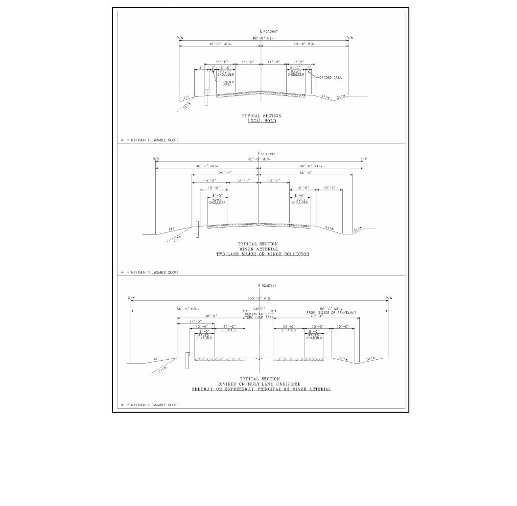
4.1 Plan Submissions. General criteria for a plan submission are summarized as follows:
Plans must comply with DelDOT’s Standards and Regulations for Subdivision Streets and State Highway Access. Construction plans must be signed and sealed by a land surveyor or professional engineer registered in Delaware. It is the engineer’s responsibility to meet the standards and plan requirements. Plan approval does not release the developer’s responsibility to meet the standards. If pavement, geotechnical and/or structural design are included, then a professional engineer registered in Delaware and qualified to perform the design must sign and seal the plans. Exceptions may be permitted at the sole discretion of DelDOT where the proposed development has an average daily traffic generation of less than 100 trips, each vehicle being counted twice (in and out).
The construction stage fee must be paid prior to review of the semi-final plans as outlined in Chapter 1. If the requirements outlined in these Standards and Regulations for Subdivision Streets and State Highway Access are not met by the second semi-final plan submission, then a new application and construction stage fee shall be required prior to further reviews.
The applicant is required to pay National Pollution Discharge Elimination System (NPDES) fees, as outlined in Chapter 1, when DelDOT reviews a stormwater management facility as part of an offsite improvement project where DelDOT has the review and approval authority for the facility. This payment shall be submitted with the preliminary plans.
The maximum plan sheet size shall be 24” x 36”. Larger plan sheets shall be returned without review.
Drafting work shall be neat, legible and reflect locations of existing and proposed features based on actual field surveys. All text height shall be 0.1 times the scale of the plan sheet. All text shall be legible when plans are produced at half size. Entrance geometry and construction details shall be drawn to a scale of 1” = 30' or 1” = 20', with the former being preferable. Where the proposed development has an average daily traffic generation of less than 100 trips, a scale of 1” = 50' may be permitted.
4.1.1 Preliminary Plans. Preliminary construction plans shall be prepared showing the feasibility of constructing a subdivision street system or commercial entrance prior to recording the right-of-way with the land use agency. This plan shall be drawn to a scale of no less than 1” = 100'. The plan shall provide, at a minimum, the following information:
Figure 4.1 Contour Interval for Various Ground Slopes
Average Ground Slope | Contour Interval |
Less than 0.5% | 1.0 feet with spot grades |
0.5% to 5.0% | 1.0 feet |
Over 5% | 2.0 feet |
4.1.2 Semi-Final Plans
Semi-final construction plans shall be reviewed by DelDOT following the “No Objection” letter issued to the land use agency. The plans are to be prepared in accordance with DelDOT requirements. Four complete sets of semi-final construction plans shall be required for the review.
One copy of back-up calculations for design elements outlined in Chapter 5 (i.e., entrance design, sight distance triangles, typical section elements, pavement design, drainage design, and signing and striping) and a complete set of stormwater and sediment/erosion control drawings must be submitted for review with the semi-final plans.
4.1.3 Final Plans
The final construction plans and special provisions must include all revisions required by DelDOT. Final plans must be signed and sealed by a land surveyor or professional engineer registered in Delaware.
For subdivision street construction plan approval, two Mylar sets of the final plans shall be submitted.
For commercial entrance and subdivision entrance construction plan approval in which the subdivision is located within a town or city limits, six paper sets of final plans shall be submitted.
If the developer intends to phase the construction of a fully reviewed subdivision, then two copies of the signed and sealed title sheet, listing the streets to be constructed in a particular phase, shall be submitted along with an application and security that reflects the streets listed on the title sheet. Subsequent phases will be approved in the same manner. Any phased plan will have to meet the current standards and regulations at the time of approval.
4.2 Electronic Plan Submission
DelDOT’s roadway inventory management system tracks information relative to all State-maintained roadways including their location, width, length, drainage features, and signing.
In an effort to keep the system updated, DelDOT requires the following information to be provided to the Development Coordination office prior to acceptance of any subdivision street.
4.2.1 Prior to Construction Plan Approval –
Along with the Mylar construction plans, the developer shall submit an electronic file containing the plan sheets. These plans may be submitted in AutoCAD or Microstation, or pdf format. In order to minimize the required data storage space, DelDOT requires only the construction plan sheet files for projects (e.g., .dwg files). All files shall be purged prior to submittal.
The developer’s engineer shall provide DelDOT with a street map in electronic format. The map, which shall be used for the acceptance drawing, shall include the following information:
4.2.2 Prior to Street Acceptance. The developer’s engineer shall provide DelDOT with an acceptance drawing in an electronic format. As part of the requirement for electronic plan submission, the drawing shall delineate the portion of subdivision streets proposed for acceptance.
4.2.3 Prior to Street Acceptance of the Final Phase of Construction. The developer’s engineer is required to submit the approved as-built construction plan, annotated in red to show all revisions necessitated by field conditions, to the District Engineer or designee prior to the recommendation for acceptance. In addition, the engineer shall also submit an electronic plan version of the as-built construction plan for the entire subdivision to the Development Coordination office. This as-built plan shall replace the original construction plan in the State’s electronic inventory.
4.3 Subdivision Construction Plan Checklist. Any plan submitted to DelDOT for review must contain all elements listed in this section. When a plan is submitted for review, it will be checked to ensure the required elements are on the plan. If any elements are not relevant to the particular site then these elements shall be outlined in the submittal letter. If all elements are not on the plan, the plan will be returned to the engineer for resubmission with no comments provided by DelDOT.
Semi-final and final construction plans shall be prepared in accordance with the following subsections.
4.3.1 Title Sheet. A title sheet shall include the following (see Figure 4.5 for a sample title sheet):
4.3.1.1 Name of subdivision.
4.3.1.2 Section of the subdivision or name of the streets to be considered by this plan.
4.3.1.3 Identification of subdivision streets as public or private (see Section 3.6.2).
4.3.1.4 General location map.
4.3.1.5 County in which subdivision is located.
4.3.1.6 Total sheets in subdivision street construction plan.
4.3.1.7 Plan view of entire subdivision indicating streets to be constructed by this plan and their relation to all other streets within the subdivision. Show north arrow for reference.
4.3.1.8 General Notes (see Appendix J).
4.3.1.9 Index of sheets.
4.3.1.10 Legend of utilities.
4.3.1.11 Signature block.
4.3.1.11.1 Seal of individual properly licensed in Delaware to perform the engineering and design for the preparation of construction plans for subdivision streets.
4.3.1.11.2 Signature of engineer and date.
4.3.1.11.3 Signature block and date for Subdivision Engineer approval. Approval applies only to the section of the subdivision being bonded.
4.3.2 Typical Section Sheets. Typical section sheets are required as part of subdivision construction plans. They are required for each major change of section and shall include the following:
4.3.2.1 Typical Street Sections.
4.3.2.1.1 Width of street, shoulders and right-of-way.
4.3.2.1.2 Cross-slope of pavement, shoulders and side slopes.
4.3.2.1.3 Point-of-Profile Grade Application.
4.3.2.1.4 Type of curb.
4.3.2.1.5 Depth and type of pavement material.
4.3.2.1.6 Locations to place topsoil, seed and mulch.
4.3.2.1.7 Underdrain.
4.3.2.1.8 Subgrade to be prepared in accordance with DelDOT Standard Specifications.
4.3.2.1.9 Existing and proposed right-of-way widths and easements.
4.3.2.2 Typical Lateral Ditches and/or Outfall Ditches.
4.3.2.2.1 Width of ditch bottom.
4.3.2.2.2 Point-of-Profile Grade Application (Ditches longer than 100 feet require a profile).
4.3.2.2.3 Side slopes.
4.3.2.2.4 Type and depth of ditch protection.
4.3.2.2.5 Locations to place topsoil, seed, and mulch.
4.3.3 Detail Sheets. Detail sheets shall provide information to the contractor on construction that is not included in the Standard Construction Details, and shall include the following:
4.3.3.1 Special Details.
4.3.3.1.1 Intersection roads.
4.3.3.1.2 Super-elevation diagrams (when required).
4.3.3.1.3 Details of non-standard drainage structures.
4.3.3.1.4 Driveway details.
4.3.3.2 Intersection Details.
4.3.3.2.1 Intersection radii with station and offsets to curve points.
4.3.3.2.2 Location by station and offset to islands.
4.3.3.2.3 Grade elevations at maximum interval of 25 feet on edge of islands and intersection radii.
4.3.4 Plan Sheet. Plan sheets shall include the following:
4.3.4.1 Horizontal and vertical control data.
4.3.4.1.1 Benchmarks: Maximum spacing is 1000 feet. Show elevation and location. Use NAVD 88.
4.3.4.1.2 Centerline stationing and curve data.
4.3.4.1.3 Survey references to horizontal control points.
4.3.4.1.4 Bearings of centerline tangents.
4.3.4.1.5 Stations of intersecting roads.
4.3.4.1.6 Limits of construction.
4.3.4.1.7 North arrow on each plan sheet.
4.3.4.1.8 Right-of-way line, existing and proposed (dimensioned from centerline of road).
4.3.4.1.9 Right of way monuments.
4.3.4.2 Utilities.
4.3.4.2.1 Location of existing and proposed utility lines including sewer, water, power, communication, and cable. A separate set of utility plan sheets may be required depending on the complexity of the plan sheet.
4.3.4.3 Drainage.
4.3.4.3.1 Location and elevations of parallel ditches every 50 feet.
4.3.4.3.2 Location and type of ditch protection other than seed and mulch.
4.3.4.3.3 Drainage flow arrows on pipes, underdrains, and ditches.
4.3.4.3.4 Identify and locate drainage structures, storm sewers, and culverts with specific identifiers.
4.3.4.3.5 Location, flow line, elevation, typical section and ditch protection for culvert or storm sewer outfall.
4.3.4.3.6 A pipe and drainage structure schedule shall be included on each plan sheet. These schedules shall list the structure ID, type, invert, and top elevation, pipe ID, size, length, invert elevations, slopes and type. See Figures 4.3 and 4.4 for storm drainage structure and pipe schedule.
4.3.4.3.7 Pipe angles shall be listed in the schedule and shall not exceed the maximum values listed in Figures 5-30 thru 5-32.
4.3.4.4 Minimum scale for construction plans is 1” = 50'. Intersection details shall be at 1” = 30'.
4.3.5 Profile Sheet. Profile sheets shall be on same sheet as plan sheets, where possible. Profile sheets shall include the following:
4.3.5.1 Horizontal scale – Horizontal scale shall be same as plan sheet.
4.3.5.2 Vertical scale – Vertical scale shall generally be 1” = 5'.
4.3.5.3 Vertical Curve Data: PVC, PVI, PVT, length of curve, PVI Elevation.
4.3.5.4 Soil information (when available) – Use exaggerated scale and indicate type and depth of material.
4.3.5.5 Drainage features – Identify drainage features with pipe or structure identifier that matches schedule.
4.3.5.6 Existing and proposed utilities.
4.3.6 Maintenance of Traffic
To ensure that traffic control for construction along State-maintained roadways has been addressed on all land development projects, a Maintenance of Traffic (MOT) plan must be submitted and approved prior to final construction plan approval by the Subdivision Engineer. All MOT plans shall be developed in accordance with the “Traffic Controls for Streets and Highway Construction, Maintenance, and Utility Operations” hereafter referred to as DelDOT’s Traffic Control Manual Delaware MUTCD and shall be submitted to the Subdivision Engineer with the construction plans. The MOT plans shall be reviewed and approved by the District Safety Officer as part of DelDOT’s internal review process.
A MOT plan must be prepared for all projects. Depending on the complexity of the project, the plan may range from a short narrative including the MOT case diagram and its associated case notes in the DelDOT Traffic Control Manual Delaware MUTCD on the plans to a series of sheets detailing the traffic control measures for phased construction as directed by DelDOT. See Appendix J for General Notes for MOT.
A copy of the MOT plan approval letter shall be required to be on the construction site at all times.
At a proposed entrance that requires widening to the existing State-maintained roadway, spot elevations on the proposed edge of pavement and where the proposed pavement meets the existing pavement shall be provided at 25-foot intervals. Spot elevations at the entrance radii shall be given at ten-foot intervals. Corresponding elevations of the existing ground, at the edge of proposed pavement, shall also be provided to assess the proposed cut and fill depth.
4.3.7 Entrance Plan. Entrance plans shall include the following:
4.3.7.1 Property lines.
4.3.7.2 Existing and proposed right-of-way.
4.3.7.3 Existing and proposed easements.
4.3.7.4 Names of abutting land owners.
4.3.7.5 Planimetric features.
4.3.7.6 Existing grade contours.
4.3.7.7 Proposed finished grade contours.
4.3.7.8 Location of any crossovers.
4.3.7.9 Roadway curves.
4.3.7.10 Existing and proposed entrances serving the adjacent properties. (See Figure 3-1).
4.3.7.11 Proposed sight distance easements.
4.3.7.12 Existing drainage features.
4.3.7.13 Location of existing and proposed buildings.
4.3.7.14 Parking layout.
4.3.7.15 Proposed site drainage.
4.3.7.16 Proposed entrance geometry.
4.3.7.17 Entrance construction details.
4.3.7.18 Typical sections showing the following proposed and existing information:
4.3.7.19 Proposed limit of construction.
4.3.7.20 Existing roadway lane widths and striping.
4.3.7.21 Dimensions for all entrance radii.
4.3.7.22 Existing and proposed utility poles, signs, etc.
4.3.7.23 North arrow.
4.3.7.24 Site generated ADT and distribution (per the latest edition of the ITE Trip Generation).
4.3.7.25 Mainline ADT (existing and projected) and speed limit.
4.3.7.26 Signing and striping plan.
4.3.7.27 Existing signal equipment.
4.3.8 Cost Estimate
Following the approval of the final construction plan, a cost estimate for the intended street construction shall be prepared using the cost per linear foot (lf) of roadway being constructed. A separate cost estimate shall be prepared for entrance improvements and shall be provided to DelDOT for review. Each item of construction shall be listed in accordance with DelDOT’s Standard Specifications. The method of measurement for each item shall be in accordance with the Standard Specifications and a current unit price shall be supplied for each item.
The itemized construction cost estimate shall be broken down to provide sufficient detail to allow DelDOT to establish the accuracy and completeness of the estimate. Each material shall be accounted for as a separate item in the estimate as illustrated below.
DelDOT, as part of the review, shall approve all the costs estimates. These estimates shall be used to determine the security required for each part of construction.
Figure 4.2 Itemized Cost Estimate Example
Item | Quantity | Unit Cost | Total Cost |
Concrete Curbing, Type 2 | 15,000 l.f. | $20.00 per l.f. | $300,000.00 |
Hot-mix, Type B | 2,500 tons | $38.00 per ton | $95,000.00 |
Figure 4.3 Storm Drainage Structure Schedule
Name | Description | T.G. Elev. | Invert In | Invert In | Invert In | Invert Out | Pipe Angle | Pipe Angle | ||
Box | Top Unit | Grate | ||||||||
Figure 4.4 Storm Drainage Pipe Schedule
Pipe | Description | Invert Elevation | |||||||
From | To | Size | Type | Length | Class | Slope (%) | In | Out | |
4.4 Commercial Entrance Plan Checklist
Any plan submitted to DelDOT for review must contain all elements listed in this section. When a plan is submitted for review, it will be checked to ensure the required elements are on the plan. If any elements are not relevant to the particular site then these elements shall be outlined in the submittal letter. If all elements are not on the plan, the plan will be returned to the engineer for resubmission with no comments provided by DelDOT.
This section also applies to the requirements for private subdivision entrances onto State-maintained roadways.
4.4.1 Title sheets shall include the following:
4.4.1.1 A title block containing:
4.4.1.1.1 Name of proposed business.
4.4.1.1.2 Name of nearest town or county.
4.4.1.1.3 Maintenance number of roadway being accessed.
4.4.1.1.4 Graphic scale (1” = 30' preferred, 1” = 20' acceptable). Scaled drawing of the project.
4.4.1.1.5 Date.
4.4.1.1.6 Name, address and telephone number of engineer or surveyor preparing plan.
4.4.1.1.7 Seal of engineer or surveyor (Delaware license required).
4.4.1.2 A data block containing:
4.4.1.2.1 Type of business.
4.4.1.2.2 Gross acreage of property.
4.4.1.2.3 Approximate gross leasable floor plan.
4.4.1.2.4 Traffic generation (ADT) with trip distribution shown.
4.4.1.2.5 Peak hour traffic distribution in terms of vehicles per hour (vph).
4.4.1.2.6 Parking spaces required.
4.4.1.2.7 Parking spaces furnished.
4.4.1.2.8 Local government responsible for land use approval.
4.4.1.3 A 1” = 800' key map measuring six square inches, with all crossroads clearly marked. General location map.
4.4.1.4 A North arrow.
4.4.1.5 General Notes (see Appendix J).
4.4.1.6 Sheet index with total sheet count.
4.4.2 Entrance plans shall include the following:
4.4.2.1 Property lines.
4.4.2.2 Existing and proposed right-of-way.
4.4.2.3 Existing and proposed easements.
4.4.2.4 Names of abutting land owners.
4.4.2.5 Planimetric features.
4.4.2.6 Existing grade contours.
4.4.2.7 Proposed finished grade contours.
4.4.2.8 Location of any crossovers.
4.4.2.9 Roadway curves.
4.4.2.10 Existing and proposed entrances serving adjacent properties.
4.4.2.11 Proposed sight distance easements.
4.4.2.12 Existing drainage features.
4.4.2.13 Location of existing and proposed buildings.
4.4.2.14 Parking layout.
4.4.2.15 Proposed site drainage.
4.4.2.16 Proposed entrance geometry.
4.4.2.17 Entrance construction details.
4.4.2.18 Typical sections showing the following proposed and existing information:
4.4.2.19 Proposed limit of construction.
4.4.2.20 Existing roadway lane widths and striping.
4.4.2.21 Dimensions of all entrance radii.
4.4.2.22 Existing and proposed utility poles, signs, etc. utilities.
4.4.2.23 North arrow. Graphic scale (1” = 30’ preferred, 1” = 20’ acceptable).
4.4.2.24 Site generated ADT and distribution (per the latest edition of the ITE Trip Generation).
4.4.2.25 Mainline ADT (existing and projected) and speed limit.
4.4.2.26 Signing and striping plan. (A separate sheet may be required)
At a proposed entrance that requires widening to the existing State-maintained roadway, spot elevations on the proposed edge of pavement and where the proposed pavement meets the existing pavement shall be provided at 25-foot intervals. Spot elevations at the entrance radii shall be given at 10-foot intervals. Corresponding elevations of the existing ground, at the edge of proposed pavement, shall also be provided to assess the proposed cut and fill depth. The proposed spots along a curb line should show top and gutter line of curb.
4.4.3 Maintenance of Traffic
To ensure that traffic control for construction along State-maintained roadways has been addressed on all land development projects, a Maintenance of Traffic (MOT) Plan must be submitted and approved prior to final construction plan approval by the Subdivision Engineer. All MOT plans shall be developed in accordance with the DelDOT Traffic Control Manual Delaware MUTCD and shall be submitted to the Subdivision Engineer with the construction plans. The MOT plans shall be reviewed and approved by the District Safety Officer as part of DelDOT’s internal review process.
MOT plans must be prepared for all projects. Depending on the complexity of the project, the plan may range from a short narrative and with a reference to a case number in the DelDOT Traffic Control Manual to a series of sheets detailing the traffic control measures for a phased construction as directed by DelDOT.
A copy of the MOT approval letter shall be required to be on the construction site at all times.
4.4.4 Cost Estimate
Following the approval of the final construction plan, a cost estimate for the entrance improvements shall be prepared and shall be provided to DelDOT for review. Each item of construction shall be listed in accordance with DelDOT’s Standard Specifications. The method of measurement for each item shall be in accordance with the Standard Specifications and a current unit price supplied for each item.
The itemized construction cost estimate shall be broken down to provide sufficient detail to allow DelDOT to establish the accuracy and completeness of the estimate. Each material shall be accounted for as a separate item as illustrated in Figure 4.2.
DelDOT, as part of the review, shall approve all the costs estimates. These estimates shall be used to determine the security required for each part of construction.
4.5 Off-Site Improvement Plans
The developer’s engineer shall prepare and submit to DelDOT for review and approval all right-of-way plans, construction plans, specifications, and estimates for the project as outlined in the Off-site Improvement Agreement described in Section 3.10.2. All required submissions to internal DelDOT support sections shall be made to the Development Coordination Section and then shall be distributed throughout DelDOT in accordance with these regulations. The engineer shall design the project in accordance with the American Association of State Highway and Transportation Officials (AASHTO) A Policy on Geometric Design of Highways and Streets, DelDOT Standards Specifications, Policies, and Practice. The engineer shall notify DelDOT in writing of any conflicts with AASHTO or DelDOT Design Standards, Specifications, Policies or Practice. Plan presentation should comply with the model plans that are available on www.DelDOT.gov.
In instances where the engineer determines that it is not in the best interest of the project traveling public to comply with these standards, the engineer shall provide to DelDOT a written justification and rationale for their decision. DelDOT shall have the final authority on any process modifications or design exceptions.
The plan submissions will consist of a preliminary, semi-final, and final (or contract) plan submission. The engineer shall establish review dates with concurrence from DelDOT. The submittals shall include design plans, specifications and cost estimates for construction of the project.
The engineer shall coordinate with the utility companies to determine existing facility locations and to start the discussions on possible relocations.
Existing deeds, plot plans and existing roadway plans shall be used to establish and verify the existing right-of-way. The engineer is responsible for attesting to the right-of-way shown on the plans.
The engineer will work through the Development Coordination Section and the Pavement Management Section for pavement evaluation and design verification. This may include pavement cores and subgrade soils analysis. The engineer will work with Design Services for hazardous material/contaminated site delineation.
The engineer will work with Design Services on identifying environmental or cultural resources that are present within the existing and/or proposed right-of-way. The engineer shall prepare, apply for, and obtain all necessary permits and environmental or historic documentation required by federal, state, and local authorities. Copies of the permits and supporting documentation shall be provided to DelDOT prior to final plan approval.
DelDOT will provide assistance in identifying but not obtaining all necessary permits and coordination for off site road improvements. The following, but not limited to, may be required to construct the off-site improvements:
4.5.1 Preliminary Construction Plans (See Checklists in Apendix D)
4.5.1.1 Preliminary construction plans shall include the following:
4.5.1.1.1 Title sheet.
4.5.1.1.2 Plan sheet index.
4.5.1.1.3 Notes and legend sheet.
4.5.1.1.4 Typical sections.
4.5.1.1.5 Horizontal and vertical control.
4.5.1.1.6 Construction plan with proposed design (including conceptual drainage layout and clear zone).
4.5.1.1.7 Existing and proposed profile including existing drainage.
4.5.1.1.8 Grades and Geometrics showing where coordinates are to be given (edge of gutter, begin/end of transitions, and critical curve points) for proposed geometrics and tick marks where grades will be given (edge of gutter in intersections, super-elevation transitions, and critical points).
4.5.1.1.9 Conceptual stormwater management or a waiver from the SWM Engineer.
4.5.1.1.10 Construction details.
4.5.1.1.11 Conceptual construction phasing, detailed enough for discussion and brainstorming.
4.5.1.1.12 Conceptual environmental compliance plan,
4.5.1.1.13 Lighting plans (including proposed pole locations).
4.5.1.1.14 Signing and striping and coordination conduit plans with proposed striping and existing signs shown.
4.5.1.1.15 Signalization plans (including proposed signal pole locations).
4.5.1.2 The developer’s engineer shall ensure proper coordination with appropriate agencies. The preliminary construction plans shall be reviewed by the following stakeholders:
4.5.1.2.1 To utility companies for overhead facility relocation design (to determine real estate needs), and underground facility conflict review. Based upon extent of underground utility conflicts and coordination with Utilities Section, request appropriate number of utility test pits and designation where necessary through Utilities Section. Also, provide locations and approximate depths of large cuts and fills.
4.5.1.2.2 To Stormwater Engineer for review and comment.
4.5.1.2.3 To Traffic for review and comment pertaining to signal design, proposed signing, and striping, and detour plan consideration.
4.5.1.2.4 To Construction for overall plan review and comment.
4.5.1.2.5 To Roadside Development Administrator to determine tree replacement requirements and subsequent real estate needs. The engineer shall coordinate tree impact and mitigation analysis with a landscape architect.
4.5.1.2.6 To Design Services for documentation of proposed impacts to environmental and cultural resources. The engineer should also keep Design Services aware of all correspondence that has occurred between the resource agencies and the developer.
4.5.1.3 Continued coordination with affected utility companies is required at this stage. Projects that require overhead utility relocation must have the location of relocated facilities soon after the preliminary plan submission. This is required so the proper amount of real estate can be acquired or dedicated to facilitate the relocation, and coordination of these facilities can be coordinated with other aerial items such as signal poles and light poles. It is also imperative that the utility test hole information be analyzed to determine which underground utility conflicts cannot be avoided. Once it is determined that it is not possible to avoid the utility conflict, the affected utility company needs to be informed as soon as possible so underground relocation design can commence. If underground relocation will impact real estate needs, it should be identified at this time. It should also be noted that any conflicts that arise after preliminary plan submittal, as the result of a design change, should be brought to the attention of the affected utility company as soon as it is identified.
4.5.1.4 For projects with complex maintenance of traffic issues, a coordination meeting should be held with Construction and Traffic (including the Safety Section) to receive their input.
4.5.1.5 Depending on complexity of project, at least one Design Public Workshop will typically be held soon after the preliminary plan submittal.
4.5.1.6 The Subdivision Engineer should allow no less than 4530-days review time from the date of submittal.
4.5.2 Semi-Final Construction Plans (95%)
4.5.2.1 Semi-final construction plans (95%) shall include the following:
4.5.2.1.1 Title sheet.
4.5.2.1.2 Plan sheet index.
4.5.2.1.3 Notes and legend sheet.
4.5.2.1.4 Typical sections.
4.5.2.1.5 Horizontal and vertical control.
4.5.2.1.6 Construction plan with final proposed design (including final drainage with pipe sizes and inverts).
4.5.2.1.7 Existing and proposed profile including existing and proposed drainage, underground utilities with test hole data, soil boring, and test holes plotted.
4.5.2.1.8 Grades and geometrics with final geometrics and grades.
4.5.2.1.9 Semi-final stormwater management plans and report or a waiver from the SWM Engineer.
4.5.2.1.10 Construction details.
4.5.2.1.11 Construction phasing, M.O.T., and erosion control plans (with semi-final utility construction phasing taken into account).
4.5.2.1.12 Detour plans.
4.5.2.1.13 Final Environmental Compliance Plan.
4.5.2.1.14 Lighting plan.
4.5.2.1.15 Landscaping plan.
4.5.2.1.16 Utility relocation plans (overhead utility relocations required; with underground facility relocation design when possible. Where underground facility relocation impacts real estate needs, horizontal location is required).
4.5.2.1.17 Signing and striping and coordination conduit plans with final striping and proposed signs and sign locations shown (including final sign structure locations).
4.5.2.1.18 Signalization plans.
4.5.2.1.19 Semi-final cross sections (existing surface, proposed surface, LOC, existing and proposed right-of-way, clear zones).
4.5.2.2 The developer’s engineer shall ensure proper coordination with appropriate agencies: The semi-final construction plans shall be reviewed by the following stakeholders:
4.5.2.2.1 To Stormwater Engineer with Semi-final Stormwater Report for review and comment.
4.5.2.2.2 To Construction with marked up Semi-final special provisions for review and comment.
4.5.2.2.3 To Traffic for review and comment.
4.5.2.2.4 To Specifications Engineer for review and comment.
4.5.2.2.5 To Roadside Development Administrator to ensure proper selection of tree types for replacement policy.
4.5.2.2.6 To Design Services for documentation of proposed impacts to environmental and cultural resources. Any permits that have been issued shall be made available to the Design Services Section.
4.5.2.2.7 Other submittals are to be made to the following for general review and comment: Materials and Research, Quality Section, Chief Safety Inspector, Bicycle/Pedestrian Coordinator, Architectural Accessibility Board (for approval), DTC, Chief Engineer and others as determined by the Subdivision Engineer.
4.5.2.2.8 To utility companies for final utility relocation design. Coordination will occur with the Quality Section to determine the construction time necessary for the project taking into account the time detailed in the final utility statements. The construction sequencing bar charts will be updated and ultimately included in the final advertisement package.
4.5.2.3 The Subdivision Engineer should allow no less than 4530-days review time from the date of submittal.
4.5.2.4 Semi-Final Right-of-Way Plans
Semi-Final Right-of-Way plans shall be developed in accordance with the DelDOT standards. These plans will be submitted for review to Design Support. The Design Support Section shall review these plans from a technical perspective as well as attesting to the need based on the design parameters established during the initial project scoping. The following section lists the requirements for semi-final right-of-way plans.
The following section lists the requirements for semi-final right-of-way plans.
4.5.3 Final Construction Plans (100%). The Subdivision Engineer should allow no less than 4530-days review time from the date of submittal.
4.5.3.1 Final construction plans (100%) shall include the following:
4.5.3.1.1 Title sheet (signed and sealed).
4.5.3.1.2 Plan sheet index.
4.5.3.1.3 Notes and legend sheet.
4.5.3.1.4 Typical sections.
4.5.3.1.5 Horizontal and vertical control.
4.5.3.1.6 Final construction plan.
4.5.3.1.7 Existing and proposed profile including existing and proposed drainage, underground utilities, soil boring, and test holes plotted.
4.5.3.1.8 Grades and Geometrics with final geometrics and grades.
4.5.3.1.9 Final stormwater management plans and report.
4.5.3.1.10 Construction details.
4.5.3.1.11 Construction phasing, M.O.T., and erosion control plans (with utility construction phasing included).
4.5.3.1.12 Detour plans.
4.5.3.1.13 Lighting plan.
4.5.3.1.14 Landscaping plan.
4.5.3.1.15 Utility relocation plan.
4.5.3.1.16 Final signing and striping and coordination plans.
4.5.3.1.17 Signalization plans.
4.5.3.1.18 Final cross sections (existing surface, proposed surface and box, LOC, existing and proposed right-of-way, clear zone, existing and proposed drainage, relocated and proposed utilities).
4.5.3.2 The developer’s engineer shall also submit final construction plans to the following and make proper coordination with appropriate agencies:
4.5.3.2.1 To Stormwater Engineer with final Stormwater Report.
4.5.3.2.2 Construction
4.5.3.2.3 Utilities
4.5.3.2.4 Traffic
4.5.3.3 Final right-of-way plans shall include the following:
See Appendix D for the right-of-way plan checklist.
The right-of-way plans will remain in the semi-final status until all comments from the Design Support Section have been addressed. Once the final right-of-way plans meet all the established criteria they shall be approved as to process by the Subdivision Engineer, the Manager of the Design Support Section and the Assistant Director-Design.
4.5.4 Cost Estimate
Following the approval of the final construction plan, a cost estimate for the roadway improvements shall be prepared and shall be provided to DelDOT for review. Each item of construction shall be listed in accordance with DelDOT’s Standard Specifications. The method of measurement for each item shall be in accordance with the Standard Specifications and a current unit price supplied for each item.
The itemized construction cost estimate shall be broken down to provide sufficient detail to allow DelDOT to establish the accuracy and completeness of the estimate. Each material shall be accounted for as a separate item as illustrated in Figure 4.2.
DelDOT, as part of the review, shall approve all the costs. These estimates shall be used to determine the security required for each part of construction.
4.6 Industrial park streets shall follow the standard construction plan development procedure, as previously outlined in Section 4.3.
4.7 Standards and Specifications
4.7.1 Standards
DelDOT has developed Standard Construction Details to provide consistency on State-maintained projects. Standard Construction Details may be purchased from DelDOT and are also available on DelDOT’s website (www.DelDOT.gov).
The Standard Construction Details shall be utilized in the construction unless there is some unusual circumstance requiring a special design. The plans shall show construction details only for those construction elements not shown in the Standard Construction Details.
If there are engineering elements including but not limited to, structural designs required on a plan that are not included in the Standard Construction Details then detailed engineering shop drawings signed and sealed by a professional engineer shall be submitted to DelDOT for review and approval. All structural elements shall be designed in accordance with AASHTO LRFD Bridge Design Manual (latest revised edition). DelDOT’s Bridge Section will have the review and approval authority.
The project shall be constructed using the latest revised Standard Construction Details in effect at the date of Notice to Proceed.
4.7.2 Specifications
Specifications for frequently used construction items have been prepared by DelDOT. Copies of these Standard Specifications may be purchased from DelDOT or are available online at (www.DelDOT.gov).
The construction of subdivision streets shall be in accordance with the current DelDOT Standard Specifications. Should it be necessary to construct an item for which a standard does not exist or where it is desired to modify the Standard Specifications, special provisions shall be developed to provide the contractor the necessary information to construct the item. These special provisions as well as any other relevant information shall be bound and submitted with the final construction plans for review and approval.
The project shall be constructed using the latest revised Standard Specifications in effect at the date of Notice to Proceed, and the special provisions, as approved by DelDOT.
4.7.3 Special provisions shall be a bound document included as part of the final plan submission. This document shall include direction to the contractor on items that are not found in the Standard Specifications. These items may include, but not limited to, easements, environmental permits, special record plan notes, and TIS recommendations, and agreements. This document may also include additional information, as requested by DelDOT, to assist in the implementation of the construction.
4.8 Stormwater Management
DelDOT will work cooperatively with regulating agencies responsible for enforcing Delaware Sediment and Stormwater Regulations (DSSR) to ensure stormwater is adequately controlled. These agencies include Delaware Department of Natural Resources and Environmental Control (DNREC), New Castle County Land Use Engineering, New Castle County Conservation District, Kent Conservation District (KCD), and Sussex Conservation District (SCD).
Stormwater management shall meet State regulations in terms of quality and quantity as outlined in the Erosion and Sediment Control Stormwater Management (ES2M) Design Guide.
Stormwater management shall be designed for all existing and proposed roadway work and total project runoff including roadway runoff shall be managed by a private stormwater management facility.
When determining the need for stormwater management, the impervious areas added to the existing State-maintained roadway shall be considered. If stormwater management is required it shall be managed by a private stormwater management facility. The area of the entrance construction shall be included in the analysis and clearly documented in the stormwater report.
When the proposed development is limited to the site and the entrance, the review of design and construction of stormwater management facility is performed by a non-DelDOT delegated agency for DSSR enforcement. In this case, the non-DelDOT delegated agency shall attest that the DSSR within DelDOT right-of-way have been met and shall be documented in a memo and forwarded to DelDOT’s Stormwater Engineer for files.
If the proposed roadway work is not contiguous with the land development proposal, the review of design and construction of stormwater management facility shall be performed by DelDOT’s ES2M for DSSR enforcement. The Stormwater Engineer will sign the plans upon determination of full compliance of the plans and reports with the requirements of DSSR indicating that the plans meet the requirements of State and Federal stormwater laws. DelDOT’s ES2M shall require 30 calendar days to review the plans and stormwater management report.
Plans for review shall be developed in half size (11”x17”) and arranged similar to DelDOT plans for consistency and ease of review. Section 1 of ES2M Design Guide contains a checklist which shall be completed and submitted with the plans along with a transmittal memo requesting the plans to be reviewed by DelDOT.
The stormwater management report shall be required in order to assess conformance with the provisions of DSSR. Section 2 of ES2M Design Guide describes the content of organization of the report that shall be followed.
4.8.1 The following shall also apply to all site designs:
4.8.1.1 Stormwater facilities, excluding bioswales, shall be located a minimum of 20 feet from the State right-of-way.
4.8.1.2 Any stormwater management pond shall be designed so that the invert of all inlet pipes is above the normal pool elevation. Exceptions to this requirement will only be considered if requested in writing with supporting documentation. In no case shall the normal pool elevation exceed the invert of the nearest drainage inlet.
4.8.1.3 DelDOT shall not allow the outflow from stormwater management ponds to discharge into the State right-of-way if there is the ability to discharge the run-off to a different location.
4.8.1.4 Where the outfall for any stormwater management pond outlets onto the State right-of-way, a detailed hydraulic and stormwater analysis shall be required to determine the impacts to the roadway drainage system and to ensure stormwater impacts for surrounding property owners is minimized (see Section 5.7).
4.8.1.5 If there is an identified drainage problem and the proposed site will impact the problem area, the applicant shall contribute towards mitigation through management of stormwater, wherever possible.
Figure 4.5 Sample Title Sheet
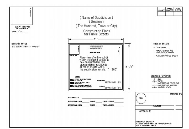
5.1 Geometric Design of Subdivision Streets
5.1.1 General
The design of subdivision streets is to be in accordance with the latest standards published by the American Association of State Highway and Transportation Officials (AASHTO), DelDOT’s Road Design Manual, DelDOT’s Bridge Design Manual, DelDOT’s Design Guidance Memorandums and DelDOT’s Standards and Regulations for Subdivision Streets and State Highway Access. Where conflicts exist, DelDOT’s Standards and Regulations for Subdivision Streets and State Highway Access shall take precedence.
In instances where the engineer determines that it is not in the best interest of the traveling public to comply with these standards, the engineer shall provide to DelDOT a written justification and rationale for their decision. DelDOT shall have the final authority on any process modifications or design exceptions.
The street layout of a subdivision has the following elements that must be considered by the developer:
5.1.2 Design Criteria for Subdivision Streets. The Design criteria for subdivision streets shall be in accordance with Figure 5-2.
5.1.3 Intersection Design of Subdivision Streets. The intersection design of subdivision streets shall be in accordance with the following:
5.1.3.1 The corner radii of internal subdivision streets shall meet the requirements of Figure 5-1. The use of larger radii may be considered if there is a need to accommodate larger vehicles. Any entrance for a new subdivision shall meet the requirements of Section 5.2
Figure 5.1 Intersection Design Radii
Intersection of Subdivision Street | Radii | |
Type I | Type I | 15 feet |
Type I | Type II | 20 feet |
Type II | Type II | 25 feet |
Type II | Type III | 25 feet |
Type III | Type III | Set to meet design vehicle |
5.1.3.2 Street profiles within 40 feet of the nearest edge of pavement of the intersection may not exceed 5% to provide for sight distance.
5.1.3.3 90o intersections are preferred. Intersection angles less than 70o are not permitted.
5.1.3.4 The distance required to remove the roadway crown at an intersection is to be established using a maximum relative slope between the profiles of the edge of pavement and centerline of one foot in 150 feet. The roadway crown of the major street is to be maintained.
5.1.3.5 Signing and striping shall be in accordance with Delaware MUTCD as adopted by DelDOT.
5.1.3.6 Roundabouts may be used for intersection design within subdivisions. The design shall conform to the standards outlined in the FHWA publication: "Roundabouts: an Informational Guide." At a minimum, the roundabouts shall include a center island, truck apron and splitter islands on all approaches.
Figure 5.2 Design Criteria for Subdivision Streets
Type of Subdivision | Design Speed | Sight Distance* | Maximum Grades** | Minimum Horizontal Radii | Minimum K-Value Sag Crest |
Type I (< 500 ADT) | 25 mph | 150 feet | 10% | 150 feet | 0.26 0.12 |
Type II (501 - 3000 ADT) | 30 mph | 200 feet | 8% | 300 feet | 0.37 0.19 |
Type III (> 3000 ADT) | 35 mph | 225 feet | 7% | 500 feet | 0.49 0.29 |
Industrial Streets | 35 mph | 225 feet | 7% | 500 feet | 0.49 0.29 |
* Sufficient right-of-way dedicated to the public use shall be provided to maintain the required line-of-sight.
** Maximum street grades can be waived on an individual basis subject to DelDOT’s engineering judgment with respect to the severity of the topography. Minimum street grades should be 0.5%.
Notes:
1. Vertical curves will not be required on streets with an algebraic grade difference of equal to or greater than one percent (1%)
2. Deviations from these criteria shall only be considered if presented in writing and if it has been proven to the satisfaction of DelDOT that the required criteria cannot be met.
5.1.4 Dead End Streets
5.1.4.1 Permanent Dead End Streets
The use of cul-de-sac and other closed end street situations is to be limited to those situations where the developer’s engineer can justify that full street extensions are not possible based on topography, preexisting development or environmental constraints.
Cul-de-sacs must be incorporated in the design of all permanent dead end streets except those eligible to be constructed within a reduced right-of-way. The minimum design criteria for cul-de-sacs are:
5.1.4.1.1 Design radii shall be in accordance with Figure 5-3.
5.1.4.1.2 Base material for cul-de-sacs is to extend a minimum of two feet beyond the edge of paving when an open drainage design is utilized (no curbs).
5.1.4.1.3 The maximum length for a permanent dead end street is 200 feet measured from the radius return to the start of the cul-de-sac. DelDOT may consider longer lengths if the intent of Sect. 3.5 is met.
Figure 5.3 Design Radii for Cul-de-Sacs
Radius* | Cul-de-sacs | Cul-de-sacs with Center Islands |
Right-of-Way | 50 feet | 60 feet |
Outside Edge of Pavement | 38 feet | 46 feet |
Center Island | N/A | 24 feet |
* Measured to the face of curb. | ||
5.1.4.1.4 Developers planning streets with reduced right-of-way should select one of the turn-around designs shown in Figure 5-4 in lieu of the standard cul-de-sac. Any alternative design must have prior approval of DelDOT.
5.1.4.2 Temporary Dead End Streets
Temporary dead end streets shall be constructed to the property line of the development in order to provide for future development of adjacent lands. A temporary turn around must be provided when the length of a temporary dead end street exceeds 200 feet. The additional right-of-way needed to accommodate a temporary turn around can be provided through a temporary easement which must be clearly labeled on the site plan. If the street segment is accepted for State maintenance, DelDOT will maintain the temporary dead end street in accordance with Section 3.6.3.
Based on anticipated future development and flow patterns, those streets with more than 500 ADT upon completion of the initial phase development plus the future development must be designed to the appropriate subdivision street level with the corresponding right-of-way width.
If the temporary dead end street shall ultimately provide connectivity to the adjacent property, the following shall apply:
Figure 5.4 Design Alternatives in lieu of Cul-de-Sacs in Reduced Right-of-Way
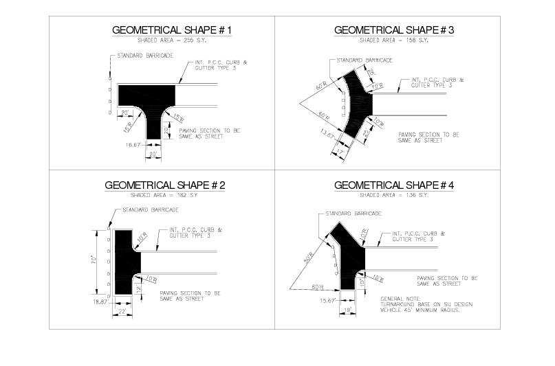
Figure 5.5 Stub Street Signs – Barricade Detail
(Not to Scale)
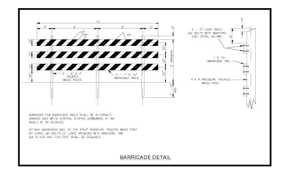
Figure 5.6 Stub Street Signs - Post and Rails
(Not to Scale)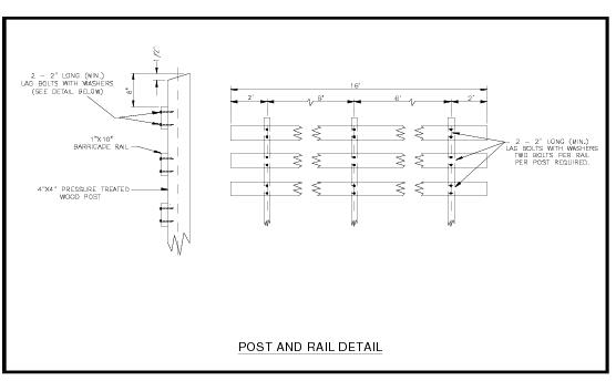
Figure 5.7 Stub Street Signs Detail
(Not to Scale)
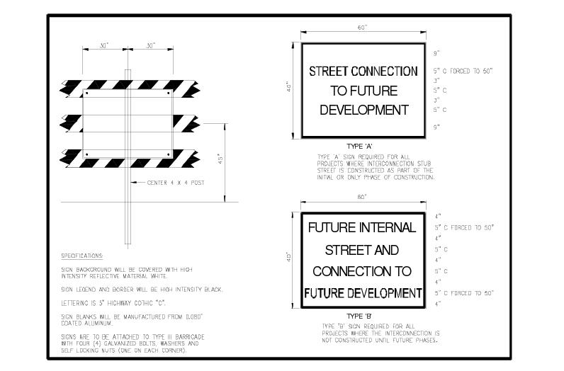
5.1.5 Sidewalks
Sidewalks are an integral part of DelDOT’s infrastructure program. They facilitate and encourage safe and convenient pedestrian travel within communities and among different land uses. They provide safe and reasonable access to public transportation and other alternative modes of transportation, thereby helping alleviate vehicular traffic and reduce emissions. They also reinforce the Americans with Disabilities Act (ADA) by increasing the access opportunity for mobility-impaired individuals. DelDOT requires all subdivision streets to have sidewalks.
All sidewalks and curb ramps are subject to ADA compliance.
5.1.5.1 Placement
In establishing the location of sidewalks, consideration must be given to drainage facilities, sideslopes, new traffic control and signing devices, intersection crossovers, striping, utility appurtenances, mailboxes with posts, and transit stops, in order to avoid conflicts in the design.
For new sidewalks, a minimum width of five feet, not including the width of the top of curb, is required. Wider sidewalks may be preferred or required by local ordinance depending upon the volume and nature of two-way pedestrian traffic. Narrower sidewalks may be allowed subject to consistency with ADA requirements, and surrounding roadside or geographic constraints. A cross slope of 1% is required, with 2% being the maximum.
A buffer between the sidewalk and curb shall be considered. For increased user safety, sidewalks should be as far away from travel lanes as practical. A buffer width of at least five feet between the edge of a sidewalk and the edge of a shoulder, curb, or traveled way is preferred. A five-foot wide strip improves safety, driver comfort, and provides an area for snow removal and mailbox posts.
5.1.5.2 Material
Standard material for any sidewalk or walkway is usually Portland Cement Concrete. However, sidewalk or walkway materials are not limited to Portland Cement Concrete. Upon approval, and when funding is available, more aesthetic materials such as brick, asphalt, or other stable, firm, slip resistant material surfaces may be used. In addition, alternative paving materials that are environmentally sensitive and reduce impervious areas may be used.
Minimum thickness can vary according to materials, but must be at least four inches for Portland Cement Concrete (PCC) on four inches of graded aggregate base course (GABC). A minimum thickness of six inches of PCC and six inches of GABC is required at entrance and driveway areas.
5.1.5.3 Ramps
At intersections, paired perpendicular curb ramps are preferred because they provide an accessible route to enter the crosswalk perpendicular to the travel lane. Single ramps at the intersection radius may only be used in exceptional circumstances, and shall not place the user at risk and shall require prior DelDOT approval. A 24 inch long strip of detectable warnings (truncated domes) shall be placed along the full width of the ramp at the transition to the street.
Curb ramps should be sited and oriented to achieve maximum visibility and orientation to the pedestrian path of travel. Driveway entrances should be designed to minimize excessive cross slopes. When a turn must be made to enter or exit a ramp, level landings at the top and bottom of ramps of five feet in width are preferred, with a minimum width of four feet are required.
For more guidance on sidewalks and curb ramps refer to DelDOT’s Road Design Manual.
5.1.6 Shared Use Path
A shared use path is a facility that is physically separated from the roadway and intended for exclusive use of modes other than motorized vehicles. Initially perceived as bicycle paths, these facilities have grown in popularity, serving bicyclists, in-line skaters, roller skaters, wheelchair users, and pedestrians, including, walkers, runners, people with baby strollers, people walking dogs, etc.
These facilities shall be designed in accordance with the Americans with Disabilities Act standards for shared transportation paths.Maximum slope, cross slope and the rate of change in grade shall be carefully examined during the design process. Because of their multi-use attraction they are a valuable addition to the roadway system and to the range of facilities available to planners and engineers seeking to improve conditions and increase options for all categories of travelers. They can serve both a transportation and recreational function and have proven to be a significant generator of bicycle use. Figure 5-8 shows a layout for a typical two-way shared use path.
Guidance for signing and pavement marking of shared use paths is shown in the Delaware MUTCD and the AASHTO publications.
5.1.6.1 Design Criteria
Refer to the DelDOT Road Design Manual for the design criteria for shared use paths.
A shared use path should be adequately separated from nearby roadways to prevent operational problems that inconvenience path users. The desirable separation of a shared use path from a roadway is ten feet. The minimum separation of a shared use path from the pavement is five feet. When this minimum is not possible, a crashworthy barrier with a railing system at least 44 inches high should be provided. Refer to AASHTO’s Guide for the Development of Bicycle Facilities for more guidance.
Two-way shared use paths should be at least 10 feet wide. In high use areas it is recommended to increase the width to 12 feet. A cross slope of 1% is required with 2% being the maximum.
5.1.6.2 Intersections
Intersections with roadways are important safety considerations in shared use path design. There are three basic types of path-roadway intersections: mid-block, adjacent path and complex. If alternate locations are available, the one with the most favorable intersection conditions should be selected.
Mid-block crossings should be located far enough from the intersection to remain outside of the vehicular traffic mix approaching and entering an intersection. If the use of a mid-block crossing is the only option, then a neck-down or curb extension should be considered.
Adjacent path intersections occur when the path is parallel to a roadway and it crosses a driveway or other intersecting roadway such as a T-intersection or a simple four-legged intersection. In designing this type of crossing, it is important to keep the location close to the intersection. This allows the motorist and path user to recognize they are a part of the traffic mix and to be prepared to react accordingly. In this situation, the user is faced with multiple conflicts.
Complex intersections are site-specific and need to be designed to meet the unique issues associated with them.
When shared use paths terminate at existing roads, it is important to integrate the path into the existing system of roadways. Care should be taken to properly design the terminals to transition the traffic into a safe merging or diverging situation. Appropriate signing is required per Delaware MUTCD to warn and direct both bicyclists and motorists regarding these transition areas. Bicycle path intersections and approaches should be on relatively flat grades. Stopping sight distances at intersections should be checked and adequate warning should be given to permit bicyclists to stop before reaching the intersection, especially on downgrades.
Curb ramps at intersections should be the same width as the shared use path. Curb ramps should provide a smooth transition between the shared use path and the roadway, and should be concrete.
Figure 5-8 Cross Section – Two Way Shared Use Path
(Not to Scale)
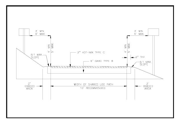
5.1.6.3 Restriction of Motor Vehicle Traffic
Shared use paths need some form of physical barrier at roadway intersections to prevent unauthorized motor vehicles from using the facilities. Provisions can be made for a lockable, removable bollard to permit entrance by authorized vehicles. The bollard should be permanently reflectorized for nighttime visibility and painted a bright color for improved daytime visibility. When more than one bollard is used, five feet of spacing between posts shall be used. Wider spacing can allow entry to motor vehicles, while narrower spacing might prevent entry by adult tricycles and bicycles with trailers.
An alternative method of restricting entry of motor vehicles is to split the entryway into two five-foot wide sections separated by low landscaping. Emergency vehicles can still enter if necessary by straddling the landscaping. The higher maintenance costs associated with landscaping should be considered.
5.1.6.4 Other Design Issues
The preferred pavement surface is a good quality all weather surface. Designing the pavement structure is similar to that of a roadway. Design is based on soil investigation to determine the load-carrying capacity of the existing soils. In this case, the controlling load is that of motorized maintenance and patrol vehicles. The pavement selection is influenced by frost damage potential, skid resistance, surface quality, edge support, and surface and subsurface drainage.
Drainage design for shared use paths is similar to that of a roadway. A cross slope of 2% in one direction with no crown is preferred and also simplifies the construction. Side ditches, ground cover, erosion and all other drainage design elements are a part of the path design.
5.1.7 Traffic Calming. The DelDOT Traffic Calming Design Manual (TCDM) provides detailed guidance regarding the appropriate use, design, signing and marking of traffic calming measures approved for use in Delaware. Generally, traffic calming should be an integral part of a site design so as to reduce the need for speed control devices after subdivision construction.
5.2 Entrance Design Guidelines
The design elements required for a specific entrance shall be constructed within the existing right-of-way or easements of the roadway. As outlined in Section 3.6, the engineer is responsible for verifying the right-of-way width and that the required improvements can be constructed.
If the right-of-way cannot accommodate the required entrance improvements, the developer can either acquire the necessary right-of-way or reduce the traffic generated from the site to eliminate the need for the improvement. Insufficient right-of-way cannot be the basis for sub-standard design.
Entrance design elements include right-turn lanes, left-turn lanes, and bypass lanes, and drainage features. See Figures 5-9 through 5-11 for typical entrances. Entrance design shall be in accordance with the following guidelines:
5.2.1 All entrance-exit facilities shall conform to designs intended exclusively for that purpose. No signs which are contrary to the normal rules of the road (e.g., keep left instead of keep right, etc.) shall be permitted.
5.2.2 If pedestrian amenities exist or are placed as part of the land development, the entrance shall be designed to accommodate pedestrians.
5.2.3 Median islands shall be permitted in the entrance. The median shall have a minimum width of 4 feet and a maximum width of 1216 feet measured from the face of curb. The nose of the median shall be located based on the turning path for the left-turn movement of the design vehicle.
5.24 All entrance-exit facilities shall be located not only to provide compatibility with the highway system and adjacent entrances, but also to provide good internal circulation once the motorist has left the roadway. The site shall be designed so that traffic will not back-up on the State-maintained roadway.
5.2.5 If an entrance is to be controlled by an electronic gating system, the gate shall be located a minimum of 50 feet from the edge of the shoulder.
5.2.6 Where feasible, a major entrance-exit facility on one side of a highway shall be located directly across from a major entrance-exit facility on the opposite side of the highway.
5.2.7 When a parcel of land is being developed which fronts on a major and a minor roadway, the access to this parcel shall be from the minor roadway and not the major roadway. Exceptions may be considered by the Subdivision Engineer.
5.2.8 Roadway width shall be consistent with the type of subdivision street intersecting the roadway. See Figure 5-12.
5.2.9 The radius of the entrance shall be established using the turning path of the design vehicle. A minimum 25-foot radius shall be used on all entrances.
5.2.10 Profiles of entrances and exits shall be designed in accordance with these Standards and Regulations for Subdivision Streets and State Highway Access, and AASHTO’s standards. Maximum grades shall not exceed 8%. Vertical curve transition shall be provided at the intersection of the driveway profile and the cross slope of roadway shoulder extended.
5.2.11 All parking and unparking maneuvers within the immediate area of a commercial entrance shall be avoided. These maneuvers shall not block the entrance and cause the backing-up of traffic onto the highway.
5.2.12 No driveways or parking bays shall be located within 4050 feet from the edge of shoulder or pavement of any type of functional classification roadway.
5.2.13 A motorist's tendency is to follow pavement joint lines instead of the painted lines which denote the actual travel lanes. A conflict between the pavement joints and travel lanes shall be avoided. If this conflict occurs, the pavement shall be covered with a layer of asphalt paving.
5.2.14 The minimum distance between the intersection radius of the entrance with the State-maintained roadway shoulder and the property line of the adjacent property is 5 feet.
5.2.15 Spacing of entrances shall comply with the requirements outlined in Chapter 9.
5.2.16 At signalized intersections, sufficient storage length shall be provided on all left-turn lanes, and on all right-turn lanes that are controlled by separate signal heads (right-turn arrows), to accommodate the 95th percentile queues for those movements and to prevent those lanes from being blocked by the 95th percentile queues in the through lanes. Queue lengths shall be determined through Highway Capacity Software (HCS) analyses of the morning and evening weekday peak hours of the street where the entrance is located. For uses where other peak hours are relevant, e.g. the Saturday midday peak hour for shopping centers, or shift changes for factories, additional analyses may be required.
Figure 5.9 Typical Entrance I
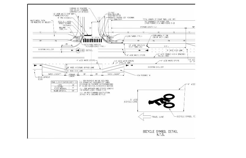
Figure 5.10 Typical Entrance III - Entrance Location for Corner Properties
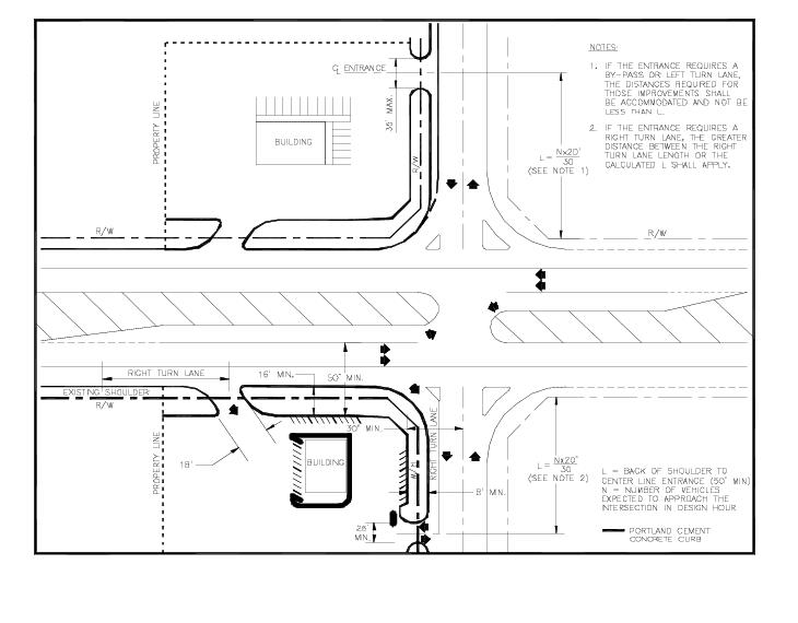
Figure 5.11 Typical Entrance III
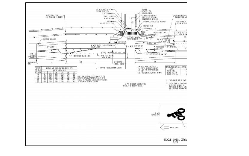
Figure 5.12 Entrance Pavements Widths
Subdivision Street | Pavement Width (With Curb and Gutter) | Pavement Width (Without Curb and Gutter) |
Type I, II, and III (With Median) | 16 feet | 18 feet |
Type I (Without Median) | 22 feet | 22 feet |
Type II and III (Without Median) | 32 feet | 32 feet |
Industrial Streets | 32 feet | 32 feet |
Commercial Access (1-way) | 18 feet | 18 feet |
Commercial Access (2-way) | 24 feet | 30 feet |
Notes: 1. If wider pavements are needed, a plan showing the turning path of the design vehicle must be provided. 2. If multiple lanes of ingress / egress are required to satisfy the capacity needs of the development, the design must be approved by the Subdivision Engineer. | ||
5.3 Bike Accommodation at Entrances
At intersections, bicyclists proceeding straight through and motorists turning right will cross paths. Striping and signing configurations that encourage these crossings in advance of the intersection, in a merging fashion, are preferable to those that force the crossing in the immediate vicinity of the intersection. Site entrance designs must accommodate bicycle traffic.
The design of a bike lane needs to include appropriate pavement markings and signing approaching and through intersections to reduce the number of conflicts. Guidance for signing and pavement marking of bike lanes is shown in the Delaware MUTCD and AASHTO's Guide for the Development of Bicycle Facilities.
A bike lane should be delineated to indicate the separation from the motor vehicle travel lanes with a four-inch wide solid white line. Adequate pavement surface, bicycle-safe grate inlets, and safe railroad crossing shall be provided on roadways where bicycle lanes are being designated. Raised pavement markings and raised barriers can cause steering difficulties for bicyclists and should not be used to delineate bicycle lanes.
5.4 Auxiliary Lanes. Auxiliary lanes provide an area for traffic to maneuver outside of the through lanes to improve safety and capacity of the roadway. Auxiliary lanes include right-turn lanes, left-turn lanes, bypass lanes and crossovers. For unsignalized intersections, the length of auxiliary lanes depends on local conditions, 10-year projected traffic volumes (from the date of submission), traffic mix, design speed, posted speed, selected level of service, and operating speeds.
5.4.1 Right-Turn Lane. Separate right-turn lanes shall be required when warranted in accordance with Figure 5-13 and 5-14. Projected volumes (10-year) shall be used for the analysis. Right-turns can be free flowing, yield or stop-controlled. In order to operate properly, free flowing right-turn lanes must have an adequate deceleration distance with no access points for drivers to safely merge with and diverge from the through traffic.
5.4.2 Left-Turn Lane
Separate left-turn lanes shall be required on two-lane, two-way roadways and divided highways when warranted. When it is determined that a project located on a divided highway shall generate sufficient number of left-turns to warrant the construction of a left-turn lane, it shall be the responsibility of the developer to construct a left-turn lane at the locations designated by DelDOT.
A separate left-turn lane shall be required for all unsignalized subdivision entrances located on undivided highways in accordance with the warrants for left-turns lanes found in Figures 5-15 through 5-18. Projected volumes (10-year) shall be used for Figures 5-13 through 5-18. If the percent distribution of left-turns in the advancing volume during the peak hour is greater than the percentage shown on the intersecting line, a left-turn lane is warranted.
A separate left-turn lane shall be required for all signalized subdivision entrances located on undivided highways in accordance with the most current Highway Capacity Manual guidelines. Projected volumes (10-year) shall be used for the analysis.
When access to a proposed site requires vehicles to utilize an existing left-turn lane, the developer shall perform an operational analysis to determine if there is sufficient storage length. The developer will be required to make any modifications necessary to provide an adequate left-turn lane.
Left-turn lanes may be required when physical characteristics restrict sight distance below AASHTO standards.
Left-turn lanes may be required at age-restricted communities where there is a need to accommodate older drivers.
The pavement design for all left-turn lanes on two-lane, two-way roadways shall be comparable in design to the existing traveled way.
5.4.3 Bypass Lane
A bypass lane is a paved shoulder that permits through traffic to bypass a left-turning vehicle which is stopped on the travel lane. They are intended to reduce delay and expedite the movement of through traffic at T- intersections.
An intersection shall be considered for a separate left turn lane first using the warrants outlined in Figures 5-15 through 5-18. If those warrants are not met then consideration should be given for a by-pass lane. Bypass lanes shall be designed in accordance with Figure 5-20. Projected volumes (10-year) shall be used for the analysis. A five foot shoulder shall be provided on the outside of the bypass lane to accommodate bicycles.
Bypass lanes will not be permitted in the following locations. If a by-pass lane is warranted in these locations then a separate left turn lane shall be constructed in accordance with these standards.
5.4.4 Crossovers
Crossovers are median openings designed to accommodate U-turn vehicles. Crossovers are provided on divided highways at intervals that serve adjacent properties without greatly inconveniencing property owners and other users.
Crossover design at two-lane crossroads or connecting roads shall be in accordance with standard crossover design found in AASHTO’s Policy on Geometric Design of Highways and Streets (The Green Book).
The following general guidelines shall be used:
5.4.4.1 Additional crossovers shall not be placed, regardless of existing spacing on highways, where DelDOT has determined that crossovers should not be added for reasons of safety or capacity.
5.4.4.2 Crossovers shall not be placed on limited access highways under any circumstances.
5.4.4.3 It is desirable to maintain an average spacing of 1000 to 1500 feet at crossovers in urban areas and 2000 to 3000 feet at crossovers in rural areas.
5.4.4.4 Closer spacing shall be permitted when DelDOT finds it beneficial for traffic operations and safety.
5.4.4.5 The absolute minimum spacing of crossovers shall be governed by the requirements for left-turn lanes to include required taper lengths, deceleration lengths and storage lengths.
5.4.4.6 DelDOT may remove crossovers when warranted by changes in surrounding land use or when necessary for traffic operation and safety.
5.4.4.7 Minimum crossover width is 40 feet. The crossover width may be increased as required by the intersecting roadway or entrance condition.
5.4.4.8 The pavement design for all crossovers shall be based on anticipated traffic and soil conditions. Figure 5-19 shows a typical crossover design.
5.5 Bicycle Facilities
Suitable accommodations for bicyclists shall be required for all subdivision and commercial site plans. See Figure 5-21 for typical bike lane cross sections.
Unless access is specifically denied, some level of bicycle use can be anticipated on most roadways. All new roadways, except those where bicyclists shall be legally prohibited, should be designed and constructed to encourage use of bicycles as a form of transportation. Guidelines are presented here to help design and construct roadway improvements and separate facilities that accommodate the operating characteristics of bicycles. Additional information including signing layouts, striping, and design details can be found in the Delaware MUTCD and AASHTO's Guide for the Development of Bicycle Facilities.
Figure 5.13 Right-Turn Lane Warrants (R < 50’ )
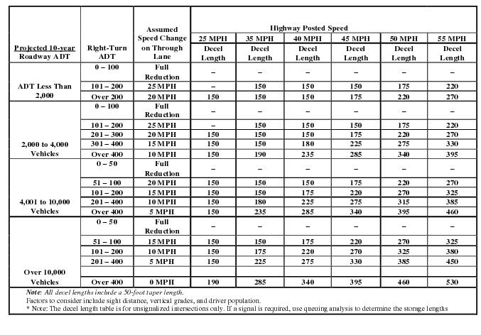
Figure 5.14 Right-Turn Lane Warrants (R > 50’ )

Figure 5.15 Left-Turn Lane Warrants at Unsignalized Intersections – 25 MPH
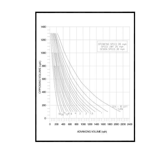
Figure 5.16 Left-Turn Lane Warrants at Unsignalized Intersections – 35 MPH
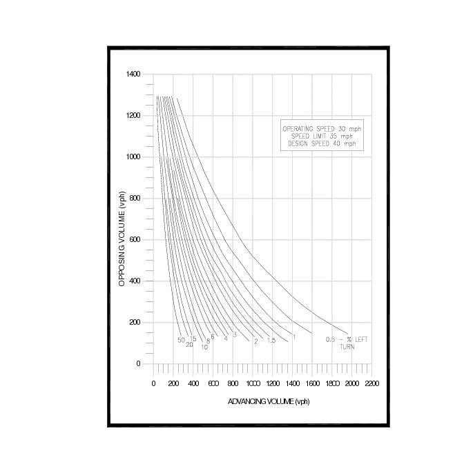
Figure 5.17 Left-Turn Lane Warrants at Unsignalized Intersections – 45 MPH
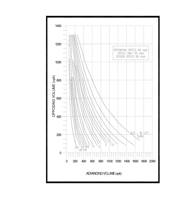
Figure 5.18 Left-Turn Lane Warrants at Unsignalized Intersections – 55 MPH
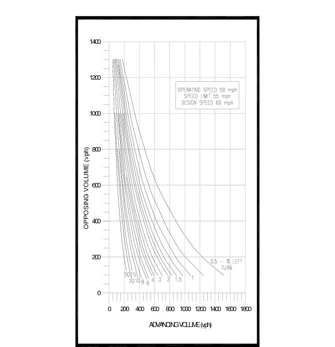
Figure 5.19 Typical Turning Lane Design for Divided Highways
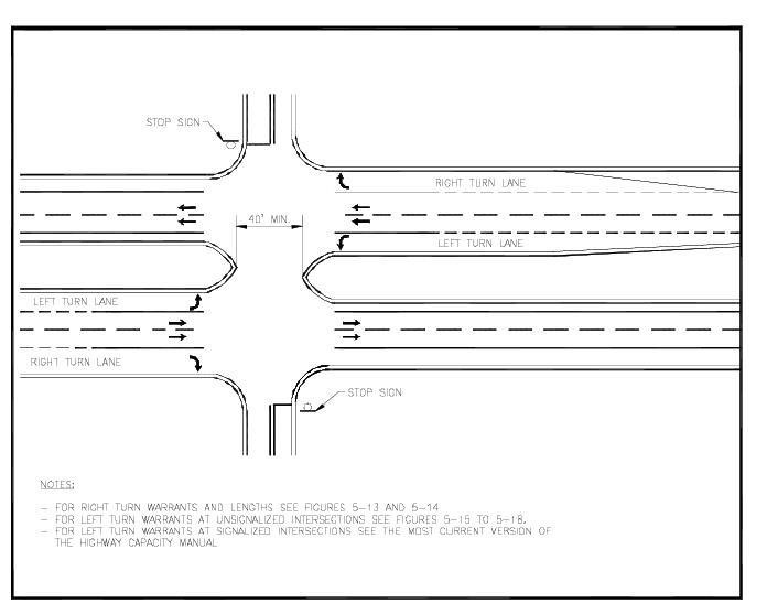
Figure 5.20 Length of Bypass Lanes for Two Lane Highway
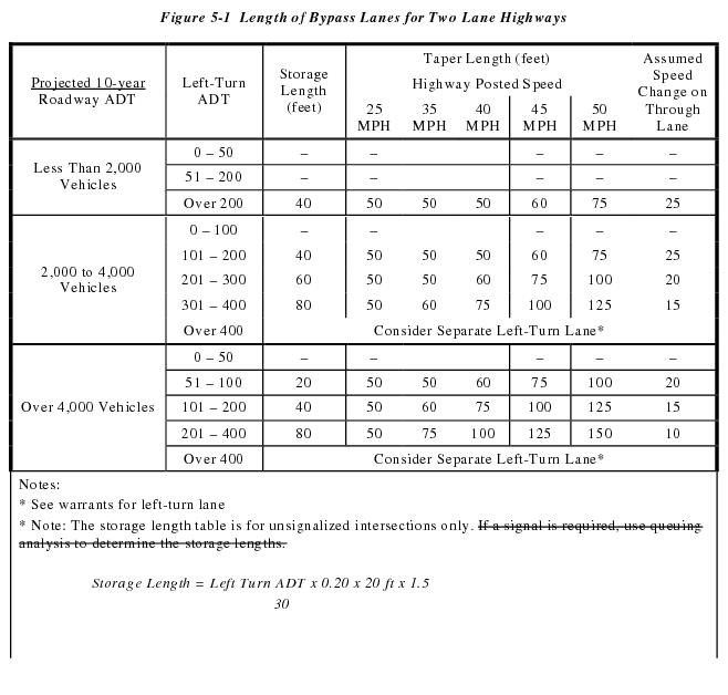

Figure 5.21 Typical Bike Lane Cross Sections
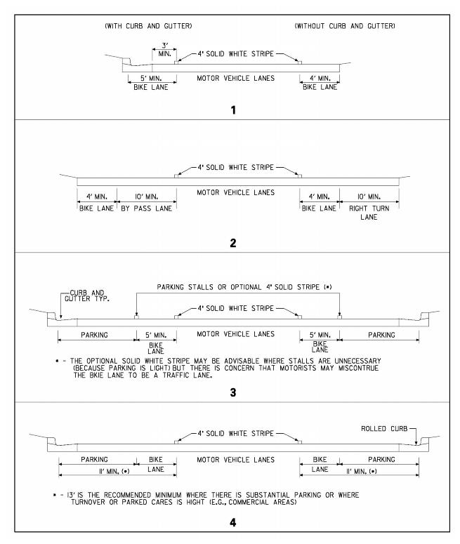
5.6 Sight Distance. When an entrance is provided to a State-maintained roadway, the area adjacent to right-of-way shall be clear and free of obstructions. When approaching an intersection, a driver should have an unobstructed view of the intersecting roadway and the ability to view any approaching vehicles at the intersection.
5.6.1 The entrance location and design shall provide a clear line-of-sight for the driver of a vehicle preparing to enter the roadway in accordance with AASHTO location and design standards.
5.6.2 The departure sight triangle (see Figure 5-22) shall be used at entrances where a stopped driver on a minor road approach (entrance) attempts to depart from the intersection and enter or cross a major road. Calculated distance from center of travel lane to 10 feet behind stop bar ((a) in Figure 5-22)) shall be used as the decision point in departure sight triangle.
5.6.3 Any marquee sign located in conformance with the “Outdoor Advertising” requirements must be placed to maintain the required sight distance.
5.6.4 If the sight triangle established in accordance with the AASHTO standards is outside the existing right-of-way an easement shall be established to maintain the required sight distance. See Figure 5-22.
5.6.5 At subdivision entrances, the sight triangle shall be maintained and be free of plantings that could obstruct the sight distance.
5.6.6 Within the streets of a subdivision the placement of shrubbery or other visual barriers is prohibited within the triangular area formed by the intersection of two curb lines and a line joining the respective points on each of these lines at a distance of 30 feet from the point of intersection. These triangular areas shall be designated on the site plans as sight triangle easements. DelDOT shall have full authority to maintain the required sight distance. Fire hydrants shall not be considered visual barriers or hazardous obstacles.
Figure 5.22 Sight DistanceTriangles
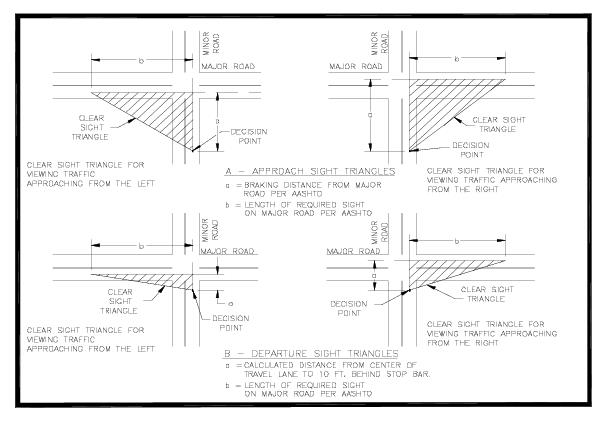
5.7 Typical Sections
5.7.1 Subdivision Streets – Typical sections for subdivision streets define the roadway width and cross slopes, stormwater runoff accommodations (curbs or ditches/ sideslopes), and clear zones.
5.7.2 State-maintained Roadways – If an entrance requires any modification or improvement on the State-maintained roadway, a typical section shall be required. The typical section shall show the proposed pavement widths and sideslopes as outlined in this section.
5.7.3 Pavement Widths
5.7.3.1 Subdivision Streets – Pavement widths vary for each subdivision street. See Figures 5-23 through 5-25 for typical sections.
5.7.3.2 State-maintained Roadways – The width of auxiliary lanes associated with the entrance design shall be a minimum of ten feet in width. If accommodations are being made for bikes on the facility, the width of the auxiliary lane shall be increased to a minimum width of 15 feet. The lateral offset of an auxiliary lane shall accommodate a minimum 11-foot wide through lane.
5.7.4 Curbs
Curbing may be used on subdivision streets to accommodate stormwater runoff. When the design velocity of an open ditch section exceeds 4 ft./sec., a curb and gutter system shall be used. Refer to the DelDOT Standard Construction Details for acceptable curb types.
A minimum of six inches of GABC type B shall be placed under all curbs and shall extend six inches beyond the back of curb.
Curbs shall be used for all entrances and islands located in the following areas:
The type of curb to be used must be shown on the entrance drawing. Where the existing roadway is not curbed, the islands and curbs shall be placed no closer than ten feet from the edge of the roadway. Where the roadway is curbed, any curb returns of the driveway shall match the existing curb line.
No portable curb channelization shall be permitted on the entrance facility. Curbing for channelization should be constructed using a mountable-type curbing. Curbing can either be cast in place using forms or can be slip formed. Curbing placed on existing pavement shall be secured to the pavement surface by use of dowels, form pins, rebars, or other suitable means and must be approved by DelDOT. Special details must be included in the construction plans. Channelization may be poured monolithically.
In rural areas curbing may be omitted if access and drainage can be effectively controlled by an existing roadside ditch or other means as determined by DelDOT.
Curbs being used on roadways with a posted speed limit of 50 mph or greater shall be limited to a 4 inch vertical face.
5.7.5 Ditches and Sideslopes
5.7.5.1 Subdivision Streets – The ditch and sideslope sections for subdivision streets shall meet the minimum slopes as shown on Figures 5-23 through 5-25.
The minimum depth of a ditch has been established to provide for sub-surface drainage. This minimum depth must be maintained throughout the subdivision. This depth can vary if a swale over a closed drainage system is used.
To minimize rutting and erosion of the roadside due to on-street parking, the site plan shall be developed to allow for three vehicles to be stored in the driveway beyond the right-of-way. A note on the record plan shall state this requirement.
On streets without curbs, a six-foot grass shoulder shall be treated with an approved turf reinforcement mat to protect the edge of the pavement and to minimize the potential for soil erosion. In addition, design stormwater velocities within the open ditch section shall be limited to a maximum of five feet per second.
5.7.5.2 State-Maintained Roadways – DelDOT’s Road Design Manual and AASHTO’s Roadside Design Guide shall be used when designing sideslopes and ditch sections associated with any entrance improvements.
If pipes are used at site entrances in conjunction with an open drainage system, the longitudinal slope from the entrance pavement to the top of the pipe shall be six-to-one (6:1).
5.7.6 Underdrains
The long-term presence of water within the pavement structure is largely responsible, directly and indirectly, for many of the distress and performance problems in pavement systems. The addition of longitudinal perforated underdrains is a feasible and cost-effective option. Underdrains are a system of perforated pipes that collect and transmit the water to an outfall site.
Underdrains shall be installed on all subdivision streets. The typical section shall show the location of the underdrain in accordance with Figures 5-23 through 5-25. Refer to DelDOT’s Standard Construction Details for dimensions and materials.
If the developer can, through an engineering analysis, signed and sealed by a Professional Engineer registered in Delaware, prove underdrains are not warranted, DelDOT shall grant a waiver on the required underdrains referenced above. All costs associated with the developer’s engineering analysis shall be at their cost. DelDOT will not provide any reimbursement.
The engineering analysis shall include the following:
5.7.6.1 Average water table for the last 25 years for the area in question.
5.7.6.2 Soil boring information including characteristics and AASHTO classification.
5.7.6.3 Infiltration rate (tested in accordance with ASTM D5126-90 “Comparison of Field Methods for Determining Hydraulic Conductivity in the Vadose Zone”).
5.7.6.4 Topography maps for the area in question,
5.7.6.5 USGS wetland delineation maps.
Upon submission of all the information listed above, DelDOT will review the analysis and provide a written response to the developer’s request for non-utilization of underdrains.
5.7.7 Clear Zone
The clear zone is defined in AASHTO’s Roadside Design Guide as “the total roadside border area, starting at the edge of the traveled way, available for safe use by errant vehicles. This area may consist of a shoulder, a recoverable slope, a non-recoverable slope, and/or a clear run-out area. The desired width is dependent upon the traffic volumes and speeds and on the roadside geometry.”
Adequate lateral clearance between the edges of traffic lanes and roadside obstructions has been shown to be a very important safety factor. Vehicles leaving the roadway should have a reasonable opportunity to recover control and return to the roadway without overturning or colliding with roadside obstacles such as trees, poles, headwalls, or other large objects. The combination of a relatively flat slope and an obstacle-free roadside within the prescribed clear zone helps this situation.
The determination of a clear zone is a function of speed, volume, curvature, and embankment slope. The current edition of AASHTO’s Roadside Design Guide should be used for determining clear zone widths. For entrances onto rural collectors and rural local roads, a minimum clear zone width of ten feet from the edge of travel lane shall be provided. For subdivision streets, a minimum clear zone of three feet measured from the back of curb shall be provided.
Some roadside appurtenances, such as guardrails, breakaway light poles and signs using breakaway posts, may be part of a proposed development. If they are located within the specified clear zone they must be crashworthy in accordance with NCHRP Report 350 Test Level III Criteria. They should also be placed in the safest available location, minimizing their use when possible.
For guardrails within the clear zone, it is desirable to maintain a minimum two-foot lateral clearance between the outer edge of the usable shoulder and the face of the rail. Guardrails in and of themselves present a hazard and only should be used as a last resort if objects can not be moved or the required sideslopes can not be provided. At bridge approaches, guardrails should either match the width of the bridge or taper to meet the bridge rail. Refer to DelDOT’s Standard Construction Details for more information on guardrail types and end treatments.
Figure 5.23 Subdivision Street Typical Section (With Curb)
(Not to Scale)
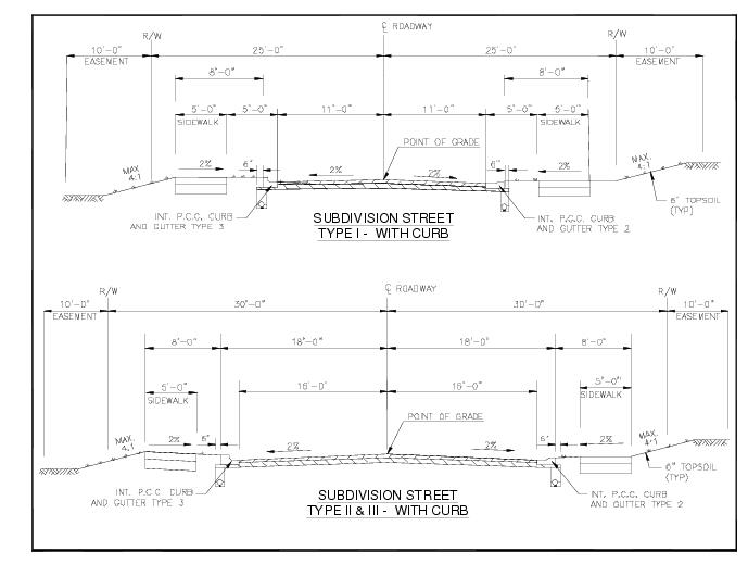
Figure 5.24 Subdivision Street Typical Section (Without Curb)
(Not to Scale)
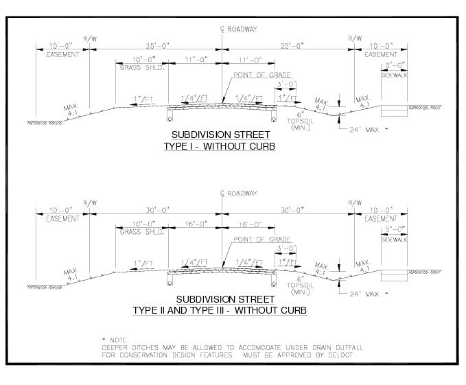
Figure 5.25 Industrial Streets Typical Section (With and Without Curb)
(Not to Scale)
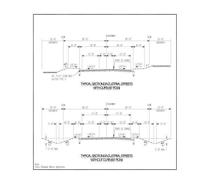
5.8 Pavement Sections. Pavement sections are to be designed based on the ADT utilizing the planned roadway and the existing subsurface conditions. Acceptable pavement sections have been provided in Figure 5-22 and 5-23. If there is a concern with existing soil conditions DelDOT may perform subsurface investigations, at no cost to the developer, to determine subsurface conditions and if undercutting may be required prior to pavement box construction. This request shall be made prior to preliminary plan submission. The pavement sections listed in Figure 5-27 and 5-28 are designed to meet the required Structural Numbers (SN) and meet the following four conditions/criteria:
Materials placed for construction of roadways in subdivisions, entrances, and industrial roadways must not be constructed in lifts that violate DelDOT’s minimum and maximum lift thickness. The allowable lift thickness and structural values for materials used are shown in Figure 5-26.
Figure 5.26 Material Properties
Lift Thickness | SN Contribution New (old) | ||
Minimum | Maximum | ||
Hot-Mix Asphalt Type C | 1 ¼” | 2” | 0.4 (0.35) |
Hot-Mix Asphalt Type B | 2 ¼” | 3” | 0.4 (0.35) |
Bituminous Concrete Base Course (BCBC) | 3” | 6” | 0.32 (0.29) |
GABC | – | 8” | 0.14 (0.14) |
5.8.1 Subdivision Streets
All subdivision streets and entrances shall be paved with a hot-mix asphalt or Portland cement concrete surface. Pavement sections for internal subdivision streets are to be built to serve the traffic generated from the development upon completion, including all construction related traffic of the development. Should additional phases be planned that will be connected to the portion of the development under construction, the pavement section for the street shall be such that it will support both the phase under construction and the future phases. Figure 5-27 shows examples of pavement sections acceptable for use on internal subdivision streets.
When calculating the structural number of a section, consider whether traffic has been on the layer. For example:
A subdivision has an ADT of 136. Figure 5-27 requires that the structural number at completion be 2.27, while the section in place prior to 80% completion of the development must have a structural value of 1.65. To determine the structural value of the overall section, it is assumed that the materials in place (B and GABC) prior to completion have lost some of their structural value. Therefore, the calculation to determine the structural capacity of the section uses a combination of the new and old SN contribution values and is:


The structural number meets the requirements structurally for the overall value and meets the four conditions set forth in the beginning of this section. Once it is established that these are sufficient, the section must be verified to meet the required structural value. This calculation uses all new SN contribution values and is as follows:


This calculation shows how the required section is calculated and may be used to adjust thickness requirements of example sections as long as all requirements are met and lift thickness values are not violated.
Figure 5.27 Pavement Design Chart for Internal Subdivision Streets
ADT | Required Structural Number – Overall (prior to 80% completion) | Pavement Section |
1 – 150 | 2.27 (1.65) | 1 ¼” Type C 2 ¼” Type B 8” GABC |
151 – 500 | 2.78 (2.05) | 1 ½ ” Type C 3” Type B 8” GABC |
501 – 1000 | 3.12 (2.32) | 2” Type C 3” Type B 10” GABC (two equal lifts) |
1001 – 2000 | 3.49 (2.63) | 2” Type C 3” Type B 12” GABC (two equal lifts) |
2001 – 3000 | 3.73 (2.84) | 2” Type C 3” Type B 14” GABC (two equal lifts) |
3001 – 5000 | 4.05 (3.13) | 1 ¼” Type C 2 ¼” Type B 6” BCBC 8” GABC |
> 5000 | Submit data to DelDOT for Pavement design | |
5.8.2 Entrances. Pavement sections for entrances on State-maintained roadways are to be designed using the average daily traffic using that entrance or 20% of the mainline traffic, whichever is greater (see Figure 5-28). Other sections to be constructed in conjunction with the entrance to the highway that must be submitted for design by DelDOT are:
Figure 5.28 Pavement Design Chart for Entrances
CLASS | Required Structural Number | Pavement Section |
Class A • Traffic Volume less than 50 ADT • No Trucks | 2.40 | 1 ¼” Type C 2 ¼” Type B 8” GABC |
Class B • Traffic Volume 51 to 500 ADT • No trucks | 2.78 | 1 ¼” Type C 3” Type B 8” GABC |
Class C • Traffic Volume 501 to 2000 ADT • Less than 15 light duty trucks per day | 3.49 | 2” Type C 3” Type B 11” GABC (two equal lifts) |
Class D • Traffic Volume 2001 to 5000 ADT • Less than 50 light duty trucks per day | 4.05 | 1 ¼” Type C 2 ¼” Type B 5” BCBC 8” GABC |
Class E • Traffic volume > 5000 ADT • Over 50 trucks per day | Submit data to DelDOT for Pavement design | |
5.8.3 Industrial Streets / Entrances. Streets that are to be used as entrances to industrial parks must be built to State requirements. DelDOT must perform all pavement designs for proposed industrial streets, because no industrial street is anticipated to carry similar loadings.
5.9 Drainage Design
5.9.1 General
Surface runoff water is a serious threat to both the physical integrity and the serviceability of roadway facilities. Runoff water must be adequately controlled so that it may pass through and be removed from the roadway area without damaging the roadway or adjacent properties.
As part of the overall design, the developer’s engineer shall provide adequate drainage of the roadway and the site in accordance with all applicable standards. DelDOT has jurisdiction over drainage and any drainage system that impacts the State right-of-way.
A drainage report shall be submitted with the construction plans to verify pipe sizing, Hydraulic Grade Line (HGL), pipe cover, velocities, stabilization and water spread on the roadway.
5.9.2 Drainage Criteria. Drainage criteria for different drainage installations are discussed below and summarized in Figure 5-30.
5.9.2.1 Culverts
A culvert is a drainage structure which transports water from a natural drainage course.
Based on the peak flow and watershed area, an appropriate tool for determining runoff shall be determined. The following criteria shall be used for culverts:
See Hydraulic Design Series Number 5 (HDS 5), Hydraulic Design of Highway Culverts, September 2001, USDOT, FHWA.
5.9.2.2 Storm Sewers. The following criteria shall be used for storm sewers:
OR
If the Natural Resources Conservation Service (NRCS) method is used in calculating the HGL, the engineer shall specify in the report or on the plans which criterion was used to determine the HGL elevations.
See Design of Urban Highway Drainage - The State of the Art, August 1979, USDOT, FHWA for additional information on storm sewer design.
Culverts and storm sewers can be made from Reinforced Concrete Pipe (RCP), Metal Pipe (MP) or High Density Polyethylene (HDPE). The use of these material types is outlined in Figure 5-29. Refer to DGM 1-20 Pipe Materials for further information.
5.9.2.3 Inlet Design. Inlet design for entrances shall be in accordance with DelDOT’s Road Design Manual. The following criteria shall be used for inlets within subdivision streets:
5.9.2.4 Parallel Ditching. The following criteria shall be used for parallel ditching:
Figure 5.29 Material Usage for Culverts and Storm Sewers
RCP | HDPE | MP | |||
Class III | Class IV | Class V*** | |||
Embankment Height* | > (1) foot | 6 inches to 1 foot | < 6 inches | 1 foot on local roads. 2 feet on collectors & arterials.** | 1 foot on local roads. 2 feet on collectors & arterials.** |
* From top of pipe to the bottom of flexible pavement. ** The use of MP and HDPE must be approved by DelDOT. *** The use of Class V pipe must be approved by DelDOT. | |||||
5.9.2.5 Drainage Easements. Drainage easements are required for all drainage facilities handling subdivision street runoff which are not located within a dedicated right-of-way. Underground drainage facilities shall require a 20-foot drainage easement. The pipe must be located in the center of the easement. Open drainage facilities shall require a width equal to the width of the facility at the proposed ground level plus a 10-foot easement on one side and a minimum of a five-foot easement on the other side of the open drainage facility.
5.9.2.6 Offsite Easements. Drainage easements are required for offsite drainage facilities in order to provide positive drainage from the development to the point of discharge. Development drainage must be carried to a natural or existing drainage course. Copies of drainage easements are to be provided to DelDOT and referenced on the record plan.
5.9.2.7 Drainage Discharge. The outfall shall be carried to a point of positive outfall in order to prevent downstream flooding. A detailed hydraulic and stormwater analysis downstream any distance as deemed necessary shall be required to determine the impacts to the drainage system and to ensure that stormwater impacts for surrounding property owners is minimized.
5.9.2.8 Drainage Design Report. A drainage design report containing the following minimum data shall be prepared for each project.
5.9.2.8.1 Drainage area plan.
5.9.2.8.2 Time of concentration.
5.9.2.8.3 Weighted runoff coefficient.
5.9.2.8.4 Design discharge.
5.9.2.8.5 Type and slope of drainage facility.
5.9.2.8.6 Spacing of drainage inlets.
5.9.2.8.7 Erosion protection methods – riprap sizing calculations.
5.9.2.8.8 Inlet spread calculations.
5.9.2.8.9 Culverts – headwater elevations.
5.9.2.8.10 Hydraulic Grade Line (HGL) calculations.
5.9.2.8.11 Full flow pipe velocity.
5.9.2.8.12 Actual flow pipe velocity.
5.9.2.8.13 Difference between inlet grate elevation and HGL elevation.
See Figures 5-37 through 5-42 for various drainage charts that are to be used in the preparation of the drainage report.
Figure 5.30 Drainage Criteria
Type | Design Frequency | Minimum Flow Full Velocity (ft/sec) | Maximum Allowable Velocity (ft/sec) | Free Board from Edge of Roadway | |
Normal | Sag | ||||
Culvert | 25 | 25 | 2 | – | 1 foot |
Storm Sewer | 10 | 25 | 2 | 8 | 1 foot |
Roadside Ditch | 10 | 10 | – | 3 | 6 inches |
Inlets | 10 | 10 | 2 | 8 | – |
Figure 5.31 Angle of Deflection for Circular Reinforced Concrete Pipes Entering and Exiting Inlet Boxes
Figure 5.32 Angle of Deflection of Horizontal Elliptical Contrete Pipes Entering and Exiting Inlet Boxes
Figure 5.33 Angle of Deflection of Arched Concrete Pipes Entering and Exiting Inlet Boxes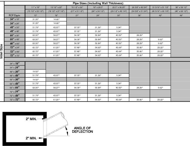
5.9.3 Personnel Grate for Pipe Inlet. Personnel grates shall be installed on pipe inlets to improve safety by preventing people, animals and debris from entering stormwater pipes 12 inches and larger with open inlets (i.e., without a grate or drainage inlet) for which full daylight is not visible when looking through the pipe to the other end.
5.9.3.1 Design Guidance
Since safety grates become blocked by debris, thus potentially decreasing drainage flow and increasing maintenance needs, engineers shall evaluate designs to avoid open inlets to stormwater pipes. One alternative to consider is creating a separation of pipe runs by realigning pipes in a long pipe run into relatively short, straight runs, with daylight visible from the openings.
A personnel grate for a pipe inlet shall be considered as the last resort in designing inlets for storm drain systems. Grates shall be secured to prevent entry by the public but allow access to the storm drainpipe for maintenance and repair.
Construction details and specifications shall be included in the construction plans.
5.9.4 Hydrology. The Rational Method of estimating the storm runoff shall be utilized for all subdivision streets and waterway openings equal to or less than 19 square feet. The proposed method for computing the storm runoff requiring a waterway opening greater than 19 square feet shall be approved by DelDOT. The Rational Method of design is as follows:
Q = C i A
Where,
Q = Rate of runoff in cubic feet per second.
C = Weighted runoff coefficient (average of the coefficients assigned to the different types of contributing areas).
i = Average rainfall intensity, inches per hour, for the selected frequency and for duration equal to the time of concentration.
A = drainage area, in acres, tributary to the point under design.
Values of runoff coefficient (C) for various types of contributing areas indicated in Figure 5-34 shall be utilized in the solution of this method of design.
Figure 5.34 Runoff Coefficient (C) for Use in Rational Methods
Type of surface | Runoff coefficient (C) |
Rural areas | 0.15-0.3 |
Concrete or sheet asphalt pavement | 0.8-0.9 |
Asphalt macadam pavement | 0.6-0.8 |
Gravel roadways or shoulders | 0.4-0.6 |
Bare earth | 0.2-0.9 |
Steep grassed areas (2:1) | 0.5-0.7 |
Turf meadows | 0.1-0.4 |
Forested areas | 0.1-0.3 |
Cultivated fields | 0.2-0.4 |
For flat slopes or permeable soil, use the lower values. For steep slopes or impermeable soil, use the higher values.
Contributing drainage areas shall be evaluated based on the fully developed land in accordance with the existing or proposed zoning.
Figure 5.35 Runoff Coefficient (C) for Difference Type of surfaces
Type of surface | Runoff coefficient (C) |
Flat residential, with about 30% of area impervious | 0.40 |
Flat residential, with about 60% of area impervious | 0.55 |
Moderately steep residential, with about 50% of area impervious | 0.65 |
Moderately steep built up area, with about 70% of area impervious | 0.80 |
Flat commercial, with about 90% of area impervious | 0.80 |
For a more detailed explanation of the Rational Method of design see “Design of Roadside Drainage Channels,” published by USDOT, FHWA.
5.9.5 Hydraulics. Manning’s Equation shall be utilized to express the flow of water in open channels. Manning’s Equation is as follows:
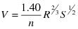
Where:
V = Velocity in feet per second
n = Manning’s coefficient of channel roughness
R = Hydraulic radius, in feet
S = Slope, in feet per foot
Values of Manning’s coefficients (n) for various types of channel linings as indicated in Figure 5-36 shall be used.
For additional values see “Design Charts for Open-Channel Flow,” published by USDOT, FHWA.
Figure 5.36 Mannings Roughness Coefficients (n)
Closed Conduits | |
Reinforced Concrete Pipe (RCP) | 0.012 |
Corrugated Metal Pipe (CMP) or Pipe Arch Plain or Fully Coated (Unpaved) | 0.024 |
High Density Polyethylene (HDPE) | 0.011 |
25% of circumference paved | 0.021 |
Fully paved | 0.012 |
Lined Open Channels | |
Concrete (float finish) | 0.014 |
Plain riprap | 0.040 |
Grouted riprap | 0.035 |
Swales and Channels with Maintained Vegetation | |
Grass (mowed to 2”) | 0.045 |
Grass (good stand - 12” height) | 0.09 |
Street Gutters | |
Concrete | 0.012 |
Asphalt | 0.013 |
5.9.6 Sump Pump Discharges
Sump pump discharges into roadside drainage systems shall be approved in writing by the DelDOT subdivisions inspector prior to installation. Prior to request for approval to discharge sump pump effluent into a roadside drainage system, the developer must provide written justification that there is no other feasible alternative. The developer must prove that the discharge cannot be routed to another outlet that is not within State right-of-way, and the drainage cannot be contained within the parcel boundaries of the discharge source. This justification shall be approved (in writing) by the Conservation District.
If there is no alternative drainage outlet for the sump pump discharge other than the roadside drainage system (State right-of-way), then DelDOT may allow a connection within State right-of-way.
If there is an existing ditch in front of the property, then the sump pump outlet pipe may discharge into the ditch.
If there is an existing drainage inlet and closed drainage system in front of the property, then the Developer may connect the sump pump outlet discharge pipe directly into the drainage inlet. The hole in the basin must be core drilled (not jack-hammered). After installing the discharge pipe, the hole must be sealed with non-shrink grout to prevent leakage. The connection must be at least 12 inches from any pipe joints.
If there is a closed drainage system in front of the property, but no drainage inlet or ditch line exists, then a direct connection of the sump pump discharge pipe to the existing roadside drainage pipe within State right-of-way will be permitted. The tie-in must be made in the upper half of the pipe. The hole in the pipe must be core drilled (not jack hammered). After connecting the discharge pipe, the hole must be sealed with non-shrink grout to prevent leakage. The connection must be at least 12 inches from any pipe joints.
If there is an existing curb and gutter with no enclosed drainage or ditch in front of the property, then sump pump discharge into State right-of-way may be permitted. However, the sump pump discharge outlet pipe must be terminated at the State right-of-way line.
5.10 Erosion Control
DelDOT will work cooperatively with regulating agencies to ensure proper erosion control. These agencies include Delaware Department of Natural Resources and Environmental Control (DNREC), New Castle County Land Use Engineering, New Castle County Conservation District, Kent Conservation District (KCD), and Sussex Conservation District (SCD).
All developments shall require a written plan for erosion control measures both during and after construction following the requirements outlined in Delaware’s Sediment and Stormwater Regulations. The erosion control measures shall be designed following the Delaware Erosion and Sediment Control Handbook (Delaware ESC Handbook) including, but not be limited to, inlet protection, silt fence, stabilized rock construction entrance, sediment traps, stone check dams, temporary and permanent seeding, and mulching as required to minimize erosion during earth moving operations.
In addition to the Delaware ESC Handbook, the Conservation Design For Stormwater Management Guidelines shall be used whenever possible in conjunction with the Erosion and Sediment Control Best Management Practices (BMPS) for all projects.
When the proposed roadway work is limited to the site and the entrance, the review of design and construction of stormwater management and erosion control facilities is performed by a non-DelDOT delegated agency for DSSR enforcement. In this case, the non-DelDOT delegated agency shall attest that the DSSR within DelDOT right-of-way have been met and shall be documented in a memo and forwarded to DelDOT’s Stormwater Engineer for files.
If the proposed roadway work is not contiguous with the land development proposal, the review of design and construction of erosion control plans shall be performed by DelDOT for DSSR enforcement. DelDOT will sign the plans upon determination of full compliance of the plans and reports with the requirements of DSSR indicating that the plans meet the requirements of State and Federal sediment and stormwater regulations. DelDOT shall require at least 30 calendar days to review the erosion control plans.
Plans for review shall be developed in half size (11”x17”) and arranged similar to DelDOT plans for consistency and ease of review. Section 1 of ES2M Design Guide contains a checklist which shall be completed and submitted with the plans along with a transmittal memo requesting the plans to be reviewed by DelDOT.
5.10.1 Riprap Design
Ripraps are a section of rock protection placed at the outlet end of culverts, conduits and channels, to reduce the velocity and energy of water such that the flow will not erode the receiving downstream areas.
The design of rock outlet protection depends entirely on location. Pipe outlets at the top of cuts or on slopes steeper than 10%, can not be protected by rock aprons or riprap section due to reconcentration of flows and high velocities encountered after the flow leaves the apron.
For detailed design guidelines see the latest edition of DNREC’s Erosion and Sediment Control Handbook.
5.11 Structure Design
Any structure, including supports, erected over a depression or an obstruction, such as water, a highway or a railway, for carrying vehicular or pedestrian traffic or other moving loads that has an opening exceeding 20 square feet shall be reviewed by DelDOT’s Bridge Design Section.
All structural designs shall be in accordance with DelDOT’s Bridge Design Manual and AASHTO’s Load and Resistance Factor Design (LRFD) Bridge Design Specifications.
If there are structural designs required on a plan and not included in the Standard Construction Details, shop drawings signed and sealed by a professional engineer registered in the State of Delaware shall be submitted for review and approval.
Figure 5.37 Rainfall Intensity Estimates and Depths - New Castle County, Delaware
Rainfall Intensity Estimates (in/hr) New Castle County, Delaware | ||||||||||
Frequency (yr) | Duration (min) | |||||||||
5 | 10 | 15 | 30 | 60 (1 hr) | 120 (2 hr) | 180 (3 hr) | 360 (6 hr) | 720 (12 hr) | 1440 (24 hr) | |
2 | 4.97 | 3.97 | 3.33 | 2.30 | 1.44 | 0.87 | 0.62 | 0.38 | 0.23 | 0.13 |
5 | 5.83 | 4.67 | 3.94 | 2.80 | 1.79 | 1.08 | 0.78 | 0.48 | 0.29 | 0.17 |
10 | 6.42 | 5.13 | 4.33 | 3.13 | 2.04 | 1.24 | 0.89 | 0.55 | 0.34 | 0.20 |
25 | 7.13 | 5.68 | 4.80 | 3.55 | 2.37 | 1.45 | 1.05 | 0.66 | 0.41 | 0.25 |
50 | 7.60 | 6.05 | 5.10 | 3.84 | 2.60 | 1.61 | 1.18 | 0.74 | 0.47 | 0.29 |
100 | 8.06 | 6.40 | 5.40 | 4.13 | 2.85 | 1.77 | 1.30 | 0.83 | 0.53 | 0.34 |
200 | 8.44 | 6.69 | 5.63 | 4.38 | 3.07 | 1.93 | 1.43 | 0.92 | 0.60 | 0.39 |
500 | 8.88 | 7.02 | 5.89 | 4.69 | 3.36 | 2.14 | 1.60 | 1.05 | 0.70 | 0.46 |
Interpolation shall be used for intermediate durations. | ||||||||||
Figure 5.38 Rainfall Intensity Estimates and Depths – Kent County, Delaware
Rainfall Intensity Estimates (in/hr) Kent County, Delaware | ||||||||||
Frequency (yr) | Duration (min) | |||||||||
5 | 10 | 15 | 30 | 60 (1 hr) | 120 (2 hr) | 180 (3 hr) | 360 (6 hr) | 720 (12 hr) | 1440 (24 hr) | |
2 | 5.06 | 4.05 | 3.40 | 2.34 | 1.47 | 0.90 | 0.65 | 0.40 | 0.24 | 0.14 |
5 | 6.01 | 4.81 | 4.06 | 2.88 | 1.85 | 1.13 | 0.82 | 0.50 | 0.30 | 0.18 |
10 | 6.68 | 5.35 | 4.51 | 3.27 | 2.13 | 1.31 | 0.95 | 0.59 | 0.36 | 0.21 |
25 | 7.54 | 6.01 | 5.08 | 3.76 | 2.50 | 1.56 | 1.14 | 0.71 | 0.44 | 0.27 |
50 | 8.15 | 6.49 | 5.48 | 4.13 | 2.79 | 1.76 | 1.29 | 0.81 | 0.51 | 0.32 |
100 | 8.76 | 6.96 | 5.86 | 4.49 | 3.09 | 1.96 | 1.45 | 0.92 | 0.59 | 0.37 |
200 | 9.32 | 7.39 | 6.22 | 4.84 | 3.39 | 2.17 | 1.62 | 1.04 | 0.67 | 0.43 |
500 | 10.02 | 7.93 | 6.65 | 5.29 | 3.80 | 2.45 | 1.85 | 1.21 | 0.80 | 0.52 |
Interpolation shall be used for intermediate durations. | ||||||||||
Figure 5.39 Rainfall Intensity Estimates and Depths – Sussex County, Delaware
Rainfall Intensity Estimates (in/hr) Sussex County, Delaware | ||||||||||
Frequency (yr) | Duration (min) | |||||||||
5 | 10 | 15 | 30 | 60 (1 hr) | 120 (2 hr) | 180 (3 hr) | 360 (6 hr) | 720 (12 hr) | 1440 (24 hr) | |
2 | 5.06 | 4.04 | 3.39 | 2.34 | 1.47 | 0.91 | 0.66 | 0.40 | 0.24 | 0.14 |
5 | 6.02 | 4.83 | 4.07 | 2.89 | 1.85 | 1.16 | 0.84 | 0.52 | 0.30 | 0.19 |
10 | 6.76 | 5.40 | 4.56 | 3.30 | 2.15 | 1.35 | 0.99 | 0.61 | 0.36 | 0.22 |
25 | 7.67 | 6.11 | 5.16 | 3.82 | 2.54 | 1.61 | 1.19 | 0.74 | 0.45 | 0.28 |
50 | 8.32 | 6.62 | 5.59 | 4.21 | 2.85 | 1.83 | 1.35 | 0.85 | 0.52 | 0.33 |
100 | 8.96 | 7.12 | 6.00 | 4.59 | 3.16 | 2.05 | 1.53 | 0.97 | 0.61 | 0.38 |
200 | 9.60 | 7.61 | 6.40 | 4.98 | 3.49 | 2.28 | 1.71 | 1.10 | 0.70 | 0.45 |
500 | 10.38 | 8.21 | 6.88 | 5.48 | 3.93 | 2.59 | 1.97 | 1.28 | 0.84 | 0.54 |
Interpolation shall be used for intermediate durations. | ||||||||||
Figure 5.40 Overland Flow Time
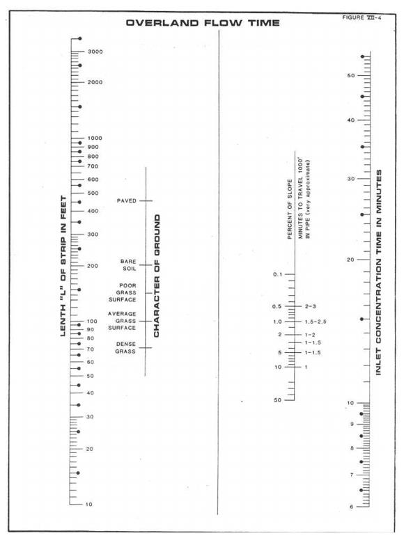
Figure 5.41 Street Flow Time
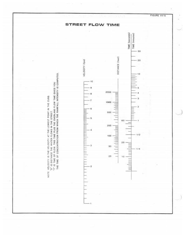
Figure 5.42 Flow in Triangular Channels
5.12 Signing and Pavement Marking Design
5.12.1 Signing
Traffic control signs shall be required for all commercial and subdivision entrances and streets. Traffic control signs shall be installed and maintained by the developer where required. The signs must be included on the construction plan in accordance with DelDOT requirements and the Delaware MUTCD. All advertising signs in conjunction with a business establishment shall be placed in conformance with the current Delaware Code relating to Outdoor Advertising.
5.12.1.1 Placement of Signs. Traffic signs shall be furnished and installed by the developer in accordance with a signing plan prepared by the developer’s engineer and approved by DelDOT. Signs shall be installed in accordance with the Delaware MUTCD and Standard Sheet T-5. DelDOT shall provide direction regarding necessary signs and their placement on the signing plan at the time of semi-final construction plan review.
5.12.1.2 Specifications. All signs shall conform to Federal and State specifications applicable to size, color, reflectivity, and fabrication. In order to ensure uniformity, DelDOT shall fabricate signs upon request, provided that the developer bears all costs for the signs. However, developers are encouraged to seek private sources first. Additional information pertaining to the size, colors, and fabrication of signs may be obtained by contacting DelDOT's Sign Shop at the following address:
DelDOT Sign Shop
P.O. Box 778
Dover, DE 19903
5.12.1.3 Maintenance of Signs. The developer of a new subdivision or commercial property is required to purchase, install, and maintain all signs required by DelDOT. Once a development street or entrance is accepted for maintenance by the State, DelDOT shall assume maintenance for all the signs which were required for acceptance and are located within the right-of-way.
5.12.1.4 Signs Required in Suburban Development
5.12.1.4.1 Street Name Signs
5.12.1.4.1.1 Placement – The location of street name signs shall be in accordance with Figure 5-43.
5.12.1.4.1.2 Specifications – Street name signs shall be fabricated with four-inch letters Type III silver reflective sheeting on a background of six-inch Type II green reflective sheeting mounted on 6¾-inch aluminum sign extrusion, as specified on Standard Sheet T-4.
5.12.1.4.2 Development Name Signs
5.12.1.4.2.1 Placement – The development name signs shall be installed within the right-of-way of the highway on which the entrance(s) is (are) located. The signs shall be placed within 500 feet of the centerline of the entrance(s). In order to adequately notify motorists of entrances to subdivisions, one set of development name signs can be authorized per major or minor roadway on which there is an entrance.
5.12.1.4.2.2 The development name signs are not directional signs nor guide signs and the placement of these signs at adjacent intersections near the development or on State-maintained roads other than the road on which the entrance is located is prohibited.
5.12.1.4.2.3 Specifications – All development name signs shall be fabricated on high intensity reflective sheeting mounted on 0.080” (minimum) aluminum sheet. The signs shall have a silver legend and blue background with a yellow and blue Caesar Rodney image. See Figure 5-44 and 5-45 for details.
5.12.1.4.3 Regulatory and Warning Signs
5.12.1.4.3.1 Placement – One “Speed Limit 25” / Pictorial “Watch Children” sign combination shall be installed at each entrance to a suburban development. Other signs shall be installed in accordance with DelDOT requirements.
5.12.1.4.3.2 Specifications – All regulatory, warning, and other traffic control signs shall be fabricated from Type III reflective sheeting on 0.080” (minimum) aluminum sheet and shall conform to Delaware MUTCD requirements.
5.12.2 Pavement Markings
Pavement markings that are required as part of an entrance design shall be in accordance with current DE Delaware MUTCD requirements. Type III subdivision streets shall have a centerline and edge line stripes striping in accordance with Delaware MUTCD guidelines.
If there is any conflict between this manual and the DE-MUTCD regarding the pavement marking and signing of any State maintained roadway, then the DE-MUTCD shall supersede any other existing guideline.
Figure 5.43 Sreet Name Sign Location
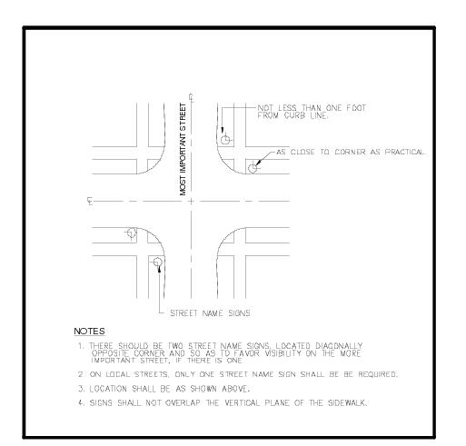
Figure 5.44 Development Name Signs – I
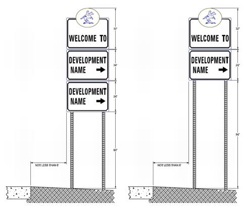
Figure 5.45 Development Name Signs – II
SPECIFICATIONS
SIGN BACKGROUND WILL BE
COVERED WITH HIGH INTENSITY TYPE LLL-
REFLECTIVE MATERIAL BLUE (3M
SCOTCHLITE 3875 OR EQUIVALENT).
CAESAR RODNEY BACKGROUND WILL
BE HIGH INTENSITY TYPE LLL YELLOW (3M SCOTCHLITE
3871) AND RIDER AND BORDER WILL BE BLUE
(3M SCOTCHLITE 3875 OR EQUIVALENT).
SIGN LEGEND AND BORDER WILL BE
HIGH INTENSITY TYPE LLL SILVER
(3M SCOTCHLITE 3870 OR EQUIVALENT).
LETTERING IS 5" HIGHWAY GOTHIC "C"
SIGNS BLANKS WILL BE
MANUFACTURED FROM .080" COATED ALUMINUM.
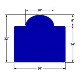
6.1 Chapter Purpose
This chapter addresses the permit application process, Notice to Proceed (NTP), and inspection and acceptance procedures for construction of commercial sites, subdivision streets (including industrial streets), and off-site improvements.
Implementation of these procedures will ensure that construction within the State right-of-way is in compliance with these Standards and Regulations for Subdivision Streets and State Highway Access, Standard Specification, Standards Construction Details, Construction Manual and other applicable DelDOT standards.
6.2 Utilities
Any proposed utility work within the right-of-way of a State-maintained roadway shall require a permit in accordance with the Utilities Design Manual prior to the start of construction.
Upon completion and acceptance of the subdivision or industrial streets, the utilities that are located within the State right-of-way shall be franchised in accordance with the existing countywide blanket agreement for each individual utility.
The proposed utilities within a new subdivision or industrial street shall be shown on the construction plans as outlined in Chapter 4.
Where feasible, underground utilities shall be placed behind the proposed curb line or in an established utility easement. Utilities that must be located within the dedicated right-of-way shall be installed in accordance with the DelDOT Utilities Design Manual.
Utility conflicts with future subdivision street construction shall be corrected by the utility company or the developer at no expense to the State. Any modification to the proposed utility locations shall be reflected on the as-built plans.
Requests for utility permits must be submitted with plans to the Public Works Engineer in the respective county as indicated in Figure 6-1.
Figure 6.1 DelDOT Public Works Engineers
New Castle County (DelDOT Canal District) Public Works Engineer 250 Bear-Christiana Road Bear, DE 19701 |
Kent County (DelDOT Central District) Public Works Engineer 930 Public Safety Blvd. Dover, DE 19901 |
Sussex County (DelDOT South District) Public Works Engineer 23697 DuPont Boulevard P.O. Box 490 Georgetown, DE 19947 |
6.3 Commercial Entrance Permit
6.3.1 Application Process. This section outlines the application process for the construction of commercial entrances. Prior to issuance of permit for entrance construction the following documents must be submitted to the Public Works Engineer for review and approval:
6.3.1.1 An application for commercial entrance permit (see Appendix E).
6.3.1.2 Proof of ownership from the local land use agency (this must be an official document or on letterhead from the local land use agency) or an affidavit indicating property owner’s name and Tax Map I.D. Number.
6.3.1.3 If the applicant is not the current property owner, the power of attorney form in Appendix E must be completed and included in the application. The Power of Attorney form is not used to issue the permit to someone other than the property owner. It just allows someone else to sign for the permit. The permit holder is still the property owner.
6.3.1.4 A copy of the site plan recorded by the local land use agency.
6.3.1.5 Two sets of construction drawings that have been approved by DelDOT’s Subdivision Engineer.
6.3.1.6 The itemized construction cost estimate. See Figure 4-2 for a sample cost estimate.
6.3.1.7 A security in the amount of 100 150% of the approved construction cost estimate. The following forms of security shall be acceptable:
The approved security forms are provided in Appendix E.
6.3.1.8 Approval letter from the Conservation District, if construction occurs in Kent or Sussex County.
6.3.2 Notice to Proceed (NTP). After review and approval of the documentation and security, the Public Works Engineer will evaluate the following items prior to issuance of permit for entrance construction which shall serve as the NTP:
6.3.2.1 Preconstruction Conference – The Public Works Engineer will determine if a preconstruction conference is needed prior to issuance of the NTP. The preconstruction conference shall be scheduled by the Public Works Engineer or his/her designee and attended by appropriate representatives of DelDOT, the developer, his/her engineer, and contractor, utility firms and such other agencies as may be deemed appropriate. Items to be discussed at this meeting may include, but are not limited to, the following:
6.3.2.2 Utility Coordination.
6.3.2.3 Material Testing.
6.3.2.4 Construction Schedule.
Once the Public Works Engineer is satisfied with the items listed above, the permit for entrance construction will be issued.
6.3.3 Inspection and Acceptance
DelDOT reserves the right to inspect and approve any construction associated with the proposed entrance in accordance with Section 6.8 and the inspection procedures in DelDOT’s Construction Manual.
DelDOT also reserves the right to make such changes, additions, and relocations to the approved entrance plans that may be considered necessary to ensure compliance with any applicable design standards and ensure the safety of the traveling public.
A final inspection shall be held by the inspector and may include the Public Works Engineer to verify that the entrance was constructed in accordance with DelDOT standards. Once DelDOT is satisfied with the construction, the inspector shall recommend final acceptance and the release of the security by the Public Works Engineer. The local land use agency shall be notified prior to final acceptance.
In the event of failure to perform the intended construction in accordance with the terms of the commercial entrance permit as determined by DelDOT, the developer shall receive written notice and have fourteen calendar days to provide DelDOT with an approved schedule for completion. If a schedule for completion has not been received within the specified time period, the developer shall receive a second written notice and have an additional seven calendar days to meet in person with DelDOT and present an approved schedule for completion.
Should the developer fail to provide a satisfactory construction schedule or fail to comply with the approved completion schedule, DelDOT shall withdraw its permit and shall have the right to utilize collect the 100 150% construction security to correct the condition. All costs incurred in the removal and/or correction of defective workmanship and/or materials over and above the construction security shall be borne by the applicant.
6.3.4 Maintenance
After the entrance has been constructed to the satisfaction of DelDOT and the commercial entrance permit has been issued, the property owner shall be responsible for the repair of any deficiencies within the entrance for a period of one year. Deficiencies identified by DelDOT shall be repaired in accordance with DelDOT’s Construction Manual. If repairs are not initiated within three months of notification, then DelDOT shall void the commercial entrance permit and access to the property shall be denied.
DelDOT shall assume the responsibility for future normal maintenance of the entrance within the shoulder area and any necessary cleaning or replacing of drainage pipe, and guardrail repair within the right-of-way. Entrance appurtenances beyond the edge of shoulder are the responsibility of the property owner for maintenance. This includes any traffic control signs (i.e., Stop or Yield) that may need future maintenance. Should the applicant, heirs, or assigns desire to alter or reconstruct any portion of the entrances or appurtenances, application for a new permit must be submitted to DelDOT for approval.
6.4 Subdivision Streets
6.4.1 Application Process. This section outlines the application process for the construction of new subdivision streets dedicated for public use and intended for acceptance into State maintenance. Prior to issuance of a NTP the following documents must be submitted to the Public Works Engineer for review and approval:
6.4.1.1 The subdivision site plans recorded by the local land use agency.
6.4.1.2 Letter from the DelDOT Subdivision Engineer stating that the entrance plans are substantially complete and a preconstruction conference can be scheduled by the Public Works Engineer.
6.4.1.3 Subdivision Construction drawings with most recent revisions (six copies).
6.4.1.4 A security in the amount of 10% of the estimated street construction cost using the security determination chart in the construction agreement for subdivision streets (see Appendix F). Hot mix prices shall be itemized and submitted with the construction agreement.
6.4.1.5 A security in the amount of 100% of the estimated cost to construct the main entrance. This security applies to construction of auxiliary lanes, roadway widening, and other modifications to existing State-maintained roadways. If no auxiliary lanes, roadway widening, or other improvements are required then this portion of the security may be waived.
The following forms of security shall be acceptable:
The approved security forms for subdivision streets are provided in Appendix F. The security forms for subdivision entrances are the same forms for the commercial entrances.
6.4.1.6 Completed construction agreement for subdivision streets (see Appendix F).
6.4.2 Notice to Proceed (NTP). After review and approval of the construction agreement and security, the Public Works Engineer will address the following items prior to issuance of the NTP:
6.4.2.1 Preconstruction Conference – The Public Works Engineer will determine if a preconstruction conference is needed prior to issuance of the NTP. The preconstruction conference shall be scheduled by the Public Works Engineer or his/her designee and attended by appropriate representatives of DelDOT, the developer, the developer’s engineer and contractor, utility firms and such other agencies as may be deemed appropriate. Items to be discussed at this meeting may include, but are not limited to, the following:
Following approval of the required submissions and a successful preconstruction conference, the Public Works Engineer shall issue the NTP, allowing the developer to proceed with clearing and grading on bonded streets. No construction materials (such as graded aggregate base course, hot-mix or drainage pipe) can be placed until after the construction plans of the subdivision drawings are stamped "APPROVED" by the DelDOT Subdivision Engineer.
The developer may proceed with clearing and grading at its own risk for a period of thirty calendar days, prior to final approval of subdivision construction plans by the DelDOT Subdivision Engineer. If final approval is not received within thirty calendar days of the NTP, all construction activities shall be stopped and the NTP shall be withdrawn.
Once the DelDOT Subdivision Engineer approves the subdivision construction drawings, two complete full-size and two complete half-size sets of construction drawings shall be forwarded to the Public Works Engineer. The drawings must have the approval stamp of the DelDOT Subdivision Engineer.
Upon receipt of approved construction drawings, the Public Works Engineer will issue a final "Notice to Proceed" letter, allowing the Developer to proceed with permanent street construction within the subdivision.
Construction of the entrance to the subdivision shall be started prior to the 50th 1st building permit or 25% of the subdivision whichever is less. Once construction has started on the roadway it must be actively pursued until completed remain active until completed up to the final lift of asphalt. The entrance may be required to be built sooner at the discretion of the Public Works Engineer.
6.4.3 Inspection and Acceptance
DelDOT reserves the right to inspect and approve any construction associated with the proposed subdivision in accordance to Section 6.8 and the inspection procedures outlined in the DelDOT Construction Manual.
DelDOT also reserves the right to make such changes, additions, and relocations to the approved plans that may be considered necessary to ensure compliance with any applicable design standards and ensure the safety of the traveling public.
Upon completion of the subdivision streets within a given phase of construction, if phased, the developer shall request a final inspection of the work. The final inspection shall be attended by appropriate DelDOT personnel and shall generate a final punch list of outstanding items that must be completed by the developer.
Upon completion of the punch list to the satisfaction of DelDOT and the submission of the following documents, the Public Works Engineer shall recommend that the streets be accepted into the State maintenance system.
Should the developer fail to satisfactorily complete subdivision street construction in accordance with the construction agreement for subdivision streets as determined by DelDOT, the developer shall receive written notice and have fourteen calendar days to provide DelDOT with an approved schedule for completion. If a schedule for completion has not been received within the specified time period, the developer shall receive a second written notice and have an additional seven calendar days to meet in person with DelDOT and present an approved schedule for completion.
Should the developer fail to provide a satisfactory street construction schedule or fail to comply with the approved completion schedule, DelDOT may withdraw its approval to construct the affected subdivision streets and shall draw upon the security as outlined in the security agreement.
Withdrawal of subdivision street construction approval for failure to complete the streets shall be cause to increase the required construction security from 10% to 100% on future subdivision street construction projects requested by the defaulting applicant.
Following completion of street construction and submission of required documentation to the satisfaction of the District Engineer, the Subdivision Engineer shall prepare an “Acceptance Drawing and an Acceptance Statement” and recommend acceptance of the streets. The Subdivision Engineer shall approve and sign the acceptance documents for DelDOT and shall notify the local land use agency and local legislators that the streets have been accepted.
Upon acceptance of the streets into the State maintenance system, an entrance permit shall be required for each new entrance to the street as outlined in Chapter 7. The applicant shall be responsible for damage to the curb, gutter, shoulders, and drainage affected by any entrance construction.
In subdivisions where residential streets and cul-de-sacs have been completed and the collector street serving them is complete except for the final lift of hot-mix, the developer shall submit the completed residential streets and cul-de-sacs for acceptance. Additionally, the developer shall provide:
6.4.3.1 Road Number Assignment. The Planning Section shall assign maintenance road numbers to the subdivision streets following acceptance by DelDOT.
6.4.4 Maintenance. Upon acceptance of the streets into the State maintenance system, DelDOT agrees to the following limited maintenance responsibilities:
6.4.4.1 DelDOT agrees to maintain the following elements within the dedicated right-of-way or easements:
6.4.4.1.1 The paved portion of the roadway.
6.4.4.1.2 Curbing and gutters.
6.4.4.1.3 Closed drainage system including inlets and pipes that conveys roadway runoff.
6.4.4.1.4 Open ditch systems, including entrance pipes, located within the right-of-way and easements that conveys roadway runoff.
6.4.4.1.5 Guardrails.
6.4.4.2 While retaining all controls over the dedicated right-of-way, DelDOT assumes no responsibility for:
6.4.4.2.1 Maintenance of grass and plantings in any portion of the right-of-way, including landscaped islands and medians.
6.4.4.2.2 Removal of silt and debris that have a minimal impact on the drainage system in open swales, gutters and inlet openings.
6.4.4.2.3 Removal and maintenance of future improvements by residents, such as landscaping, underground sprinklers, signs, etc. not shown on the as-built plans.
6.4.4.2.4 Maintenance of sidewalks, lighting, and entrance amenities.
6.4.4.2.5 Actual removal of snow and ice – DelDOT offers reimbursement of snow removal expenses through the “Snow Reimbursement Program.”
Alleys should be used within the subdivision street layout in accordance with appropriate subdivision design principles and the requirements of local land use ordinances. While DelDOT encourages the appropriate use of alleys in subdivision street layout, DelDOT shall not accept any maintenance responsibilities for alleys in the public right-of-way.
A permit from DelDOT shall be obtained for any modification to the roadway, curb, sidewalk, or drainage ditches within the right-of-way.
6.5 Industrial Streets
6.5.1 Permit Application Process. The permit application process for industrial streets follows the same procedures as subdivision streets presented in Section 6.4.1.
6.5.2 Notice to Proceed (NTP). Requirements for obtaining a NTP for industrial streets follow the same procedures as subdivision streets presented in Section 6.4.2.
6.5.3 Inspection and Acceptance
The developer is responsible for providing inspection of the bonded industrial park streets as per the construction agreement. The developer's engineer shall be certified by the DelDOT Consultant Control Committee to perform construction engineering.
Upon completion of the industrial park streets within a given phase of construction, if phased, the developer shall request a final inspection of the work. The final inspection shall be attended by appropriate DelDOT personnel and shall generate a final punch list of outstanding items that must be completed by the developer.
Upon completion of the punch list to the satisfaction of DelDOT and the submission of the following documents, the Public Works Engineer shall recommend that the streets be accepted into the State maintenance system.
6.5.3.1 As-built construction plans – The as-built construction plans shall be a print of the approved construction plan annotated in red to show all revisions necessitated by field conditions. The developer's engineer shall prepare this plan and submit it to the Public Works Engineer or his/her designee prior to the issuance of the letter recommending acceptance.
In addition, the developer’s engineer shall also submit an electronic plan version of the as-built construction plans for the entire industrial park streets to the Public Works Engineer or his/her designee. See Chapter 4 for electronic plan submission requirements.
6.5.3.2 A letter from the local land use agency stating that all work required by the land use agency is complete.
6.5.3.3 A letter from the local Conservation District stating that all work required by the conservation District is complete (if applicable).
6.5.3.4 A letter to DelDOT from the developer releasing DelDOT from any claims as a result of any unpaid bills or obligations. An affidavit releasing DelDOT is to be fully executed and furnished to the District Office prior to the issuance of the letter recommending acceptance. See Appendix F for a sample affidavit.
Should the developer fail to satisfactorily complete industrial park street construction in accordance with the construction agreement for industrial park streets as determined by DelDOT, the developer shall receive written notice and have fourteen calendar days to provide DelDOT with an approved schedule for completion. If a schedule for completion has not been received within the specified time period, the developer shall receive a second written notice and have an additional seven calendar days to meet in person with DelDOT and present an approved schedule for completion.
Should the developer fail to provide a satisfactory street construction schedule or fail to comply with the approved completion schedule, DelDOT may withdraw its approval to construct the affected industrial park streets and shall draw upon the security as outlined in the security agreement.
Withdrawal of industrial park street construction approval for failure to complete the streets shall be cause to increase the required construction security from 10% to 100% on future industrial park street construction projects requested by the defaulting applicant.
Following completion of street construction and submission of required documentation to the satisfaction of the District Engineer, the Subdivision Engineer shall prepare an “Acceptance Drawing and an Acceptance Statement” and recommend acceptance of the streets. The Engineer shall approve and sign the acceptance documents for DelDOT and shall notify the local land use agency that the streets have been accepted.
Upon completion of all aspects of the initial street construction to the satisfaction of the inspecting engineer, a first final inspection shall be held. After the first final inspection, a three- year waiting period is required prior to the acceptance of said streets into DelDOT's maintenance system. At this time a second final inspection shall be held to ensure that all punch list items from the first final inspection have been corrected and that the streets as designed have held up to the anticipated traffic loading. The three-year waiting period is required by DelDOT because of the significantly higher traffic volumes that are typically generated by an industrial park type development and the heavier vehicle loadings that are experienced by the high percentage of truck traffic.
Should the developer fail to satisfactorily complete industrial street construction in accordance with the construction agreement for industrial streets as determined by DelDOT, the developer shall receive written notice and have fourteen calendar days to provide DelDOT with an approved schedule for completion. If a schedule for completion has not been received within the specified time period, the developer shall receive a second written notice and have an additional seven calendar days to meet in person with DelDOT and present an approved schedule for completion.
Should the developer fail to provide a satisfactory street construction schedule or fail to comply with the approved completion schedule DelDOT may withdraw its approval to construct the affected streets and shall draw upon the security as outlined in the security agreement.
6.5.4 Maintenance. Upon acceptance of the streets into the State maintenance system, DelDOT agrees to the following limited maintenance responsibilities:
6.5.4.1 DelDOT agrees to maintain the following elements within the dedicated right-of-way or easements:
6.5.4.1.1 The paved portion of the roadway.
6.5.4.1.2 Curbing and gutters.
6.5.4.1.3 Closed drainage system including inlets and pipes that conveys roadway runoff.
6.5.4.1.4 Open ditch systems, including entrance pipes, located within the right-of-way and easements that conveys roadway runoff.
6.5.4.1.5 Guardrails
6.5.4.2 While retaining all controls over the dedicated right-of-way, DelDOT assumes no responsibility for:
6.5.4.2.1 Maintenance of grass and plantings in any portion of the right-of-way, including landscaped islands and medians.
6.5.4.2.2 Removal of silt and debris that have a minimal impact on the drainage system in open swales, gutters and inlet openings.
6.5.4.2.3 Removal and maintenance of future improvements by residents, such as landscaping, underground sprinklers, signs, etc. not shown on the as-built plans.
6.5.4.2.4 Maintenance of sidewalks, lighting, and entrance amenities.
6.5.4.2.5 Actual removal of snow and ice.
6.5.4.2.6 Permit to change
6.6 Off-Site Improvements (Public Road Construction)
6.6.1 Application Process
During the land development process, DelDOT may determine the need for road improvements beyond the entrance to the site. These improvements shall be required as part of the entrance approval. The developer shall enter into an agreement with DelDOT outlining the implementation of the improvements. This may be for the actual design, construction, and inspection of the improvements, or monetary contribution for the actual construction of the improvements. This agreement shall be executed prior to entrance plan approval. See Appendix B for regulations regarding improvements requiring new rights-of-way.
If a proposed development triggers the need for improvement to the abutting State-maintained roadway beyond the entrance, the following documents shall be obtained and submitted prior to the start of construction.
6.6.1.1 Approved roadway construction drawings (six copies). Refer to DelDOT’s publications and forms web page for the checklist for offsite plan development (www.DelDOT.gov).
6.6.1.2 Construction agreement for public roads (off-site improvements).
6.6.1.3 The itemized cost estimate. See Figure 4-2 for a sample cost estimate.
6.6.1.4 Prior to DelDOT issuing a NTP for the construction of the offsite improvements the developer shall provide DelDOT with a security in the amount of 100% of the estimated construction cost as approved by DelDOT.
The approved security forms are provided in Appendix H.
6.6.2 Notice to Proceed (NTP). The following requirements must be fulfilled before DelDOT issues a NTP for off-site improvements:
6.6.2.1 Approved construction plans and estimates.
6.6.2.2 Executed construction agreement for public roads (off-site improvements) by the Subdivision Engineer for DelDOT.
6.6.2.3 Security for the proposed work.
6.6.2.4 A preconstruction conference shall be scheduled by the Public Works Engineer or construction group engineer and attended by appropriate representatives of DelDOT, the developer, the developer’s engineer and contractor, utility firms and such other agencies as may be deemed appropriate. Items to be discussed at this meeting may include but are not limited to the following:
Following approval of the required submissions and a successful preconstruction conference, the Public Works Engineer or DelDOT’s Construction Group Engineer shall issue the NTP.
6.6.3 Inspection and Acceptance. Off-site improvement projects are divided into three levels based on their size and impact on the abutting State-maintained roadway. This categorization helps DelDOT identify the level of involvement with each project, and what division will manage the construction of the project. Figure 6-2 summarizes the three levels of classification for off-site inspection and acceptance
Figure 6.2 Off-Site Inspection and Acceptance
Level | AADT | Impact | Inspection |
Level I | < 2000 veh/day | Construction has no or minimal impact to the traveling public. | DelDOT will provide inspection for Level I projects through the Public Works Section in accordance with the construction agreement and DelDOT’s Construction Manual. |
Level II | 2000 – 10,000 veh/day | Construction has some impact to the traveling public. | An engineering firm hired by the developer performs inspection. The developer's engineer shall be certified by the DelDOT Consultant Control Committee to perform construction inspection and engineering. DelDOT’s Public Works will coordinate construction inspection. |
Level III | >10,000 veh/day | Construction has significant impact to the traveling public | The developer will be required to enter into a construction inspection agreement with an inspection firm currently under contract with DelDOT. Division of Transportation Solutions will coordinate inspection. |
Note: All work shall be in accordance with the construction agreement and DelDOT’s Construction Manual. | |||
The following roles and responsibilities shall apply to both Level II and III impacts:
6.6.3.1 Project Assignment of Personnel
Project staff shall be adequate in number, with appropriate qualifications to control the work in a manner consistent with sound engineering and construction practices. A project supervisor, assigned by the inspecting engineering firm, shall administer the project on behalf of DelDOT and shall be responsible for the implementation of all applicable practices and procedures outlined in Part D “Field Practices and Procedures” of DelDOT’s Construction Manual. Failure to comply shall result in removal of project staff and stoppage of all construction activities until project staffing requirements are met.
The presence of inspection personnel is required during any and all roadway work within existing or proposed public right-of-way at all times. If the inspecting engineering firm fails to provide required project personnel, DelDOT will provide construction inspection personnel. DelDOT’s total construction inspection personnel costs, including salaries, benefits, and related expenses shall be completely funded by the developer. Any changes in key project management personnel shall be immediately brought to the attention of DelDOT.
6.6.3.2 Inspection
During the progress of all associated construction work under the project, the inspecting engineering firm shall furnish appropriate field inspection of workmanship and material usage at the site of the work during the period that the work is actually being performed to determine and verify conformity of all work to the plans and specifications. This shall include inspection of construction equipment to determine conformity with the contract specifications outlined in Part D “Field Practices and Procedures” of DelDOT’s Construction Manual.
DelDOT will provide materials inspection and testing services. This work shall include, but not be limited to, concrete testing, asphalt concrete testing, and soils testing. The inspecting engineering firm is responsible for documenting material inspections and tests that have been performed at the project site. This includes the collection of all load tickets for review. All loads must comply with the established DelDOT load restrictions.
6.6.3.3 Field Reports. All inspectors shall submit written daily reports and field notes to the project supervisor. These reports shall be retained in the field files for reference. A project diary shall also be maintained for the project.
6.6.3.4 Progress Meetings and Schedule. The project supervisor shall schedule a monthly progress meeting. The required attendees include:
A bi-monthly construction schedule is required to be completed by the contractor and submitted by the project supervisor to the DelDOT Construction Group Engineer on the last day of every workweek during project construction.
6.6.3.5 Directives and Coordination
General – The Contractor is required to comply with any and all directives made by the project supervisor. Failure to comply shall result in the project supervisor contacting, in writing, DelDOT’s Construction Engineer. Based on the severity of the infraction, failure to comply may also result in a DelDOT-directed stoppage of work on the project.
Maintenance of Traffic (MOT) / Erosion and Sediment Control (E&S) – The project supervisor shall be responsible for the coordination of all MOT and all requests that may be made by DelDOT personnel. These requests are to be implemented immediately and considered part of the project. A failure to comply may result in a DelDOT-directed stoppage of work on the project.
Public Relations – The project supervisor shall contact the Public Relations Section with contact information pertaining to the work prior to the start of construction. The project supervisor shall coordinate the response to any public inquiry with DelDOT’s Construction office.
Two-Week Advanced Notice – The project supervisor shall coordinate any major MOT operations with DelDOT’s Construction office. Two weeks advanced notice shall be provided to DelDOT’s Construction office prior to any anticipated road closure or traffic shift. A failure to comply may result in a DelDOT-directed stoppage of work on the project.
6.6.3.6 As-Built Plans. For the preparation of as-built plans, the inspecting engineering firm shall retain one set of record prints of the construction plans. These shall be kept up-to-date by the substitution of revised plan sheets by marks for minor changes that have been made, and by notes from the inspector’s diary. The as-built plans shall show in red ink any alterations made in foundations; locations, lengths and elevations of pipe culverts; side ditches, ditch paving, and other drainage items added or altered; final checked stationing; and all other significant variations from the original plans. As-built plans will be required as part of the final acceptance of the off-site improvements.
6.6.3.7 Shop Drawings
The project supervisor shall handle the distribution and coordination for review of shop drawings. DelDOT must approve all shop drawings.
Upon completion of all aspects of the initial street construction to the satisfaction of the inspecting engineer, a first final inspection shall be held. Upon completion of all work to the satisfaction of DelDOT, the developer will be released of liability and the roadway work will be accepted. The local land use agency shall be notified when the work has been accepted.
6.7 Construction Responsibilities. The following outlines the applicant’s construction responsibilities:
6.7.1 Pavement Placement Guidelines
The first lift of hot mix shall be placed no later than 18 months from the NTP or the beginning of the second winter after the NTP.
The final wearing course of hot mix on subdivision streets shall not be placed until 75% of the houses contributing traffic to those streets have been completed or as directed by the Public Works Engineer.
Prior to placing the pavement sections, the subgrade shall be prepared and test-rolled as detailed in DelDOT’s Standard Specifications. If the test rolling shows the subgrade to be unstable, the contractor shall scarify, disc, aerate or add moisture and recompact the subgrade to the extent that when retested it shall be stable. If, in the opinion of the Public Works Engineer or the Construction Engineer, there are areas to be removed or undercut, they may be ordered excavated and replaced with approved material.
6.7.2 Work Hour Restrictions
When a developer determines that it would be best to undertake construction / reconstruction work after 9:00 pm or before 7:00 am, and such work is to be conducted immediately adjacent to a residential neighborhood, the developer shall first ensure that residents of the neighborhood are notified in a timely fashion of the desire to undertake such work. The developer shall prepare a notification explaining the benefits and costs to the neighborhood of working under regular hours and the proposed extended hour schedule. Such notification shall include:
The developer may proceed with its extended work hours if it secures approval from a majority of the residents of the affected neighborhood.
If DelDOT determines that the proposed work (regardless of its scheduled time) will produce noise that exceeds that applicable noise ordinances of the appropriate jurisdiction, the developer shall ensure that it seeks and receives a waiver from that jurisdiction before commencing work.
If DelDOT determines that the proposed work may cause any vibration or other damage to neighboring property, the developer shall complete a pre-work survey of the potentially affected properties to determine the baseline condition of those properties. The developer shall monitor the properties during construction to ensure that any vibration or other damage is minimized. If any damage does occur, the developer is responsible to reimburse the property owners.
DelDOT may waive the provisions of this section if it is determined that any such work is necessary in order to respond effectively to an emergency caused by a natural disaster or an accident.
6.8 Inspection
The developer shall provide the District Engineer or his/her designee, access to all parts of the work and furnish such information and assistance as is required to make a complete and detailed inspection as described in DelDOT’s current Standard Specifications.
During construction, the developer shall provide the District Engineer or his/her designee with at least two working days notice of all major construction activities. These activities shall include, but are not limited to, the following:
A DelDOT Inspector must be present during these construction activities. All materials shall be inspected, tested, and approved before being incorporated in the work in accordance with DelDOT’s Standard Specifications Section 106 – Control of Material.
All inspection of paving materials used and placement of paving materials shall be placed in accordance with the Contractor’s Quality Control (QC) Plan. The Contractor’s QC Plan shall be prepared in accordance with DelDOT’s Special Provision 401699 – Quality Control/Quality Assurance of Hot-Mix Asphalt.
Credit for Hot-Mix Asphalt (HMA) – If the Contractor constructs any pavement that does not meet the requirements outlined in the contract documents, the developer’s HMA will be required to provide DelDOT a certified check for future pavement maintenance based on the amount of pavement that does not meet the specifications. The amount of the certified check will be equal to the average bid prices of the pavement minus the cost of the pavement that does not meet the requirements of the contract documents.
Assessment for Future Maintenance = (Tonnage of HMA in question) x Pavement Bid 
The percent compliant is based on the procedures outlined in DelDOT’s Special Provision 401699 – Quality Control/Quality Assurance of Hot-Mix Asphalt. The percent compliant is broken down into the amount of material production pay adjustment and the pavement construction pay adjustment. The material production is 70% of the pavement cost and the pavement construction is 30% of the pavement cost. The payment is calculated for each lot tested. The pay adjustment is discussed in greater detail in Special Provision 401699.
Credit for PCC – The PCC credit shall be consistent with DelDOT’s Standard Specifications section 602.25.
The Developer shall request a final inspection when all work is complete. The District Engineer or his designee may then schedule a final inspection which shall be conducted by the District. DelDOT personnel, accompanied by the developer and/or his/her contractor, and representatives of the appropriate County Public Works or Engineers Office, shall inspect the site and determine those items of work, if any, that must be either completed, replaced or repaired.
The District Engineer shall then provide the developer with a punch list of the remaining work within ten working days. The punch list shall include required letters or documents indicated under Acceptance. Should the developer fail to request a final inspection, the District Engineer may at his sole discretion provide to the developer a punch list of the remaining work to complete the streets.
The developer shall obtain a sign-off letter from the District Engineer indicating all work is complete before the roadway is accepted into the State maintenance system.
6.8.1 Inspection of Closed Drainage System
To assure that the storm drainage systems of subdivisions are constructed per DelDOT’s Standard Specifications prior to acceptance into the State maintenance system, a digital video inspection and report, verifying acceptability of the system, shall be required.
The procedure for inspecting closed drainage systems shall follow DelDOT’s Standard Specifications.
6.8.2 Inspection Fee
Pending review and approval of the Delaware General Assembly, DelDOT shall collect inspection fees on all new commercial entrance and subdivision street construction projects, built on the public right-of-way, whether seeking State-maintenance or not. When fees are collected they shall be collected from the project developer or owner prior to the start of any aspect of entrance or street construction. The fee shall be made payable to DelDOT, at the rate of 10% of the estimated cost of construction as approved by DelDOT for the involved streets. This fee shall be valid for cover a period of five years from the date of the NTP. If construction is not completed within the five-year period, an annual renewal fee of one quarter the current inspection fee shall be required. This fee must be paid at the beginning of each additional year of construction. NTP with initial construction shall not be issued until DelDOT has collected the inspection fee.
If a developer fails to comply with the renewal fee requirements within 100 days of receipt of written notification, DelDOT shall initiate forfeiture of the security bond.
NTP on additional entrance or street construction projects within a development shall not be issued until all outstanding inspection fees have been collected.
7.1 Chapter Purpose
This chapter describes standards and regulations associated with residential lots abutting State-maintained roadways. Access from residential lots has an impact on the mobility, safety, and efficiency of the abutting roadway. Control of these access points is necessary to maintain safety and increase efficiency of State-maintained roadways while allowing access to individual properties.
Residential access permits are issued by the Public Works Engineer in the respective county. A new permit must be obtained whenever a new or expanded entrance is being requested. Figure 7-1 shows the mailing address for each county.
Figure 7.1 DelDOT Public Works Engineers
New Castle County (DelDOT Canal District) Public Works Engineer 250 Bear-Christiana Road Bear, DE 19701 |
Kent County (DelDOT Central District) Public Works Engineer 930 Public Safety Blvd. Dover, DE 19901 |
Sussex County (DelDOT South District) Public Works Engineer P.O. Box 490 23697 DuPont Boulevard Georgetown, DE 19947 |
7.2 Residential Access. Property owners of single residential lots wishing to gain access to a local road or a higher classification road according to Functional Classifications (see Appendix K), or a subdivision street already accepted into the State maintenance system shall adhere to the following criteria detailed in this section.
7.2.1 Permit Application Process. The following documentation must be provided when applying for a residential entrance permit or access to a State-maintained road:
7.2.1.1 Any individual desiring to construct or reconstruct an entrance to serve a private single-family residence shall make written application to DelDOT in the District in which the construction is to take place before beginning any construction improvements on the property. The application form is available from the Public Works Engineer. A sample copy is provided at the end of this chapter.
7.2.1.2 The applicant shall include a plan, such as a Lines and Grades Plan, for the single residential lot. The plan shall fully comply with the local land use agency’s most recent recorded plan (if any) for the site. The plan shall include sufficient detail including:
7.2.1.3 The applicant shall include with the application proof of ownership from the local land use agency in the form of an official document on letterhead.
7.2.1.4 If the applicant is not the current property owner the power of attorney form must be attached with the application. See Appendix E for a sample power of attorney form.
7.2.1.5 The property owner must identify the proposed or existing entrance location. If the residential lot is part of a minor subdivision, a copy of the recorded minor subdivision plan must be included with the application form. If the entrance location has been identified on a recorded plan, the applicant shall stake it accordingly. Otherwise, the applicant shall stake the preferred entrance location. In either case, follow the procedure below:
7.2.1.6 Upon review and approval of the application and the actual driveway location, the Public Works Engineer shall issue an entrance permit for the construction of the residential entrance. The design requirements outlined in Section 7.2.3 must be met by the applicant.
7.2.2 Construction Responsibilities
The property owner shall be responsible for all costs associated with driveway installation including drainage pipe, drainage pipe placement, excavation and backfill, and placing driveway materials. DelDOT will determine if any drainage pipe is necessary and notify the property owner with the size of pipe required.
The property owner shall coordinate with DelDOT for the inspection of the pipe placement, if required.
Should the construction not be completed to the satisfaction of DelDOT, the Department may seek compliance as permitted by the Delaware Code including the closing of the entrance. All costs associated with obtaining compliance shall be assessed to the property owner.
7.2.3 Design Requirements. The following design criteria apply to residential access on non-subdivision streets and are illustrated in Figure 7-2.
7.2.3.1 Number of Access Points
No more than one point of access should be provided for each property. If the property frontage allows for the proper spacing as outlined in Figure 9-1, additional access points may be granted.
DelDOT may grant a second point of access to single residential lots in special circumstances. These special circumstances may include:
7.2.3.2 Entrance Location and Spacing
Spacing of residential access shall comply with the requirements outlined in Figure 9-1. If these minimum requirements cannot be met because of insufficient roadway frontage, then the applicant shall provide a combined access with the adjacent lot.
When a property has frontage on two roadways, the driveway shall be located on the lower volume road. See Section 9.2 for more information on entrance policy and access spacing.
7.2.3.3 Entrance Width. A single residential entrance shall have a width of ten to twelve feet. A combined residential entrance, serving two residential properties, shall have a width of 24 feet to 30 feet. Upon written request, DelDOT may consider entrance widths larger than those listed above to accommodate larger vehicles (See Figure 7-2).
7.2.3.4 Entrance Profile. Profiles of entrances and exits shall be designed in accordance with these Standards and Regulations for Subdivision Streets and State Highway Access, and AASHTO’s standards. Maximum grades shall not exceed 10%. Vertical curve transition shall be provided at the intersection of the driveway profile and the cross slope of roadway shoulder extended.
Figure 7.2 Residential Access Design Requirements
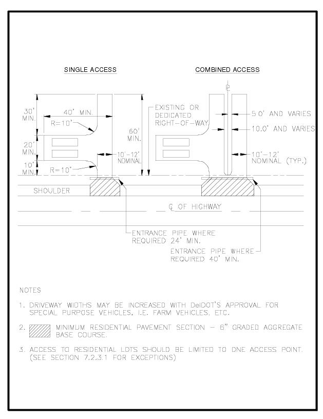
7.2.3.5 Entrance Drainage Pipe. Pipes are manufactured in various sizes, shapes, and materials. Entrance pipes commonly used in Delaware include:
Metal Pipes (MP) shall not be used in corrosive environments, such as areas with water tables that are tidally influenced, or other areas where MP’s have performed poorly. Use of MP must be approved by DelDOT prior to use.
Figure 7-3 Residential Entrance Pipes
Material | Cover Depth* | |
RCP Class | III | > 1 ft. |
IV | 6 in. – 1 ft. | |
V | < 6 in. | |
HDPE | 1 ft. | |
MP | 1 ft. | |
* From top of pipe to bottom of the flexible pavement.
The longitudinal slope from the entrance pavement to the top of the pipe shall be 6:1.
7.2.3.6 Entrance Apron
Aprons shall be placed on residential driveways to facilitate turning movements. Entrance aprons shall be designed in accordance with DelDOT’s current Standard Construction Details and Figure 7-4.
The area of the driveway between the edge of pavement for the State-maintained roadway and the right-of-way should be paved, but may be stabilized with graded aggregate base course as approved by the Public Works Engineer.
7.2.3.7 Entrance Turnaround. Driveways shall be designed to provide storage for vehicles off the State-maintained roadway right-of-way and include a provision for vehicular turnaround to enable entrance to the State-maintained roadway in a forward direction.
7.2.3.8 Sight Distance
Driveways shall be clear and free of obstruction. A driver shall have an unobstructed view of the adjacent roadway and the ability to view any approaching vehicles at the intersection with the roadway.
Design guidelines necessary to provide sufficient sight distance shall be in accordance with AASHTO and Section 5.4 of these Standards and Regulations for Subdivision Streets and State Highway Access.
7.3 Residential Access within Subdivision Streets. For residential access within subdivisions, the following criteria apply:
For sidewalk placement across driveways see Chapter 5 and the Standard Construction Details.
Figure 7.4 Entrance Apron
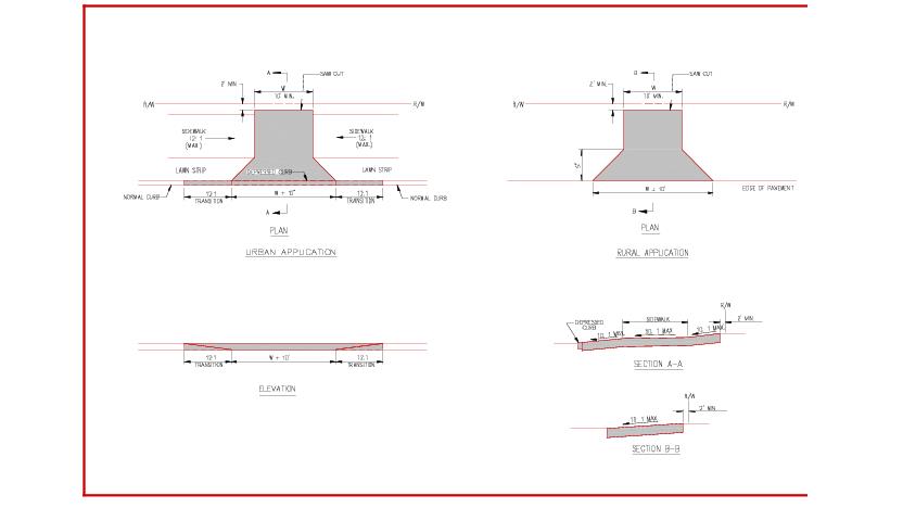
7.4 Mailbox Requirements. No mailbox or newspaper delivery box (hereafter referred to as mailbox) shall be allowed to exist on the State-maintained roadway right-of-way if it interferes with the safety of the traveling public or the function, maintenance, or operation of the State-maintained roadway. A mailbox installation that does not conform to the provisions of this regulation is an unauthorized encroachment.
7.4.1 Mailbox Installation. A mailbox installation that conforms to the following criteria shall be considered acceptable unless, in the judgment of DelDOT, the installation interferes with the safety of the traveling public or the function, maintenance, or operation of the State-maintained roadway.
7.4.1.1 Location
No mailbox shall be permitted where access is obtained from the lanes of a freeway or where access is otherwise prohibited by law or regulation.
Mailboxes shall be located on the right hand side of the roadway in the direction of the delivery route. The bottom of the box shall be set at an elevation established by the U.S. Postal Service, usually between 3.5 and 4 feet above the roadway surface.
On curbed streets the roadside face of the mailbox shall be set back from the face of curb distance between six and twelve inches. On roadways without curbs or all-weather shoulders and which carry low-traffic volumes operating at low speeds, the roadside face of a mailbox shall be offset between eight and twelve inches behind the edge of pavement.
Where a mailbox is located at a driveway entrance, it shall be placed on the far side of the driveway in the direction of the delivery route.
Where a mailbox is located at an intersecting road it shall be located a minimum of 100 feet beyond the center of the intersecting road in the direction of the delivery route. This distance shall be increased to 200 feet when the average daily traffic on the intersecting road exceeds 400 vehicles per day.
7.4.1.2 Structure
Mailboxes shall be of light sheet metal or plastic construction conforming to the requirements of the U.S. Postal Service. Newspaper delivery boxes shall be of light sheet metal or plastic construction of minimum dimensions suitable for holding a newspaper.
No more than two mailboxes may be mounted on a support structure. Lightweight newspaper boxes may be mounted below the side of the mailbox support.
A single 4”x 4” square or 4.5” diameter round wooden post or a metal post with a strength no greater than a 2” diameter standard strength steel pipe and embedded no more than 24 inches into the ground shall be acceptable as a mailbox support. A metal post shall not be fitted with an anchor plate, but it may have an antitwist device that extends no more than ten inches below the ground surface. Mailbox supports shall not be encased in concrete or brick.
The post-to-box attachment details should be of sufficient strength to prevent the box from separating from the post top if the installation is struck by a vehicle.
The minimum spacing between the centers of support posts shall be three-fourths the height of the posts above the ground line.
7.4.2 Removal of Non-Conforming or Unsafe Mailboxes
Any mailbox that is found to violate the intent of this regulation shall be removed by the postal patron upon written notification by DelDOT.
At the discretion of DelDOT, based on an assessment of hazard to the public, the patron shall be granted not less than 24 hours nor more than 30 days to remove an unacceptable mailbox. After the specified removal period has expired, the unacceptable mailbox shall be removed by DelDOT, at the postal patron’s expense.
Delaware Department of Transportation Application FOR Residential Entrance Construction Permit |
Property Owner’s Name :__________________________________________Date:______________ Mailing Address: ___________________________________________________________________ _____________________________, __________________________ __________________________ City State Zip Code Telephone No.: (______)_____________________ Cell No.: (______)_______________________ Fax No.: (______)___________________ E-mail Address: ________________________________ Tax Map I.D. No.: _________________________________________________________________ (Example: SM 00 000 00 00 00 00 000) |
Applicant Name:____________________________________________________________________ Mailing Address: ______________________________________________________________________, ____________________________ _______________________ City State Zip Code Telephone No.: (_______)____________________ Cell No.: (_____)________________________ Fax No.: (______)__________________ E-mail Address: _________________________________ |
Proposed/Existing entrance location (Mailing Address, Maintenance Road Name, or Road No.): ____________________________________________________________________________________ Nearest intersecting road (Name): ______________________________________________________ Distance from entrance to nearest intersecting road: _____________________________________Subdivision Name (If applicable): ________________________________________________________ Location of proposed entrance shall be physically staked in field with property owner’s name, as a condition of this application. Date when you can place stakes up at entrance: _____________________ If stakes are not in place, a permit will NOT be issued. mm/dd/yyAre you requesting a permit for an existing entrance or a proposed entrance? Existing or Proposed (Circle one) If applying for an existing entrance: * Will you be modifying or relocating the existing entrance? Yes __________ No _____________ If yes (explain): ______________________________________________________________________ * Was the existing entrance constructed within the past three years? Yes ________ No ________ Describe modification you are proposing on the property (Single Family Dwelling, Mobile Home, Replacement of Mobile Home, Echo Unit, Building, Additions, etc.): ____________________________ ____________________________________________________________________________________ Additional Comments (Please write on back) _____________________________ Signature |
8.1 Chapter Purpose
This chapter contains regulations for access to State-maintained roadways for conditions and occurrences not described thus far. These include temporary/seasonal entrances, construction entrances, special event sites, and access to extremely low volume generators such as utility sites. Controlling access to these sites enhances safety and increases throughput on the State-maintained roadway network.
Furthermore, policies associated with conversion of private streets to public roads, connector streets, and paper streets are discussed in this chapter.
8.2 Improper Entrances. Should DelDOT find that an entrance is in violation of these Standards and Regulations for Subdivision Streets and State Highway Access, the following actions shall be taken in order to gain compliance.
8.2.1 The Public Works Engineer shall notify the property owner by registered mail of the nature of the violation. The property owner shall be given 20 days from the date of the receipt of the notification to submit to DelDOT a schedule to correct the violation.
8.2.2 In the event that the property owner fails to correct the violation within the time specified or to comply with DelDOT’s request, the Public Works Engineer shall notify the Property owner by registered mail that the violation is to be corrected within ten days. Failure to comply with the second notification shall cause DelDOT to seek compliance in accordance with the remedies permitted by the Delaware Code, including closing the entrance. 8.2.3 All costs incurred by DelDOT incidental to obtaining compliance with these entrance requirements, including closing the entrance, shall be borne by the property owner.
8.3 Temporary / Seasonal Entrance for Business Purpose
When a parcel of land is to be occupied for business purposes for less than 90 days in any consecutive 12-month period, a temporary entrance permit may be issued in lieu of a permanent permit.
In order to secure a temporary permit, the applicant must show that sufficient off-street parking exists on the site as determined by local land use regulations. The applicant must provide a plan showing the parking area and the access point to the roadway, which must not interfere with the safe operation of auxiliary lanes.
Channelization shall be used to delineate the entrance. The channelization may consist of the following: barricades, cones, prefabricated temporary curbing or other temporary means approved by DelDOT.
The entrance, including the shoulder of the roadway, may be dirt or stone. The permit holder shall be responsible for maintenance of the entire entrance, the limits being defined on the temporary permit. The limits shall include the entrance up to the edge of the traveled way. Any ruts, potholes, etc. in the shoulder of the roadway in the vicinity of the entrance shall be the responsibility of the permit holder to repair. Failure to maintain the entrance area as defined shall cause DelDOT to make the necessary repairs. The entrance shall be closed by DelDOT until the permit holder reimburses DelDOT for the repairs and also posts a bond of sufficient amount to cover any future repairs. A permit shall not be issued to any individual, partnership, corporation, or other entity until all previous obligations created with DelDOT are fully satisfied.
8.4 Construction Entrance
If a property owner seeks to gain access to property for construction purposes and the final entrance plan has not been approved, the Public Works Engineer may issue a construction entrance permit.
A construction entrance permit does not relieve the applicant of the responsibility of obtaining a permit to construct a permanent entrance facility. The permit for construction of a permanent entrance facility shall be complete and accepted by DelDOT’s Public Works Engineer prior to utilization of the entrance. The requirement to obtain a surety for the construction entrance may be waived at the discretion of the Public Works Engineer.
8.5 Miscellaneous Entrance. Entrance permits are required for low volume entrances and special events such as used car sales, roadside stands, access to farm fields, and access to utilities. The process for obtaining the permit will follow the same process as a residential entrance permit outlined in Chapter 7.
8.6 Property Change of Use / Change of Ownership
If an existing business changes ownership and the existing Commercial Entrance Permit is still applicable, no new entrance permit will be required. If an existing property changes use or expands, the existing Commercial Entrance Permit shall be evaluated to determine if entrance improvements will be required. In either case, if If the traffic generated by the site exceeds the entrance design, then entrance modifications shall be required and plans shall be submitted as outlined in Chapters 3 and 5.
In the event that an entrance is approved, constructed, and at a later date an additional facility is constructed or the conditions change off the right-of-way in such a manner as to adversely affect the safe or proper use of the entrance, then DelDOT may require a new application or deny use of the entrance until such time as DelDOT is satisfied that the conditions are rectified.
8.7 Conversion of Private Streets to Public Streets. Private streets can be converted into public streets with or without being accepted into the State maintenance system.
8.7.1 Dedicating Streets to Public Use (State-Maintained). The following criteria shall be met in order for a street to be accepted into the State maintenance system:
8.7.1.1 The subdivision where the street is located shall meet the definition of a suburban community as defined in Chapter 1.
8.7.1.2 The homeowner’s association or a majority of the property owners must submit a written request for a roadway investigation, in accordance with State guidelines, to the Subdivision Engineer. The letter must give the State all necessary right of entry onto private property to perform the necessary investigations. A copy of the record plan shall accompany the letter.
Following the investigation, DelDOT will notify the homeowner’s association or property owners of the required work necessary to bring the streets up to State standards.
The homeowner’s association or property owners must have the current subdivision record plan re-recorded, dedicating the streets to public use.
The plan shall include the words “dedicated to public use” within the street right-of-way and the following note:
Subdivision streets constructed within the limits of the right-of-way dedicated to the pubic use, shown on this plan, are to be maintained by the State of Delaware at such time that the existing streets are brought up to current State standards and accepted by the State. The State assumes no maintenance responsibilities within the dedicated street right-of-way until the streets have been accepted by the State.
8.7.1.3 The following note must be included concerning the drainage / utility easement: The front and side ten feet of each lot hereon are reserved as easements for drainage and utilities unless otherwise noted.
8.7.1.4 A copy of the proposed record plan shall be submitted to the Subdivision Engineer, prior to recordation to ensure that all right-of-way and easements are correct. Once all comments have been addressed, DelDOT will issue a “No Objection to Recordation” letter to the local land use agency.
8.7.1.5 The homeowner’s association or property owners must submit construction plans as outlined in Chapter 4 for the reconstruction or the rehabilitation of the existing subdivision streets as determined in No. 2 above. Upon approval of the construction plans, the construction will be governed by Chapter 6 of these Standards and Regulations for Subdivisions Streets and State Highway Access.
8.7.1.6 Once DelDOT’s Subdivision Engineer has received a copy of the recorded plan showing plot book and page of recordation, and a letter from DelDOT’s Public Works Engineer stating all work has been completed to State requirements, the street will be accepted into the State maintenance system.
8.7.2 Dedicating Streets to Public Use (Not State-Maintained)
The following is the process for dedicating private streets that are not State-maintained to public use.
The homeowner’s association or property owners must have the streets dedicated to public use by either re-recording the record plan or other acceptable method of dedication. Once the roads have been dedicated to public use, they are eligible for improvements funded by the Community Transportation Program, at the request of local legislators.
8.8 Parking Within the Right-of-Way
8.8.1 Commercial. The development of a commercial property adjacent to State-maintained roadways shall include provisions for the required parking as specified by the local land use agency outside of the State-maintained roadway right-of-way. Parking is to be provided so as not to interfere or cause the backing up of traffic on the traveled-way as outlined in Chapter 3. Failure to provide the necessary parking area may result in the entrance being closed by DelDOT at the expense of the owner. Parking shall not be permitted on the shoulder of a State-maintained roadway or on any portion of the right-of-way located outside of a municipality.
8.8.2 Subdivision Streets
Parking is allowed within subdivision streets except in the following areas:
No driveways or parking bays shall be located in subdivisions within 40 feet from the edge of the radius return for the connecting street. This distance shall increase to 60 feet at the entrance to the subdivision.
In order to restrict parking in areas within a subdivision street that can accommodate overflow on-street parking, DelDOT will require support from a significant majority of the residents. DelDOT Traffic Unit Section must receive a petition signed by 75% of the households indicating their support for “Stopping, Standing, and Parking Restriction.” DelDOT will determine whether to restrict on-street parking within subdivision streets considering the petition and engineering study.
8.9 Paper Street Policy. The term “Paper Streets” refers to rights-of-way which have been recorded and dedicated to public use but in which no State-maintained streets have been built. In this way they differ from private streets where the rights-of-way have been dedicated and a street has been built but not accepted for State maintenance.
8.9.1 Guidelines For Access
DelDOT shall regulate access to properties fronting on paper streets as follows:
The minimum required pavement section shall be two inches of Type ‘C’ Hot Mix over eight inches of stone aggregate base material.
Bonding may not be required if it is determined that the street improvements are minimal and/or do not have any detrimental impact on the surrounding community should the applicant fail to complete its obligation. A security shall be required for performance, and shall be posted in the amount of 10% of the cost to construct the approved street improvements.
Generally, where two or more interconnected paper streets are involved, the Subdivision Section shall determine which paper right-of-way should be improved for access and, if appropriate, shall recommend to the District Engineer what street(s) should be barricaded
Following construction of the streets in accordance with approved construction plans , DelDOT agrees to accept for maintenance the paved portion of these streets including curbing and gutters, and open and closed drainage systems where they exist.
8.10 Connector Street. A connector street is a continuous street or streets entirely in the Subdivision Street category beginning and ending on the state numbered road system, and having a high volume of through traffic.
8.10.1 DelDOT may transfer certain connector streets into the state maintenance numbered road system. Transfer of connector streets from subdivision streets to maintenance road number designation changes the responsibility for funding from the legislator’s Community Transportation Funds to DelDOT’s Paving and Rehabilitation Work Programs. Guidelines: All streets in the subdivision street category are eligible for transfer, provided the minimum Annual Average Daily Traffic (AADT) along the length of the road must be above 4,000 vehicles.
8.10.2 Acceptance of resurfacing and reconstruction responsibilities for these roads in no way changes existing acceptance agreements which remain in full force and effect. When it comes to the attention of DelDOT that a subdivision street may meet criteria for transfer, the Division of Planning shall conduct a study to determine whether the criteria are met, and whether it is in the best interest of all concerned to effect the transfer. If the study supports the transfer, the Department shall hold a public meeting in the community to receive comments on the proposal. As a minimum, the following must be notified at least two weeks in advance of the meeting:
Within 30 calendar days of the public meeting, DelDOT shall decide which maintenance category the street shall be in and publicly notify the above-listed individuals/groups of that decision.
8.10.3 The responsibility for administration of these guidelines and certification of eligibility of roads rests with DelDOT’s Director of Planning.
8.11 Abandonment/vacation and/or closure of an existing road
This section provides the guidelines for determining the merits of considering a request for the abandonment/vacation and/or closure of an existing road or an interconnection.
When considering any request for abandonment/vacation and/or closure, an Operation Analysis as outlined in the Standards and Regulations for Subdivision Streets and State Highway Access, Section 3.9 shall be performed by the Applicant and made available to the local land use agency and DelDOT for review.
The following additional criteria shall be considered:
8.11.1 Safety, in terms of pedestrian, bicycle, motor vehicle and property owners,
8.11.2 Traffic volumes on the road in question would exceed the capacity of the roadway and the road cannot be reasonably modified to handle the increased volume of traffic,
8.11.3 How the closure/abandonment/vacation will affect access to the area via emergency vehicles, school buses, local service providers,
8.11.4 Whether the closure/abandonment/vacation is for the benefit of the health, safety and welfare of the public,
8.11.5 Affect of the closure/abandonment/vacation upon the local street and pedestrian network,
8.11.6 The Local Area Plan has been amended by the local jurisdiction through a public process to allow the closure, if applicable,
8.11.7 Affect of the closure/abandonment/vacation upon the provision of transit, including paratransit,
8.11.8 How the closure/vacation/abandonment will affect pedestrian and vehicular connectivity if it is rejected and if it is approved, and
8.11.9 How the proposal will affect access to, provision of, and maintenance on public utility systems such as drinking water, stormwater, sewer, electric and gas.
9.1 Purpose and Use
The number, spacing, type, and location of access and traffic signals have a direct and often significant effect on the capacity, speed, and safety of the highway. Access to the Functional Classification Network is controlled using a hierarchical five level category system. The design standards within each category are necessary to ensure that the highway will continue to function at the level (category) assigned. Each state highway segment is assigned a category as defined in Sections 9.3 to 9.7.
Traffic signals and their installation are guided by the Manual on Uniform Traffic Control Devices (Delaware MUTCD) and regulated by the DelDOT Traffic Section. DelDOT may at its discretion, grant an access to a State-maintained roadway, require design and operational modifications as it deems necessary, restrict one or more turning movements, or deny the access so long as such discretion does not violate relevant law.
The existing design of the highway is not required to meet the design standards of the assigned category at the time it is assigned. All new access permitting and other access design decisions shall meet the design standards in this chapter for the assigned category for the highway or segment of highway.
9.2 Entrance Policy
9.2.1 Location of Entrances
Entrances shall be placed to provide safe access to the site while providing the least impact on the existing roadway system. Entrances shall be located to provide the required sight distance, in accordance with AASHTO Standards, where the highway alignment and profile are favorable, where there are no sharp curves or steep grades, and where sight distance in conjunction with the access is adequate for safe traffic operation.
If a proposed development has frontage on two roads, access shall be provided from the lower volume road. Considerations for the placement of entrances should include evaluation of sight distance, location of adjacent entrances, and distance from intersecting streets. Where feasible, entrances shall not be located within 40 feet of an intersection radius or on acceleration and deceleration lanes.
Site circulation should be designed to allow vehicles to easily enter the site not blocking entrances and not be impacted by traffic control devices or parking spaces.
Any site being considered by DelDOT for access on to a State-maintained roadway shall be evaluated to determine if it will also impact any other DelDOT programs. These programs include, but are not limited to, the Corridor Capacity Preservation Program (CCPP), the Capital Transportation Program, the Transportation Enhancement (TE) Program, the Highway Safety Improvement Program (HSIP), Pavement Rehabilitation Program, and Community Transportation Fund Program. If a plan would have an affect on any of these programs, that fact may necessitate additional review by DelDOT and additional requirements may need to be met.
When feasible and practical, two adjacent commercial properties shall use a common ingress and egress from the public highway. The original property owner shall establish and record a cross access easement regarding the location and design of such ingress and egress prior to any sale or subdivision of land subject to the review and approval of DelDOT.
9.2.2 Number and Arrangement of Driveways
Spacing of residential access shall comply with the requirements outlined in Figure 9-1. If these minimum requirements cannot be met because of insufficient roadway frontage, then the applicant shall provide a combined access with the adjacent lot. Not more than two combined entrance and exit driveways on the same highway shall be provided to any single property tract or business establishment.
DelDOT may consider an exception only where the frontage is 1000 feet or more. In such instances and where exceptions are requested by the developer, DelDOT shall study the proposed driveway design and parking arrangement to determine if any exception may be granted from an overall highway traffic operation and safety standpoint.
9.2.3 Deeded Access Rights. Along some sections of State-maintained roadway, access rights have been obtained by DelDOT in the form of a recorded deed. Where access is controlled by deed there is no right of direct access through the deeded section. The property owner so affected may inquire with DelDOT about changes or purchase of any deeded access rights. The obtaining or revising of access rights by deed is regulated by the right-of-way acquisition process. Where access is not restricted by deed, an access permit consistent with the requirements of Standards and Regulations for Subdivision Streets and State Highway is still required for the construction and use of a driveway.
Figure 9.1 Spacing of Driveways and Entrances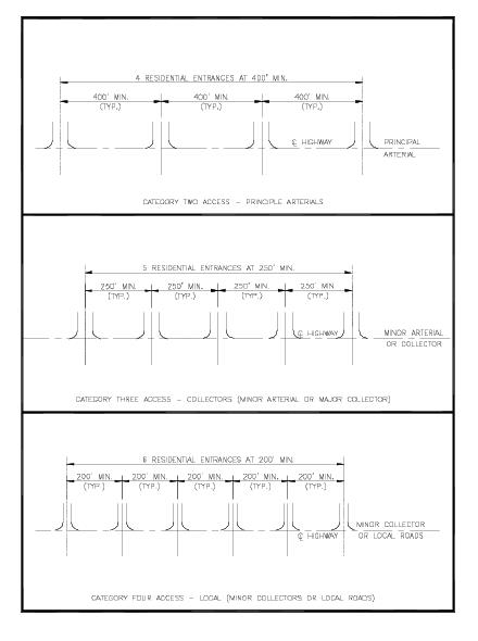
9.3 Category One (Interstate or Toll Road)
9.3.1 Functional Characteristics. These highways have the capacity for high speed and high volume traffic movements over long distances in an efficient and safe manner, including interstate, interregional, intercity and, in larger urban areas, intra-city travel. Federal aid interstate highways are typical of this category.
9.3.2 Design Standards. All opposing traffic movements shall be separated by physical constraints such as grade separations and median separators. Access, consisting of directional ramps, shall be suitably spaced and designed to provide the minimum differential between the speed of the through traffic stream and the speed of the merging or diverging vehicles. Location and design of access shall be determined on an individual basis by DelDOT. Each access allowed to a Category One highway must receive the specific approval of the Chief Engineer and the FHWA. Access to interstate highways must comply with federal regulations. Temporary access may be allowed during official emergencies or where directly related to a freeway construction project.
9.4 Category Two (Arterials)
9.4.1 Functional Characteristics. These highways have the capacity for high speed and high volume traffic movements in an efficient and safe manner, providing for interstate, interregional, and intercity, travel needs and some intra-city travel needs. Direct access service to abutting land is subordinate to providing service to through traffic movements. Category Two is the highest category that permits at-grade intersections.
9.4.2 Design Standards
The design of Category Two highways should be capable of achieving a posted speed limit of 35 to 45 MPH where signals are present, and 45 to 55 MPH in rural areas. Typical spacing of intersecting streets, roads, and highways shall be planned at intervals of 2,500 feet. A minimum of 1,250 feet spacing should be permitted only when no reasonable alternative access to the street system exists.
Unless otherwise specifically categorized, all overpasses, underpasses, structures, ramps, and roadway sections between frontage roads and the main highway are Category Two.
Private direct access shall not be permitted unless the property retains deeded rights of access and the property has no other reasonable access to the street system.
All private direct access permitted shall be for right turns only unless:
No additional access shall be provided upon the splitting or dividing of existing parcels or contiguous parcels under the same ownership or control. All access to the newly created properties shall be provided internally from the existing access. Any new access determined by the permit application shall be consistent with the requirements of Standards and Regulations for Subdivision Streets and State Highway Access.
All access provided to a Category Two highway shall be done so with the understanding that if the highway is reconstructed to a Category One, alternative access may be provided by a frontage road or other means.
Opposing roadway traffic movements shall be separated by physical constraints such as grade separation or a median separator of sufficient design to physically prevent illegal movements.
Intersections with high traffic volumes should have either grade separations or interchanges.
Traffic signals should be programmed to allow speeds of 35 to 45 MPH. Signals at intersections with major cross streets may be programmed to optimize traffic on both streets equally. The efficiency of the signal system should be analyzed including volume, capacity, and level of service calculations.
9.4.2.1 Signal Spacing Criteria
The standard for the spacing of all intersecting State-maintained roadways and other accesses that are or may become signalized, shall be at 2,500 feet intervals, plus or minus 200 feet. For the purposes of achieving good arterial capacity and efficiency and to minimize delays to the traveling public the desirable bandwidth and efficiency for traffic signal progression is 80 percent and the minimum is 40 percent.
Exceptions to this 2,500 feet standard shall not be considered or permitted unless the proposal documents that there are no other reasonable alternatives to achieve a 2500 feet interval, there is a proven necessity for the intersection, and a study acceptable to DelDOT is completed. Topography and existing conditions may make 2,500 feet intervals inappropriate or not feasible. In that case, location of the access shall be determined with consideration given to topography, property ownership, unique physical limitations, unavoidable or pre-existing land use patterns and physical design constraints. The final location should serve as many properties and interests as possible to reduce the need for additional direct access to the state highway.
9.4.2.2 Signalized Access Study Requirements
9.4.2.2.1 When a study is required, the study shall be completed and signed by a Delaware registered professional engineer using the following standards:
9.4.2.2.1.1 Evaluation of current traffic data and 20-year projections and any key year midpoints assuming development of the study area based upon zoning and comprehensive plans.
9.4.2.2.1.2 Highway signal progression bandwidth and efficiency analysis including current and anticipated future signalized intersections.
9.4.2.2.1.3 An optimum signal cycle as determined by DelDOT.
9.4.2.2.1.4 Actual speeds as determined by a spot speed study.
9.4.2.2.1.5 A highway bandwidth of 40 percent shall be used where conditions allow but no less than 30 percent bandwidth where existing or future locations may be at or below 30 percent.
9.4.2.2.1.6 The green time allowed for the cross street shall be no less than the time necessary to accommodate pedestrian movements.
9.4.2.2.2 The study shall also provide the following information:
9.4.2.2.2.1 Notation of all existing access, possible future access locations for at least one mile in each direction, and all potential roadway and signal improvements.
9.4.2.2.2.2 Current and future arterial travel speed, travel time, and delay time.
9.4.2.2.2.3 Traffic generation rate estimates.
9.4.2.2.2.4 Information, data and reference sources.
9.4.2.2.2.5 An evaluation of the level of service for all geometric elements.
9.4.2.2.2.6 Accurate and understandable diagrams.
9.4.2.2.2.7 All assumptions and adjustment factors.
9.4.2.2.2.8 An analysis of all reasonable alternatives including a no build alternative.
9.4.2.2.2.9 A safety analysis including conflict points and movements.
9.4.2.2.2.10 A conceptual design showing all geometric elements and approximate dimensions with detailed analysis of any elements below code standards.
9.4.2.2.3 Additional information and additional analysis based upon other factors and standards may be required if determined to be necessary for a complete evaluation.
9.4.2.2.4 Any access that would reduce the optimum highway bandwidth if a traffic signal were installed shall be limited to right turns unless it meets the three numbered requirements of Section 9.4.2.
9.5 Category Three (Collectors)
9.5.1 Functional Characteristics. These highways have the capacity for medium to high travel speeds and high traffic volume over medium and long distances in an efficient and safe manner. They provide connections between arterials and local roads. Direct access service to abutting land is subordinate to providing service to through traffic movement.
9.5.2 Design Standards
The design of all Category Three highways should be capable of achieving a posted speed limit of 35 to 45 MPH on urbanized signalized segments and preferably 50 MPH in rural areas. A speed limit of 35 to 45 MPH in urbanized areas is acceptable where posted and there is little or no possibility of achieving higher speeds.
Private direct access to State-maintained roadways shall not be permitted when the property in question has other reasonable access or reasonable opportunity to obtain other reasonable access to a lower functional roadway. If DelDOT determines that denial of direct access to the State-maintained roadway would cause unacceptable traffic operation or safety problems at the alternative access location(s) and to the overall traffic flow of the roadway system, or the proposed location is consistent with the spacing and public intersection requirements of this Section, direct access may be allowed. When direct access is to be allowed, such access shall continue until such time that some other reasonable access to a lower function category street or highway is available. No more than one such access shall be allowed to an individual parcel or to contiguous parcels under the same ownership. A combined driveway may be construed as a single access.
Where local regulations require a secondary access to provide for emergency services, DelDOT may allow an emergency access. Such an access shall not be open for non-emergency uses and shall be maintained by the permittee as a closed access except during emergencies.
When private direct access to a state-maintained roadway is allowed, it will generally be restricted to right turns only. One or both left turn movements may be permitted if the applicant establishes to DelDOT’s satisfaction that:
A right turn movement may be restricted if, in the determination of DelDOT, the movement creates an operational problem or safety hazard.
Since intersecting public ways may in time warrant signalization, it is required that all intersecting streets, roads and highways, that allow left turns meet the signal spacing criteria under Section 9.4.2.1. Those that do not meet these requirements shall be limited to right turns only, unless they meet the requirements of this Section.
No additional access rights shall accrue upon the splitting or dividing of existing parcels or contiguous parcels under the same ownership or control. All access to the newly created properties shall be provided internally from the existing access. Any new access determined by the permit application shall be consistent with the requirements of Standards and Regulations for Subdivision Streets and State Highway Access.
When an existing access meets the warrants for a traffic signal as defined in the Delaware MUTCD, and the location does not meet the requirements of Section 9.4.2.1, a median separator may be installed or the access designed to direct vehicles into right turns only. These design solutions may not be practicable or feasible where there are physical constraints such as curbs, sidewalks, structures, and lack of rights-of-way. The access may be required to be reconstructed, or relocated to conform to these Standards and Regulations for Subdivision Streets and State Highway Access.
9.5.2.1 Signal Spacing Criteria. The standard for the spacing of all intersecting State-maintained roadways and other accesses that are or may become signalized, shall be in accordance with Section 9.4.2.1.
9.5.2.2 Signalized Access Study Requirements. When a study is required, the study shall be completed and signed by a Delaware registered professional engineer in accordance with Section 9.4.2.2.
9.6 Category Four (Local)
9.6.1 Functional Characteristics. These highways have the capacity for moderate travel speeds and moderate traffic volumes over medium and short travel distances providing for intra-city and intercommunity travel needs. There is a reasonable balance between direct access and mobility needs within this category.
9.6.2 Design Standards
The design of all Category Four highways should be capable of achieving a posted speed limit of 30 to 45 MPH. The posted speed limit shall be used to meet the requirements of access to State-maintained roadways unless an approved plan or study shows improvements to the highway require a higher speed limit be used.
One access may be allowed from a State-maintained roadway to an individual parcel or to contiguous parcels under the same ownership or control where such access will not compromise the safety and operation of the highway. Additional access may be provided (see Section 7.2.3.1).
9.6.2.1 Signal Spacing Criteria. The standard for the spacing of all intersecting State-maintained roadways and other accesses that are or may become signalized, shall be in accordance with Section 9.4.2.1.
9.6.2.2 Signalized Access Study Requirements. When a study is required, the study shall be completed and signed by a Delaware registered professional engineer in accordance with Section 9.4.2.2.
9.7 Category Five (Access)
9.7.1 Functional Characteristics. Category Five shall be assigned only to roadways that are designed as frontage or service roads where there is no intended purpose of providing for long distance or high volume traffic movements. Access needs will take priority over through traffic movements without compromising safety or operation. Providing reasonable and safe access to abutting property is the primary purpose of this access category. At the request of the local land use agency or their designee, DelDOT may change any frontage or service road to a higher category to support local transportation plans.
9.7.2 Design Standards
One direct access may be allowed from a State-maintained roadway to an individual parcel or to contiguous parcels under the same ownership or control where such access will not be detrimental to the safety and operation of the highway.
Additional access may be allowed when DelDOT determines that:
All turning movements, including left turns, may be allowed provided adequate safety and design standards are met.
The existing posted speed limit shall be used in any access permit and design decisions.
9.7.2.1 Signal Spacing Criteria. Minimum spacing between signals shall be that which is necessary for the safe operation and proper design of adjacent accesses. Preference in traffic signal timing and operation shall be given to highways and cross streets of a higher access category or function.
Figure 9.2 Access Category Standards
Functional Classification Roadway Association | Functional Characteristics | Design Standard | Access | Spacing | |
CATEGORY 1 INTERSTATES OR TOLL ROADS | Urban System • Interstate • Freeways or Expressways Rural System • N/A | Have capacity for high-speed high-volume traffic movements over long distances. Travel needs are interstate, interregional, or intercity. Capable of serving larger vehicles carrying all types of goods with heavier loads than permitted on lower class roadways. | All opposing traffic movements shall be separated by physical constraints such as grade separations and median separators. | Limited access to intersecting state maintained roadways under strictly controlled conditions. Temporary access may be allowed during official emergencies or where directly related to a freeway construction project. Location and design of access shall be determined on an individual basis by DelDOT. | Access, consisting of directional ramps, shall be suitably spaced and designed to provide the minimum differential between the speed of the through traffic stream and the speed of the merging or diverging vehicles. |
CATEGORY 2 ARTERIALS | Urban System • Principal Arterial Rural System • Principal Arterial | These highways have the capacity for high speed and high volume traffic movements. Posted speed limit of 35 to 45 MPH where signals are present, and 45 to 55 MPH in rural areas. Travel needs are interstate, interregional, and intercity, travel needs and some intracity travel needs. Category Two is the highest category that permits at-grade intersections. | Intersections with high traffic volumes should have either grade separations or interchanges. Traffic signals should be programmed to allow speeds of 35 to 45 MPH and a desirable bandwidth of at least 50 percent. | Direct access and service to abutting land is subordinate to providing service to through movement. All private direct access permitted shall be for right turns only. Exceptions may be considered. | Typical spacing of intersecting State-maintained roadways shall be planned on intervals of 2,500 feet. A minimum of 1,250 feet spacing may be permitted only when no reasonable alternative access to the street system exists. Spacing of accesses that do not warrant a signal shall comply with the requirements outlined in Figure 9-1. If these minimum requirements cannot be met, then the applicant shall provide a combined access with the adjacent lot. |
CATEGORY 3 COLLECTORS | Urban System • Minor Arterial • Major Collector Rural System • Major Collector | These highways have the capacity for medium to high travel speeds and high traffic volume over medium and long distances in an efficient and safe manner. Travel needs are regional, intercity, and intracity. | Capable of achieving posted speed limit of 35 to 45 MPH on urbanized signalized segments and preferably 50 MPH in rural areas. See signal spacing criteria for detailed discussion associated with traffic signal spacing. | Direct access service to abutting land is subordinate to providing service to through traffic movement. Private direct access to the state highway system shall not be permitted unless DelDOT determines its necessity. When it is allowed, it will generally be restricted to right turns only. Where local regulations require a secondary access to provide for emergency services, DelDOT may allow an emergency access. | The standard for the spacing of all intersecting State-maintained roadways and other accesses that are or may become signalized, shall be at 2,500 feet intervals, plus or minus 200 feet. DelDOT may consider exceptions to this spacing, provided an Access Study is performed (see 9.4.2.2 Access Study Requirements). Spacing of accesses that do not warrant a signal shall comply with the requirements outlined in Figure 9-1. If these minimum requirements cannot be met, then the applicant shall provide a combined access with the adjacent lot. |
CATEGORY 4 LOCAL | Urban System • Local Rural System • Minor Collector • Local | These highways have the capacity for moderate travel speeds and moderate traffic volumes. Travel is short and movement is to intersecting roadways, usually of the collector classification. Travel needs are intracity and intercommunity travel needs. | Capable of achieving posted speed limit of 30 to 45 MPH. The posted speed limit shall be used to meet the requirements of access to State-maintained roadways unless an approved plan or study shows improvements to the highway require a higher speed limit be used. | One access may be allowed from a State-maintained roadway to an individual parcel or to contiguous parcels under the same ownership. Additional access may be provided. | The standard for the spacing of all intersecting State-maintained roadways and other accesses that are or may become signalized, shall be at 2500 feet intervals, plus or minus approximately 200 feet. DelDOT may consider exceptions to this spacing, provided an Access Study is performed (see 9.4.2.2 Access Study Requirements). Spacing of accesses that do not warrant a signal shall comply with the requirements outlined in Figure 9-1. If these minimum requirements cannot be met, then the applicant shall provide a combined access with the adjacent lot. |
CATEGORY 5 ACCESS | Urban System • N/A Rural System • N/A | Access to frontage or service roads. There is no intended purpose of providing for long distance or high volume traffic movements. | The existing posted speed limit shall be used in any access permit and design decisions. All turning movements including left turns may be allowed. Minimum spacing between signals shall be that which is necessary for the safe operation and proper design of adjacent accesses. | Access needs will take priority over through traffic movements. One direct access may be allowed from a State-maintained roadway to an individual parcel or to contiguous parcels under the same ownership or control where such access will not be detrimental to the safety and operation of the highway. | No limit on spacing. |
List of Appendices
APPENDIX (Click on the letter to view the document | |
Manual Updates | |
Improvements Requiring New Rights-of-way | |
Review Fee Application And Calculation Forms | |
Plan Review Checklists | |
Commercial Site Applications And Forms | |
Subdivision Site Applications And Forms | |
Industrial Site Applications And Forms | |
Public Road Construction Applications And Forms | |
Traffic Signal Agreement | |
General Notes For Construction Plans | |
Functional Classification | |
Deldot Transportation Noise Policy | |
Clean Air Act Exemptions | |
List Of Approved Trees | |
Scoping Meeting | |
Critical Movement Summation (Cms) How-to Guide | |
Requirements For Submitting Subdivision Plans To Bridge Design For Review | |
Traffic Impact Study Flowchart |