
department of state
Division of Professional Regulation
2700 Board of Professional Land Surveyors
FINAL
ORDER
2700 Board of Professional Land Surveyors
After due notice in the Register of Regulations and two Delaware newspapers, a public hearing was held on April 17, 2008 at a scheduled meeting of the Delaware Board of Professional Land Surveyors ("the Board") to receive comments regarding proposed amendments to the Board's Rules and Regulations. The proposed Rules and Regulations were published in the Register of Regulations, Vol. 11, Issue 9, on March 1, 2008.
Background
The Board has proposed a number of changes to its Rules and Regulations.
First, Regulation 1.0 is amended to clarify the titles and roles of the Board officers. With respect to Regulation 2.0, language pertaining "field experience" and "direct supervision" is re-written for greater clarity. Regulation 8.0 is stricken and replaced with the requirements for licensure of an applicant holding a degree from a program outside of the United States.
There are several amendments to the Regulations pertaining to continuing education. Language is stricken from Regulation 10.3.2 to clarify that courses must be taught by qualified instructors who are able to interact with the students. With respect to Regulation 10.4.2, language pertaining to a licensee's request for carryover professional development hours is stricken. Regulation 10.8 is amended to state that submissions in response to an audit must be signed and sealed with a Board approved seal. A sanction for noncompliance with continuing education requirements is added to Regulation 10.9: "The minimum penalty for unjustified noncompliance shall be a letter of reprimand and a $250.00 fine."
The Board has proposed a number of changes to Regulation 12.2 pertaining to procedures and standards. Several provisions are re-written for greater clarity. In addition, an amendment to Regulation 12.2 specifies that a plat shall be prepared when a surveyor conducts an ALTA/ACSM Land Title Survey or a Subdivision Survey. Regulation 12.2.2 is amended to state that a plat shall indicate the source of title, tax parcel number and postal address, where applicable. Regulation 12.2.3 is amended to add a statement that bearings shall be written in a clockwise direction on the plat, unless impractical. An amendment to Regulation 12.2.4 adds "firm name" to the methods whereby a monument shall be identified. Regulations 12.2.8 and 12.2.16.3 are amended to state that length and direction shall be indicated in a clockwise direction, unless impractical.
A specific reference to "Attachment A" is added to Regulation 12.4, pertaining to classification of surveys.
There are several changes to the Regulations concerning mortgage inspection plans ("MIPs"). Regulation 11.2 is re-numbered and a sentence is added stating that, for mortgage and deed-related surveys in Kent and Sussex Counties, the minimum requirement is an improvement location drawing, prepared in compliance with
Regulation 12.0. In addition, Regulations are added pertaining to the electronic transmittal of documents.
An amendment to Regulation 13.2.5, pertaining to the Code of Ethics, states that a surveyor shall not permit the use of his or her professional seal on any work for which he or she did not have direct supervision. With respect to Regulation 16.0, concerning renewal of lapsed licenses, the following sentence is stricken: "A licensee who does not file for renewal within that period must re-apply for a new license."
Finally, Attachment B, addressing evaluation of applicant credentials, is stricken in its entirety.
The Board's authority to promulgate Rules and Regulations implementing or clarifying specific sections of Chapter 27 is set forth in 24 Del.C. §2706(a)(l). The proposed amendments specifically identify changes related to the practice of professional land surveyors.
Summary of the Evidence and Information Submitted
Michael Paraskewich and James Bielicki, of the Pelsa Company, submitted to the Board a letter regarding the amended Regulation 12.12. They stated their view that consumers in Kent and Sussex Counties should be given the option of having a mortgage inspection plan done. They noted that consumers in New Castle County, and in Maryland, New Jersey and Pennsylvania, are given this option.
At the April 17, 2008 hearing, there was discussion pertaining to a number of the proposed amendments. There was a suggestion of adding "the hundred and county" to the revision to Regulation 12.2.2. There was discussion as to whether it was appropriate to strike the last sentence of Regulation 16.0, addressing the renewal of lapsed licenses.
There was also discussion regarding Regulation 12.2, with respect to monumentation of minor subdivision plans.
It was suggested that the Board address, at a later time, a possible grandfather clause to Regulation 18.4, pertaining to professional seals.
Finally, amended Regulation 12.12 was addressed. Mr. Brad Temple stated that, as set forth in Regulation 12.12, for mortgage and deed related surveys, minimum local standards in Kent and Sussex Counties require an improvement location drawing. Mr. Charles Adams also stated that minimum local standards in Kent and Sussex Counties require an improvement location drawing.
While there was extensive discussion at the hearing regarding a variety of issues, after deliberation, the Board decided to address any other changes to the Rules and Regulations at a later time and to approve the proposed amendments as published.
Findings of Fact with Respect to the Evidence and Information Submitted
The Board carefully reviewed and considered the proposed Rules and Regulations and the evidence and information submitted.
The Board finds that adopting the amended Rules and Regulations as proposed is in the best interest of the citizens of the State of Delaware and is necessary to protect the health and safety of the general public.
Decision and Effective Date
The Board hereby adopts the changes to the Rules and Regulations to be effective 10 days following publication of this order in the Register of Regulations.
Text and Citation
The text of the revised Rules and Regulations remains as published in the Register of Regulations, Vol. 11, Issue 9, March 1, 2008.
SO ORDERED this 15th day of May, 2008.
BOARD OF PROFESSIONAL LAND SURVEYORS
|
Michael T. Szymanski, PLS, Chairman
|
|
R. McBride, PLS, Vice-Chairman
|
|
Stephen M. Sellers, PLS, Secretary
|
|
Victor Kennedy, Public Member
|
|
Frank Szcucka, Public Member
|
2700 Board of Professional Land Surveyors
1.1 Pursuant to 24 Del.C. Ch. 27, the Delaware Board of Professional Land Surveyors ("the Board") is authorized to, and has adopted, these Rules and Regulations. The Rules and Regulations are applicable to all Professional Land Surveyors and applicants to the Board.
1.2 Information about the Board, including its meeting dates, may be obtained by contacting the Board's Administrative Assistant at the Division of Professional Regulation. Requests to the Board may be directed to the same office or visit our web site at www.dpr.delaware.gov.
1.3 The Board's President Chair shall preside at all meetings of the Board and shall sign all official documents of the Board. In the President's Chair’s absence, the Board's Secretary Vice Chairman shall preside at meetings and perform the duties usually performed by the President Chair.
1.4 The Board may seek counsel, advice and information from other governmental agencies and such other groups as it deems appropriate.
1.5 The Board may establish such subcommittees as it determines appropriate for the fair and efficient processing of the Board's duties.
1.6 The Board reserves the right to grant exceptions to the requirements of the Rules and Regulations upon a showing of good cause by the party requesting such exception, provided that the exception is not inconsistent with the requirements of 24 Del.C. Ch. 27.
1.7 Board members are subject to the provisions applying to "honorary state officials" in the "State Employees', Officers' and Officials' Code of Conduct," found at 29 Del.C. Ch. 58.
Definitions under Section 2 will be listed in the current "Definitions of Surveying and Associated Terms," published by the American Congress on Surveying and Mapping, except as otherwise provided by Delaware law.
“Combined Office and Field Experience” - is defined as being multi-faceted experience in responsible charge of land surveying projects, performed under the direct supervision of a professional land surveyor in the active practice of land surveying. The office aspect of this experience shall include the technology relevant to civil drafting, mathematical calculations necessary for subdivision, boundary and right-of-way determinations, road, design, stormwater, sediment and erosion control, and sewer design as well as the interpolation of field-run topographical data and the like. Office experience should also include applied familiarity with land development submittal and approval processes.
The subject field experience shall include time spent in responsible charge relevant to all aspects of on-site inspection, evaluation and field-gathered information as well as the supervision of crew personnel and communication and coordination with a professional land surveyor and office staff.
Field experience shall include time spent on site in responsible charge of inspection, evaluation, and gathering of relevant survey information. On-site supervision of and responsibility for field crew personnel while in communication and coordination with a professional land surveyor and office staff shall qualify as field experience.
“Direct Supervision” - applies to one duly licensed as a Professional Land Surveyor (PLS) and only a licensee may provide direct supervision. The physical presence of a PLS on every type of surveying project is not required. There are, however, times when a site visit is necessary to make important decisions involving boundary retracements, property line disputes, etc.
Direct supervision of a party chief and field crew would personnel requires daily contact to determine the need for the presence of a PLS on site. This need would be based upon the type of work to be performed and the professional judgment of the PLS in charge. Should it be determined that a site visit is not warranted, the PLS, at a minimum, should instruct the field crew personnel as to the procedures to be used, the data to be gathered, the maps or plats to be relied upon and the scope of the work to be performed. At the end of the assignment, all work should be reviewed and checked by the PLS. The PLS shall follow the same minimum requirements when instructing survey office personnel. All assignments performed by survey personnel, both field and office, shall be reviewed and checked by the PLS providing direct supervision.
While it has been argued that a survey crew does not always have to be under the direct supervision of a PLS, it is the Board's opinion that only a PLS has the ability to make that determination. It is therefore necessary for the field crew to have daily contact with the PLS so that this decision can be made properly, in order to protect the public.
“Related Science Curriculum” – are those courses of study for which one-third of the required core courses are the same or similar as those required for a Baccalaureate Degree Program in Surveying. These core courses may include but are not limited to Algebra, Trigonometry, Analytical Geometry, Calculus, General Physics and Computer Programming.
Degrees in related fields of study may include but not be limited to Civil Engineering, Mathematics, Physics, Agricultural Engineering, Actuarial Studies, Statistics, Geology and Forestry.
Because requirements for graduation differ from institution to institution, when considering these Related Science Curriculums attention will be given to the specific coursework completed. This examination of completed coursework may allow for greater flexibility of this definition. Section 2708(a).
“Surveying Curriculum” – For the purpose of these regulations, the term "Surveying Curriculum" will mean any approved curriculum for a Baccalaureate Degree in Surveying as it is accepted by the institution bestowing the said degree. This curriculum shall necessarily include but not be limited to courses in Surveying, Advanced Surveying, Legal Principles of Surveying, Data Adjustment, Subdivision Planning and Layout, Route and Construction Surveying, Engineering and Geodetic Astronomy, Topographic Surveying and Cartography and/or those other studies required by the institution where the degree is earned.
Independent study course work (which includes all correspondence, internet and distance-learning study) shall be considered only if those courses have been accepted by an Accreditation Board for Engineering and Technology (ABET) as part of the approved curriculum. Section 2708(a).
The Board shall meet at least once each quarter of the calendar year. At the first regularly scheduled meeting in the first quarter, the Board will elect from its members a chair, vice-chair, and secretary. Section 2704(b).
The Application Form for those seeking licensure under 24 Del.C. Ch. 27 shall be reviewed every five years. Section 2706 (a)(2).
For the required National Examination for licensure under 24 Del.C. Ch. 27, the Board adopts the two-part examination developed by the National Council of Examiners for Engineering and Surveying (NCEES), consisting of the Principles and Practice of Surveying Examination and the Fundamentals of Surveying Examination, as amended from time to time (then in effect at time of examination). Section 2706(a)(3).
6.1 For the required drainage examination/Delaware law examination the Board adopts the bank of questions developed for this purpose and/or approved for this purpose by a recognized psychometrician or other authority whose services are acquired and approved by the Division of Professional Regulation of the Delaware Department of State. Section 2706(a)(4).
6.2 Exam review procedures.
6.2.1 An applicant may review only the questions answered incorrectly.
6.2.2 No other materials will be allowed into the room when reviewing the exam.
6.2.3 There will be a 30-minute time limit supervised by the Division of Professional Regulation.
6.2.4 The fee will be determined by the Division of Professional Regulation.
6.2.5 An applicant cannot review the exam within 90 days prior to the next exam date.
6.2.6 An exam review will be limited to only one review.
The Board adopts the administration and grading procedures and the passing scores adopted by the NCEES for the two-part national examination, described in Section 5.0 of these regulations. Section 2706(a)(5).
See Attachment B.
8.1 Any applicant holding a degree from a program outside the United States or its territories must provide the Board with an educational credential evaluation from The Center of the National Council of Examiners of Engineers and Surveyors, its successor, or any other similar agency approved by the Board, demonstrating that their training and degree are equivalent to domestic accredited programs. No application is considered complete until the educational credential evaluation is received by the Board.
8.2 Applications will be kept active and on file for two (2) years. If the applicant fails to meet the licensure requirements and/or pass the examination within two (2) years, the application shall be deemed to have expired and the applicant must reapply in the same manner as for initial application, i.e., submits the application, documentation, proper fee, and obtains board approval to be eligible to sit for the examination.
8.3 The Board will not review incomplete applications.
8.4 All signatures must be original on all forms.
8.5 The applicant shall have obtained the passing score on the NCEES Fundamentals of Surveying, NCEES Principles of Surveying and DE State Drainage and Law Examination.
9.1 When an applicant is approved for licensure, the Division of Professional Regulation will send a letter to the applicant advising that person of the prorated license fee. Once the license fee is received by the Division, a license number is issued and mailed to the applicant.
9.2 The Division of Professional Regulation will send a renewal notice to the last known address for each licensee at least 30 days prior to renewal. Even if a licensee does not receive a renewal, it is his/her responsibility to renew their license.
10.1 Biennium Requirements.
Effective each biennium, as a condition for renewal of a Certificate of Registration license for the practice of land surveying, a Professional Land Surveyor shall be required to successfully complete 24 hours of professional development within the preceding biennium. Any licensee who completes in excess of 24 hours of professional development within the preceding biennium may NOT have the excess applied to the requirements for the next biennium.
10.2 A licensee shall complete at least two (2) hours on ethics and professionalism for each renewal period with no carry-over credit for any biennium renewal period.
10.3 Sources of Credit. In reviewing and approving applications for PDHs, the Board shall take into consideration:
10.3.1 Program Content: Courses must cover land surveying topics and must directly contribute to accomplishment of the primary purpose of continuing education, which is to help assure that licensees possess the knowledge, skills and competence necessary to function in a manner that protects and serves the public interest. The knowledge or skills taught must enable licensees to better serve surveying clients and the subject matter must be directly related to the land surveying practice. All educational courses must be approved by the Board.
10.3.2 Instruction: Except as set forth below, tThe course must be one that will be conducted by a qualified instructor who will be able to interact directly either in person or by interactive television with all students at all times during the course. The course may be conducted through the use of interactive television or other media which permits continuous mutual communication between the instructor and all students, continuous observation of the instructor by all students, and continuous observation of all students by the instructor. Distance education courses may be acceptable when the sponsor gives the licensee a final exam and sends verification to the Board that the licensee has completed the course with a passing grade.
10.3.2.1 Distance education courses are defined as programs whereby instruction does not take place in a traditional classroom setting but rather through other media where teacher and student are apart. Distance education may not be utilized with the exceptions of interactive television and verified courses described above.
10.3.3 Examples of topics that are acceptable, but not limited to:
ALTA/ACSM land title surveys
GPS (survey related)
GIS (survey related)
Delaware land use laws
Case law
Boundary laws and regulations
Research
Evidence
Boundary determination
Unwritten rights
Conflict resolution; i.e. boundary line agreements
Adverse possession
Highway surveys
Railroad surveys
Easements and rights of way
Geodesy
Highway design/Highway safety
Surveyor in court/Expert testimony
State and international boundaries
Water boundaries
Technical writing related to deed descriptions and survey
reports
Mathematics and computer applications of land surveying
Measurement and analysis
Photogrammetry and aerial photo interpretation
Survey standards
Survey instrumentation
Business management and professional development related
to the land surveying practice; i.e. surveying contracts,
communicating with clients, good business planning
and management, quality assurance
Ethics and professionalism
Liability for land surveyors
Drainage design
Sediment and erosion control
First aid/CPR
10.3.4 Serving as a member of a committee or a board or a commission, which has as its primary duty the preparation or grading of written tests which are given for the purpose of determining the proficiency of an applicant for registration, using accepted test development principles, shall be counted as one (1) PDH per hour of attendance.
10.3.5 Attendance at workshops or seminars, which are directly related to land surveying, shall count as one (1) PDH per actual hour of classroom attendance. Such sessions must be planned in advance, a record must be maintained describing the content and a record of attendance must be kept. This may include society meetings in which educational programs are presented.
10.3.6 The active teaching of land surveying at the college level, within the immediate preceding biennium, shall be counted as eight (8) PDHs per year. No more than sixteen (16) PDHs shall be issued for teaching at the college level in any renewal period. CREDIT WILL NOT BE GIVEN TO FULL TIME EDUCATORS.
10.3.7 Teaching a workshop or seminar, which is directly related to land surveying or professional development, shall be counted as two (2) PDHs per actual hour of teaching time, not to include preparation. No more than eighteen (18) PDHs may be claimed in any 2-year period. CREDIT WILL BE GIVEN FOR ONLY ONE PRESENTATION IN A TWO-YEAR PERIOD.
10.3.8 College level courses directly related to land surveying or professional development shall be counted as 40 PDH per credit hour. Ten (10) PDHs will be counted for each CEU (continuing education unit) earned.
10.3.9 Presentation and/or publication of a professional paper will be counted as 10 PDHs. No more than 20 PDHs may be claimed in any biennium renewal.
10.4 Renewal Credit.
10.4.1 Each licensee applying for renewal shall attest to satisfying the continuing education requirements outlined in Rule 10.1, 10.2, and 10.3 in the period defined in Section 10.1 of these rules. Attestation may be completed electronically if the renewal is accomplished online. In the alternative, paper renewal documents that contain the attestation of completion can be submitted.
10.4.2 If the Board should, for any reason, deny or modify the licensee's request for carryover PDHs, the Board shall notify the licensee of such action after the next Board meeting. The licensee's submittal shall be on a form provided by the Board and shall contain a statement signed and sealed by the licensee, which attests to the correctness thereof. Such statement shall accompany and be filed with the licensee's request for renewal. Licensees should retain their PDH files and records for at least five (5) years.
10.5 Pro-Rated Credits for Renewal. A licensee for renewal shall follow the following schedule of reporting PDH credits: if, at the time of renewal, you have been licensed for less than one year, NO continuing education is required; licensed for more than one year, but less than two years, half (12 PDHs) is required; licensed for two or more years, the full amount (24 PDHs) is required.
10.6 Renewal. Any licensee who has submitted a correctly completed paper or electronic renewal form as required in Section 10.4.1 and has met all other requirements shall be granted renewal.
10.7 Audit. Each biennium, the Division of Professional Regulation shall select from the list of potential renewal licensees a percentage, determined by the Board, which shall be selected by random method. The Board may also audit based on complaints or charges against an individual license, relative to compliance with continuing education requirements.
10.8 Documentation and Audit by the Board. When a licensee whose name or number appears on the audit list applies for renewal, the Board shall obtain documentation from the licensee showing detailed accounting of the various PDHs claimed by the licensee. Licensees selected for random audit are required to supplement the attestation with attendance verification. The Board shall attempt to verify the PDHs shown on the documentation provided by the licensee. The Board shall then review the documentation and verification. Upon completion of the review, the Board shall decide whether the licensee's PDHs meet the requirements of these rules and regulations. The licensee shall sign and seal all verification documentation with a Board approved seal.
10.9 Board Review. The Board shall review all documentation requested of any licensee shown on the audit list. If the Board determines the licensee has met the requirements, the licensee's certificate of registration shall remain in effect. If the Board initially determines the licensee has not met the requirements, the licensee shall be notified and a hearing may be held pursuant to the Administrative Procedures Act. This hearing will be conducted to determine if there are any extenuating circumstances justifying the apparent noncompliance with these requirements. Unjustified noncompliance of these regulations shall be considered misconduct in the practice of land surveying, pursuant to 24 Del.C. §2712. The minimum penalty for unjustified noncompliance shall be a letter of reprimand and a $250.00 fine.
10.10 Noncompliance – Extenuating Circumstances. A licensee applying for renewal may request an extension and be given up to an additional twelve (12) months to make up all outstanding required PDHs providing he/she can show good cause why he/she was unable to comply with such requirements at the same time he/she applies for renewal. The licensee must state the reason for such extension along with whatever documentation he/she feels is relevant. The Board shall consider requests such as extensive travel outside the United States, military service, extended illness of the licensee or his/her immediate family, or a death in the immediate family of the licensee. The written request for extension must accompany the renewal application. The Board shall issue an extension when it determines that one or more of these criteria have been met or if circumstances beyond the control of the licensee have rendered it impossible for the licensee to obtain the required PDHs. A licensee who has successfully applied for an extension under this paragraph shall make up all outstanding hours of professional development within the extension period approved by the Board.
10.11 Appeal. Any licensee denied renewal pursuant to these rules and regulations may contest such ruling by filing an appeal pursuant to the Administrative Procedures Act.
10.12 Retired Licensees. Licensees 62 years old and over who are retired (working less than 20 hours weekly) shall need only twelve (12) PDHs, including one ethics PDH, each biennium to satisfy the professional development requirements outlined herein.
10.13 Multiple State Licensees. Any licensee, who is not a Delaware resident and resides in another state or commonwealth, and is licensed in that state or commonwealth having a comparable continuing education requirement, shall not be required to satisfy these requirements in addition to those of his/her home state, but will satisfy these requirements as a minimum. Any questions regarding compliance with this Section shall be resolved by the Board.
Upon notice to the Board that a disciplinary investigation of a licensee is underway by the Division of Professional Regulation, the Board shall designate a Board member to assist the investigator. Whenever feasible, the Board member designated for this purpose should not reside in the county where the licensee under investigation resides or maintains his or her dominant area of practice. Section 2706(a)(10).
12.1 The Board is required under Sections 2701 and 2112(a)(9) to establish minimum technical standards for licensees. The purpose of these standards is to establish minimum technical criteria to govern the performance of surveys when more stringent specifications are not required by other agencies or by contract. Further, the purpose is to protect the inhabitants of this state and generally to promote the public welfare. The Board also established minimum standards for Mortgage Inspection Plans (MIPs), and other types of work, frequently performed by licensees in portions of the state.
12.2 Procedure and Standards. Whenever a surveyor conducts a boundary survey, or an improvement location survey of properties, or an ALTA/ACSM Land Title Survey, or Subdivision Survey, a plat showing the results shall be prepared. and a A copy of the survey shall be furnished to the client unless deemed unnecessary by the client. The plat shall conform to the following requirements and shall include the following information:
12.2.1 The plat shall be drawn on any reasonably stable and durable drawing paper, vellum or film of reproducible quality. No plat or map shall have dimensions of less than 8 ½ x 11 inches.
12.2.2 The plat shall indicate the Source of Title, Tax Parcel Number and, when applicable, the Postal Address of the subject property. The plat shall show the written scale, area and classifications of the survey. These classifications (suburban, urban, rural, and marshland) are based upon both the purposes for which the property is being used at the time the survey is performed and any proposed developments, which are disclosed by the client, in writing. This classification must be based on the criteria in Section 12.4 and the survey must meet the minimum specifications set forth in Attachment A. The scale shall be sufficient to show detail for the appropriate classification.
12.2.3 The horizontal direction of all boundary lines shall be shown in relationship to grid north, magnetic, or in lieu thereof, to true north or to such other established line or lines to which the survey is referenced. The horizontal direction of the boundary lines shall be by direct angles or bearings. A prominent north arrow shall be drawn on every sheet. The description of the bearing reference system shall be stated on the plat. Bearings shall be written in a clockwise direction unless impractical.
12.2.4 All monuments, natural and artificial (man-made), found or set, used in the survey, shall be shown and described on the survey plat. The monuments shall be noted as found or set. All monuments set shall be ferrous metal, or contain ferrous metal, not less than ½ inch in diameter and not less than 18 inches in length, except however, a corner which falls upon solid rock, concrete, or other like materials shall be marked in a permanent manner and clearly identified on the plat. Monuments shall be set at all corners of all surveys as required by these standards, with the exception of meanders such as meanders of streams, tidelands, wetlands, lakes, swamps and prescriptive road rights-of-way. Witness monuments shall be set or referenced whenever a corner monument cannot be set or is likely to be disturbed. Such witness monument shall be set as close as practical to the true corner. If only one (1) witness monument is set, it must be set on the actual boundary line or prolongation thereof. Otherwise, at least two (2) witness monuments shall be set and so noted on the plat of the survey. Monuments shall be identified, where possible, with a durable marker bearing the firm name or the surveyor's registration number and/or name.
12.2.5 The plat of a metes and boundary survey must clearly describe the commencing point and label the point of beginning for the survey.
12.2.6 Notable discrepancies between the survey and the recorded description, shall be noted. and tThe source of information title used in making the survey, shall be indicated. When an inconsistency is found, including a gap or overlap, excess or deficiency, erroneously located boundary lines or monuments, the nature of the inconsistency shall be indicated on the drawing.
12.2.7 In the judgment of the surveyor, the description and location of any physical evidence found along a boundary line, including but not limited to fences, walls, buildings or monuments, shall be shown on the drawing.
12.2.8 The horizontal length (distance) and direction (bearing) of each line as determined in an actual survey process shall be shown on the drawing and indicated in a clockwise direction unless impractical.
12.2.9 At least three (3) elements (including The radius, arc length, and chord bearing and chord distance) of all circular curves, shall be shown.
12.2.10 Information used by the surveyor in the property description shall be clearly shown on the plat, including but not limited to, the point of beginning, course bearing, distance, monuments, etc.
12.2.11 The lot and block or tract numbers or other recorded subdivision designations, including those of adjoining lots, if the survey is within a recorded subdivision of the subject property and adjoining properties shall be shown. If the adjoining propertyies is are not within a recorded subdivision, then the name and deed record of all adjoining owners shall be shown.
12.2.12 Recorded public and private rights-of-way or easements which are discovered during the title search performed by others and supplied to the surveyor or graphically shown on the recorded plat, which includes the property, or which are known or observed adjoining or crossing the land surveyed, shall be shown.
12.2.13 Location of all permanent improvements pertinent to the survey, referenced radially and perpendicular to the nearest boundary, shall be shown.
12.2.14 Visible or suspected encroachments onto or from adjoining property or abutting streets, with the extent of such encroachments, shall be shown.
12.2.15 A plat or survey shall clearly bear the Company Firm Name and individual licensee’s name, license number, title, “Professional Land Surveyor”, [contract contact] address, and date of survey and original signature and board-approved seal of the licensed surveyor in responsible charge. This signature and seal is certification that the survey meets minimum requirements of the Standards for Land Surveyors as adopted by the Delaware Board.
12.2.16 The following information shown on the plat must be included in a written description, if one is provided:
12.2.16.1 The commencing point and point of beginning.
12.2.16.2 Sufficient caption to connect the plat and description.
12.2.16.3 Length and direction of all lines in a clockwise direction unless impractical.
12.2.16.4 Curve information as described in paragraph 12.2.9.
12.2.16.5 Type of monuments noted as found or set.
12.2.16.6 The area of the parcel.
12.2.16.7 Adjoining owners, subdivision name, etc.
12.3 Standards for Horizontal Control.
12.3.1 Definitions for specific types of horizontal control surveys, along with standards and procedures, may be found in National Geodetic Survey (NGS) or successor publications. All geodetic surveys, including determination and publication of horizontal and vertical values utilizing Global Positioning Systems, Ground Control Systems or any other system which relates to the practice and profession of Land Surveying, shall be performed under the direct control and personal supervision of a licensed Professional Land Surveyor licensed in the State of Delaware.
12.3.2 Control Surveys that are used to determine boundary lines, including developing coordinates for existing boundary corners, shall meet the Standards contained herein.
12.3.3 Land Information Systems/Geographic Information Systems (LIS/GIS) maps should be built on a foundation of coordinates obtained by an accurate survey. Creation of LIS/GIS maps and services should include a Professional Land Surveyor licensed in the State of Delaware for coordination and input of their knowledge in these fields.
12.4 Classification of Surveys. (See Attachment A)
12.4.1 Urban Surveys - Surveys of land lying within or adjoining a city or town. This would also include the surveys of commercial and industrial properties, condominiums, townhouses, apartments and other high-density developments regardless of geographic location.
12.4.2 Suburban Surveys - Surveys of land lying outside urban areas. This land is used almost exclusively for single family residential use or residential subdivisions.
12.4.3 Rural Surveys - Surveys of land such as farms and other undeveloped land outside the suburban areas which may have a potential for future development.
12.4.4 Marshland Surveys - Surveys of land which normally lie in remote areas with difficult terrain and usually have limited potential for development and cannot be classified as urban, suburban or rural surveys. This includes, but is not limited to, surveys of farmlands and rural areas.
12.5 ALTA/ACSM Land Title Survey. The current published standard as amended from time to time.
12.6 Mortgage Inspection Plans (MIP)
12.6.1 Purpose. The purpose of an MIP is to locate, describe and represent the positions of buildings or other visible improvements, or both, affecting the property being inspected.
12.6.2 Product. The results of the MIP shall be stated on a plat showing the property inspected and the location of the buildings or other visible improvements affecting the inspected property.
12.7 The Approval by the Consumer and Disclosures.
12.7.1 The surveyor shall not begin work for compensation pursuant to this regulation until the surveyor receives a signed approval form more particularly described below.
12.7.2 The approval form or its equivalent shall be sufficient if signed by one consumer, whether or not there are multiple consumers, or, if a consumer is not an individual, the consumer's duly authorized agent, with respect to the property for which services pursuant to this regulation are sought. The approval form shall at a minimum contain:
12.7.2.1 An approval by the signer of the requested services; and
12.7.2.2 An explanation of the differences between an MIP and a boundary survey which includes an improvement location drawing.
12.7.2.3 The following approval form or its equivalent shall suffice for the purpose of complying with this regulation: "Approval Form (on company letterhead, with name, address and telephone number)
In connection with the purchase or refinancing of the property located at ________________, we have been requested to prepare an MIP.
Since an MIP is not a boundary survey and does not identify property boundary lines, State regulations require us to have your approval. Therefore, please sign and return the original of this form promptly, by fax or mail, so that there will be no delay in settlement.
If you wish, we can perform a boundary survey, which includes an Improvement Location Drawing (ILD). This survey will identify property boundary lines and will mark property boundary corners.
An MIP will cost approximately $______. A boundary survey which includes an ILD will cost (approximately $_________) (between $_____ and $______).
Very truly yours,
Check appropriate lines:
_________We approve the preparation of an MIP. We have read and understand that, in the absence of any problem revealed by or during the preparation of this drawing, it may be all that is required of the land surveyor.
__________We request a boundary survey that will include an ILD, and will identify property boundary lines and mark property boundary corners.
__________________(Signature)
__________________(Signature)
12.7.3 Upon receipt of an approval form, which complies with this section, the surveyor shall perform the services approved by the consumer. If the consumer requests a boundary survey which includes an ILD, then the survey shall be consistent with the provisions set forth in The Minimum Model Standards adopted by the Board.
12.8 Minimum Procedures. If the consumer approves the preparation of an MIP, the surveyor shall perform at least the following procedures:
12.8.1 Examine the current deed and/or plat for the subject parcel and review the most current tax assessment map for inconsistencies with deed or plat.
12.8.2 Take sufficient on-site measurements to enable the surveyor to perform the tasks called for by this regulation with regard to the:
12.8.2.1 Locations of buildings and those other improvements pertinent to the MIP;
12.8.2.2 Locations of possible encroachments reasonably determined based on a visual inspection;
12.8.2.3 Easements; and
12.8.2.4 Rights-of-way.
12.8.3 If the consumer has approved an MIP, then the following elements shall be shown:
12.8.3.1 Significant buildings, structures and other improvements, and their relationship to the apparent property lines referenced radially and/or perpendicular to the nearest boundary, based on the field measurements taken by the surveyor, and any other evidence considered by the surveyor;
12.8.3.2 Statement with regard to the level of accuracy and accuracy of apparent setback distances; (REFER TO ATTACHMENT A)
12.8.3.3 Possible encroachments to the extent reasonably determined by a visual inspection of the property either way across property lines; and
12.8.3.4 Minimum setback lines, as shown on plats,
12.8.3.5 A minimum of two control points and their relationship to each other and the subject property.
12.8.3.6 Easements or rights-of-way as shown on plats or current deed of record for subject property.
12.8.4 If, in connection with the preparation of an MIP, a surveyor finds evidence to warrant, in the surveyor's professional opinion, the performance of a boundary survey, the surveyor shall so notify, in writing, the consumer or the consumer's representative.
12.8.5 If the consumer has approved the preparation of an MIP, then:
12.8.5.1 The MIP prepared by the surveyor shall prominently display, at a minimum, advice to the effect that:
12.8.5.1.1 The MIP is of benefit to a consumer only insofar as it is required by a lender, a title insurance company or its agent in connection with the contemplated transfer, financing, or refinancing; and
12.8.5.1.2 The MIP is not to be relied upon for the establishment or location of fences, garages, buildings or other existing or future improvements.
12.9 Plats.
12.9.1 The original plat of an MIP shall be a reproducible drawing at a scale which clearly shows the results of the field work, computations, research and record information as compiled and checked.
12.9.2 The plat shall be prepared in accordance with the following procedures:
12.9.2.1 A reasonably stable and durable drawing paper, linen or film is considered a suitable material;
12.9.2.2 Plats may not be smaller than 8 ½ x 11 inches;
12.9.2.3 The plat shall show the following:
12.9.2.3.1 Caption or title and address or lot number of the property,
12.9.2.3.2 Scale,
12.9.2.3.3 Date,
12.9.2.3.4 Name and address of the firm or surveyor; and
12.9.2.3.5 Original signature and board-approved seal of the licensed surveyor in responsible charge,
12.9.2.3.6 Consumer's name,
12.9.2.3.7 Statement with regard to the level of accuracy and accuracy of apparent setback distances; (REFER TO ATTACHMENT A)
12.10 Maintenance of Records.
12.10.1 The surveyor shall make a reasonable effort to maintain records, including names or initials of all personnel, date of performance, reference to field data, such as book number, loose leaf pages and other relevant data.
12.11 Local Standards.
12.11.1 All work shall be performed according to the minimum standards for the community in which the service is provided, as long as said standards meet or exceed the standards herein. (1) Current local standards shall take precedence over the MIP as to the manner in which mortgage or deed-related surveys or plans are prepared and as to the manner of field work and staking related to these surveys or plans, if those standards require more detailed or more accurate work to meet those local standards.
12.12 11.2 Based on current information, the MIP shall be accepted as a minimum standard only in New Castle County. In Kent and Sussex counties, MIP’s shall not be considered to meet the minimum local standards for the work required for mortgage or deed-related surveys or plans. For mortgage and deed-related surveys or plans in Kent County and Sussex County, the minimum requirement is an Improvement Location Drawing prepared in compliance with Regulation 12.0 which includes proper monument placement.
12.12.1 Electronically Transmitted Documents. Documents including drawings, specifications and reports, that are transmitted electronically to a client or a governmental agency shall have the computer-generated seal removed from the original file, unless signed with a digital signature as defined in 12.12.2. After removal of the seal the electronic media shall have the following inserted in lieu of the signature and date: This document originally issued and sealed by (Name of sealer), containing the original seal, signature and date of the licensee may be duplicated by photocopy or electronic scanning processes and distributed either in hardcopy or electronic medium. The scanned digital files of properly certified documents are not subject to the requirements of this paragraph. The electronic submission of CAD, vector or other files subject to easy editing are subject to the requirements of this paragraph. Easy editing is based on the file consisting of separate elements that can be individually modified or deleted.
12.12.2 Documents to be electronically transmitted that are signed using a digital signature, shall contain the authentication procedure in a secure mode and a list of the hardware, software and parameters used to prepare the document(s). Secure mode means that the authentication procedure has protective measures to prevent alteration or overriding of the authentication procedure. The term "digital signature" shall be an electronic authentication process that is attached to or logically associated with an electronic document. The digital signature shall be:
12.12.2.1 Unique to the licensee using it;
12.12.2.2 Capable of verification;
12.12.2.3 Under the sole control of the licensee; and
12.12.2.4 Linked to a document in such a manner that the digital signature is invalidated if any data in the document is changed.
12.12.3 Electronic formats must be approved by the board and must meet all criteria set forth in 12.2.1 and 12.2.2.
13.1 Foreword. Honesty, justice and courtesy form a moral philosophy which, associated with mutual interest among men and women, constitutes the foundation of ethics. The surveyor should recognize such a standard, not in a passive observance, but as a set of dynamic principles guiding his/her conduct and way of life. It is his/her duty to practice his/her profession according to this Code of Ethics.
As the keystone of professional conduct is integrity, the surveyor will discharge his/her duties with fidelity to the public, his/her employers and clients, and with fairness and impartiality to all. It is his/her duty to interest his/herself in the public welfare, and to be ready to apply his/her special knowledge for the benefit of mankind. He/she should uphold the honor and dignity of his/her profession and avoid association with any enterprise of questionable character. In his/her dealings with fellow surveyors he/she should be fair and tolerant.
13.2 Professional Life.
13.2.1 The surveyor will cooperate in extending the effectiveness of the surveying profession by interchanging information and experience with other surveyors and students and by contributing to the work of surveying societies and associations, schools and the scientific and surveying press.
13.2.2 It shall be considered unprofessional and inconsistent with honorable and dignified bearing for any surveyor to advertise his/her work in a false or deceptive manner that may mislead the public.
13.2.3 The surveyor will avoid all conduct or practice likely to discredit or do injury to the dignity and honor of his/her profession.
13.2.4 Because superior and distinct knowledge of surveying is essential to the profession, it is imperative for the surveyor to continue his/her education.
13.2.5 The surveyor shall not permit the use of his/her professional seal on any work over which he/she was not in responsible charge and/or direct supervision.
13.3 Relations With The Public.
13.3.1 The surveyor will endeavor to extend public knowledge of surveying and will discourage the spreading of untrue, unfair and exaggerated statements regarding surveying.
13.3.2 He/she will have due regard for the safety of life and health of public and employees who may be affected by the work for which he/she is responsible.
13.3.3 He/she will express an opinion only when it is founded on adequate knowledge and honest conviction while he/she is serving as a witness before a court, commission or other tribunal.
13.4 Relations With Clients and Employers.
13.4.1 The surveyor will act in fairness and in a professional manner toward each client or employer and produce a quality survey regardless of price.
13.4.2 He/she will engage, or advise his/her client or employer to engage, and he/she will cooperate with, other experts and specialists whenever the client's or employer's interests are best served by such service.
13.4.3 He/she will disclose no information concerning the business affairs or technical processes and data of clients or employers without their consent.
13.4.4 He/she will not undertake work which he/she believes will not be successful without first advising his/her client of his/her opinion.
13.4.5 He/she will promptly disclose to his/her client or employer any interest in a business which may compete with or affect the business of his/her client or employer. He/she will not allow an interest in any business to affect his/her decision regarding surveying work for which he/she is employed, or which he/she may be called upon to perform.
13.4.6 An employed surveyor will not solicit or accept other employment to the detriment of his/her regular work or the interests of his/her employer.
13.5 Relations With Surveyors.
13.5.1 The surveyor will see that those licensed to survey are properly qualified by character, ability and training and those who prove unworthy of their privileges are disciplined.
13.5.2 He/she will uphold the principle of appropriate and adequate compensation for those engaged in surveying work, including those in subordinate capacities, as being in the public interest and maintaining the standards of the profession.
13.5.3 He/she will endeavor to provide opportunity for the professional development and advancement of surveyors in his/her employ.
13.5.4 He/she will not directly or indirectly injure the professional reputation, prospects or practice of another surveyor. However, if he/she discovers an error or disagrees with the work of another surveyor, it is the duty of that surveyor to inform the other surveyor of such fact.
13.5.5 He/she will not review the work of another surveyor for the same client, except with the knowledge or consent of such surveyor or unless the connection of such surveyor with the work has been terminated.
13.5.6 He/she will not compete with another surveyor on the basis of charges by reducing his/her normal fees after having been informed of the charges named by the other, or undertake any work at a price that will not permit a satisfactory professional performance. Any offer of professional service should be on the basis of his/her regular fees.
13.5.7 He/she will not use the advantages of a salaried position (public or private) to compete unfairly with another surveyor, or use the advantages of instruments and office facilities (public or private) to compete with other surveyors without charging for such instruments and facilities at current rates.
13.5.8 He/she will not attempt to practice in any field of surveying in which he/she is not proficient. He/she should call in special consulting services to supplement his/her own experience and that of his/her organization on problems outside of their usual field.
Part of the licensure process for applicants under 24 Del.C. Ch. 27 includes a requirement that the applicant not have a criminal conviction record, nor pending criminal charges relating to an offense, the circumstances of which substantially relate to the practice of land surveying. The Board shall review the information provided on the Application Form relating to this issue to determine if the applicant's criminal history record is substantially related to the practice of land surveying. Section 2708(a)(6).
15.1 24 Del.C. §2709 requires the Board to grant reciprocal licenses to applicants presenting proof of current licensure in good standing in another state, the District of Columbia, or territory of the United States, whose standards for licensure are "substantially similar" to Delaware standards.
15.2 All states that are contiguous to Delaware are considered to have "substantially similar" standards to the Delaware standards. In determining whether other jurisdiction's standards are substantially similar, the Board will consider the evidence presented by the applicant intended to show this similarity.
A licensee may renew a license that has lapsed after the renewal date, by payment of the late fee penalty and proof of the required PDHs to the Division of Professional Regulation, if the licensee files for renewal within six (6) months of the most recent renewal date. A licensee who does not file for renewal within that period must re-apply for a new license. Section 2711.
Lost, destroyed, or mutilated licenses may be replaced by payment of the appropriate fee to the Division of Professional Regulation. Section 2716(c).
18.1 A raised seal shall be used wherever possible.
18.2 When a raised seal cannot be used, a rubber seal may be used, but only with red ink so that the lettering will stand out.
18.3 The signature must be originally hand written.
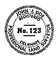
18.4 The seal to be used by a Delaware licensee shall conform to the above regulation and have two concentric circles. The inner circle shall contain only the words "REGISTERED," "NO.," and "DELAWARE." The area between the two circles shall contain, at the bottom, the words "PROFESSIONAL LAND SURVEYOR" reading counterclockwise and at the top, the name of the licensee as written below, reading clockwise.
18.5 The seal acceptable to the Board is the one recognized in the trade as the No. 1 official pocket size, which has an inner circle 1" in diameter and an outer circle 1 ½" in diameter. A sample is below. Replace JOHN DOE AND No. 123 with your name and number.
18.6 All new licensees shall provide to the Board a copy of both the raised and rubber seal within 30 days of issuance of their license.
19.1 Conviction of any of the following crimes, or of the attempt to commit or of a conspiracy to commit or conceal or of solicitation to commit the following crimes, is deemed to be a crime substantially related to the practice of land surveyor in the State of Delaware without regard to the place of conviction:
19.1.1 Menacing. 11 Del.C. §602
19.1.2 Reckless endangering in the second degree. 11 Del.C. §603
19.1.3 Reckless endangering in the first degree. 11 Del.C. §604
19.1.4 Abuse of a pregnant female in the second degree. 11 Del.C. §605
19.1.5 Abuse of a pregnant female in the first degree. 11 Del.C. §606
19.1.6 Assault in the second degree. 11 Del.C. §612
19.1.7 Assault in the first degree. 11 Del.C. §613
19.1.8 Assault by abuse or neglect. 11 Del.C. §615
19.1.9 Terroristic threatening. 11 Del.C. §621(a)(b)
19.1.10 Unlawful administering drugs. 11 Del.C. §625
19.1.11 Unlawful administering controlled substance or counterfeit substance or narcotic drugs. 11 Del.C. §626
19.1.12 Prohibited acts as to substances releasing vapors or fumes. 11 Del.C. §627
19.1.13 Vehicular assault in the second degree. 11 Del.C. §628
19.1.14 Vehicular assault in the first degree.11 Del.C. §629
19.1.15 Vehicular homicide in the second degree. 11 Del.C. §630
19.1.16 Vehicular homicide in the first degree. 11 Del.C. §630A
19.1.17 Criminally negligent homicide. 11 Del.C. §631
19.1.18 Manslaughter. 11 Del.C. §632
19.1.19 Murder by abuse or neglect in the second degree. 11 Del.C. §633
19.1.20 Murder by abuse or neglect in the first degree. 11 Del.C. §634
19.1.21 Murder in the second degree. 11 Del.C. §635
19.1.22 Murder in the first degree. 11 Del.C. §636
19.1.23 Unlawful sexual contact in the second degree. 11 Del.C. §768
19.1.24 Unlawful sexual contact in the first degree. 11 Del.C. §769
19.1.25 Rape in the fourth degree. 11 Del.C. §770
19.1.26 Rape in the third degree. 11 Del.C. §771
19.1.27 Rape in the second degree. 11 Del.C. §772
19.1.28 Rape in the first degree. 11 Del.C. §773
19.1.29 Sexual extortion. 11 Del.C. §776
19.1.30 Continuous sexual abuse of a child. 11 Del.C. §778
19.1.31 Female genital mutilation. 11 Del.C. §780
19.1.32 Unlawful imprisonment in the first degree. 11 Del.C. §782
19.1.33 Kidnapping in the second degree. 11 Del.C. §783
19.1.34 Kidnapping in the first degree. 11 Del.C. §783A
19.1.35 Arson in the first degree. 11 Del.C. §803
19.1.36 Burglary in the third degree. 11 Del.C. §824
19.1.37 Burglary in the second degree. 11 Del.C. §825
19.1.38 Burglary in the first degree. 11 Del.C. §826
19.1.39 Multiple Offenses. 11 Del.C. §827
19.1.40 Possession of burglar’s tools or instruments facilitating theft. 11 Del.C. §828
19.1.41 Robbery in the second degree.11 Del.C. §831
19.1.42 Robbery in the first degree. 11 Del.C. §832
19.1.43 Carjacking in the second degree. 11 Del.C. §835
19.1.44 Carjacking in the first degree. 11 Del.C. §836
19.1.45 Shoplifting. 11 Del.C. § 840
19.1.46 Theft. 11 Del.C. §841
19.1.47 Theft of Services. 11 Del.C. §845
19.1.48 Extortion.11 Del.C. §846
19.1.49 Misapplication of property. 11 Del.C. §848
19.1.50 Theft of rented property. 11 Del.C. §849
19.1.51 Receiving stolen property. 11 Del.C. §851
19.1.52 Identity theft. 11 Del.C. §854
19.1.53 Forgery. 11 Del.C. §861
19.1.54 Falsifying business records. 11 Del.C. §871
19.1.55 Tampering with public records in the second degree. 11 Del.C. §873
19.1.56 Tampering with public records in the first degree. 11 Del.C. §876
19.1.57 Offering a false instrument for filing. 11 Del.C. §877
19.1.58 Issuing a false certificate. 11 Del.C. §878
19.1.59 Bribery. 11 Del.C. §881
19.1.60 Bribe receiving. 11 Del.C. §882
19.1.61 Issuing a bad check. 11 Del.C. §900
19.1.62 Criminal impersonation of a police officer. 11 Del.C. §907B
19.1.63 Unlawfully concealing a will. 11 Del.C. §908
19.1.64 Fraudulent conveyance of public lands. 11 Del.C. §911
19.1.65 Fraudulent receipt of public lands. 11 Del.C. §912
19.1.66 Insurance fraud. 11 Del.C. §913
19.1.67 Health care fraud. 11 Del.C. §913A
19.1.68 New home construction fraud. 11 Del.C. §917
19.1.69 Unauthorized access. 11 Del.C. §932
19.1.70 Theft of computer services. 11 Del.C. §933
19.1.71 Interruption of computer services. 11 Del.C. §934
19.1.72 Misuse of computer system information. 11 Del.C. §935
19.1.73 Destruction of computer equipment. 11 Del.C. §936
19.1.74 Dealing in children. 11 Del.C. §1100
19.1.75 Abandonment of a child. 11 Del.C. §1101
19.1.76 Endangering the welfare of a child. 11 Del.C. §1102
19.1.77 Sexual exploitation of a child. 11 Del.C. §1108
19.1.78 Unlawful dealing in child pornography. 11 Del.C. §1109
19.1.79 Possession of child pornography. 11 Del.C. §1111
19.1.80 Sexual solicitation of a child. 11 Del.C. §1112A
19.1.81 Bribery. 11 Del.C. §1201
19.1.82 Receiving a bribe. 11 Del.C. §1203
19.1.83 Giving unlawful gratuities. 11 Del.C. §1205
19.1.84 Receiving unlawful gratuities. 11 Del.C. §1206
19.1.85 Perjury in the third degree. 11 Del.C. §1221
19.1.86 Perjury in the second degree. 11 Del.C. §1222
19.1.87 Perjury in the first degree. 11 Del.C. §1223
19.1.88 Making a false written statement. 11 Del.C. §1233
19.1.89 Threats to public officials. 11 Del.C. §1240
19.1.90 Assault in a detention facility. 11 Del.C. §1254
19.1.91 Bribing a witness. 11 Del.C. §1261
19.1.92 Bribe receiving by a witness. 11 Del.C. §1262
19.1.93 Tampering with a witness. 11 Del.C. §1263
19.1.94 Interfering with child witness. 11 Del.C. §1263A
19.1.95 Bribing a juror. 11 Del.C. §1264
19.1.96 Bribe receiving by a juror. 11 Del.C. §1265
19.1.97 Tampering with physical evidence. 11 Del.C. §1269
19.1.98 Disorderly conduct. 11 Del.C. §1301
19.1.99 Felony hate crimes. 11 Del.C. §1304
19.1.100 Harassment. 11 Del.C. §1311
19.1.101 Aggravated harassment. 11 Del.C. §1312
19.1.102 Felony stalking. 11 Del.C. §1312A
19.1.103 Trading in human remains and associated funerary objects. 11 Del.C. §1333
19.1.104 Adulteration.11 Del.C. §1339
19.1.105 Carrying a concealed deadly weapon. 11 Del.C. §1442
19.1.106 Possessing a destructive weapon. 11 Del.C. §1444
19.1.107 Felony possession of a deadly weapon during the commission of a felony. 11 Del.C. §1447
19.1.108 Possession of a firearm during commission of a felony. 11 Del.C. §1447A
19.1.109 Possession and purchase of deadly weapons by persons prohibited. 11 Del.C. §1448
19.1.110 Theft of a firearm. 11 Del.C. §1451
19.1.111 Engaging in a firearms transaction on behalf of another. 11 Del.C. §1455
19.1.112 Removing a firearm from the possession of a law enforcement officer. 11 Del.C. §1458
19.1.113 Act of intimidation. 11 Del.C. §3532
19.1.114 Aggravated act of intimidation. 11 Del.C. §3533
19.1.115 Prohibited drug offenses A. 16 Del.C. §4751
19.1.116 Prohibited drug offenses B. 16 Del.C. §4752
19.1.117 Unlawful delivery of noncontrolled substances. 16 Del.C. §4752A
19.1.118 Prohibition against transfer, sale and purchase. 7 Del.C. §5306
19.1.119 Alteration, theft or destruction of will. 12 Del.C. §210
19.1.120 Receiving or transferring stolen vehicle. 21 Del.C. §6704
19.2 Crimes substantially related to the practice of professional land surveyors shall be deemed to include any crimes under any federal law, state law, or valid town, city or county ordinance, that are substantially similar to the crimes identified in this rule.
ATTACHMENT A
CONDITION | MARSH | RURAL | SUBURBAN | URBAN | REMARKS AND FORMULA |
Unadjusted closure (minimum) | 1: 5,000 | 1:7,500 | 1:10,000 | 1:15,000 | Loop or between monuments |
Angular closure (minimum) | 30” N | 20” N | 15” N | 10” N | N = number of angles in traverse |
Accuracy of distances | 0.10 ft + 200 ppm | 0.07 ft + 150 ppm | 0.05 ft + 100 ppm | 0.03 ft + 50 ppm | 100 ppm = 1:10,000 |
Elevations for boundaries controlled by tides, contours, etc. accurate to: | + or -.50 ft | + or -.50 ft | + or -.50 ft | + or -.50 ft | Based on NGVD (1929) or NAVD 88 |
Location [on of] subject property or pertinent improvements, structures, paving, etc. | + or - 2 ft | + or - 1 ft | + or - 0.1 ft | + or - .10 ft | Any shown improvement within 75[”feet]of property must use these tolerances |
Positional error in map plotting not to exceed: (applies to original map only) | 1/10 | 1/20 | 1/20 | 1/40 | National Map accuracy calls for 1/50th inch |
Area | 0.1 acre | 0.1 acre | 0.001 acre | + or - nearest square foot = less than 1 acre; 0.0001 = greater than 1 acre | Areas involving water boundary, Left to discretion of practitioner |
EVALUATION OF APPLICANTS CREDENTIALS FOR LICENSURE
ATTACHMENT B
NO - License is denied
YES - Due process. State Ref: Administrative Procedures Act
Candidate is applying for initial license. Statute 2708
YES - Other jurisdiction is substantially similar. Statute 2709(a)
NO - Re-test
YES - Candidate sits for test
NO - propose to deny
YES - Candidate requests hearing
YES - Candidate passes test. Statute 2708(a)(2)
YES - Licensure. Statute 2706(a)(7)
Propose to deny
YES - Candidate has completed paperwork properly. Statute 2708(a)
YES - Candidate has 6 years combined office, field and boundary survey experience in responsible charge under licensed land surveyor. Statute 2708(a)
YES - Candidate has 5 years combined office, field and boundary survey experience in responsible charge under licensed land surveyor. Statute 2708(a)
YES - Candidate has 3 years combined office, field and boundary survey experience in responsible charge under licensed land surveyor. Statute 2708(a)
NO - Candidate has 10 years combined office, field & boundary survey experience in responsible charge under professional land surveyor. Statute 2708 (a)(1)(d)
NO - Candidate has successfully completed 32 semester hours or equivalent in land surveying or related subjects. Statute 2708(a)(1)(c)
NO - Candidate is graduate of 4 year. Related science curriculum. Statute 2708(a)(1)(b)
YES - Candidate is graduate of 4 year Surveying curriculum. Statute 2708(a)(1)(a)
Candidate is licensed in another jurisdiction. Statute 2709(a)